Denazé (Denazé)

- commune in Mayenne, France
- Country:

- Postal Code: 53400
- Coordinates: 47° 53' 6" N, 0° 53' 13" E


- GPS tracks (wikiloc): [Link]
- Area: 9.3 sq km
- Population: 154
- Wikipedia en: wiki(en)
- Wikipedia: wiki(fr)
- Wikidata storage: Wikidata: Q636603
- Wikipedia Commons Category: [Link]
- Freebase ID: [/m/03qdd7r]
- Freebase ID: [/m/03qdd7r]
- GeoNames ID: Alt: [6449674]
- GeoNames ID: Alt: [6449674]
- SIREN number: [215300906]
- SIREN number: [215300906]
- INSEE municipality code: 53090
- INSEE municipality code: 53090
Shares border with regions:


Athée
- commune in Mayenne, France
- Country:
- Postal Code: 53400
- Coordinates: 47° 53' 13" N, 0° 57' 1" E
- GPS tracks (wikiloc): [Link]
- Area: 17.23 sq km
- Population: 501


La Chapelle-Craonnaise
- commune in Mayenne, France
- Country:
- Postal Code: 53230
- Coordinates: 47° 53' 56" N, 0° 54' 56" E
- GPS tracks (wikiloc): [Link]
- Area: 10.32 sq km
- Population: 336
- Web site: [Link]
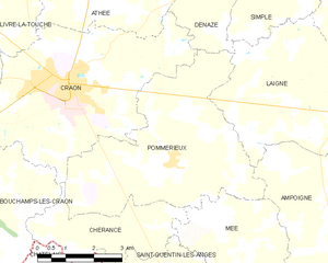
Pommerieux
- commune in Mayenne, France
- Country:
- Postal Code: 53400
- Coordinates: 47° 49' 24" N, 0° 53' 54" E
- GPS tracks (wikiloc): [Link]
- Area: 23.2 sq km
- Population: 671
- Web site: [Link]


Craon
- commune in Mayenne, France
- Country:
- Postal Code: 53400
- Coordinates: 47° 50' 53" N, 0° 56' 59" E
- GPS tracks (wikiloc): [Link]
- Area: 24.56 sq km
- Population: 4509
- Web site: [Link]


Laigné
- commune in Mayenne, France
- Country:
- Postal Code: 53200
- Coordinates: 47° 50' 31" N, 0° 49' 7" E
- GPS tracks (wikiloc): [Link]
- Area: 21.54 sq km
- Population: 867
- Web site: [Link]


Simplé
- commune in Mayenne, France
- Country:
- Postal Code: 53360
- Coordinates: 47° 53' 15" N, 0° 51' 5" E
- GPS tracks (wikiloc): [Link]
- Area: 9.1 sq km
- Population: 433