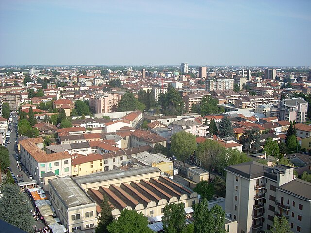
Desio (Desio)
.svg)
- Italian comune
 Hiking in Desio
Desio is a town located in the Lombardy region of Italy, in the province of Monza and Brianza, not far from Milan. While Desio itself is mainly an urban area, it serves as a good starting point for exploring nearby natural attractions and hiking trails in the surrounding areas.
Here are some hiking options and tips for exploring near Desio:
-
Parco della Brianza: The Brianza region, surrounding Desio, is known for its beautiful parks and trails. You can find trails through the hills and valleys that offer scenic views of the countryside, lakes, and historical sites.
-
Montevecchia and Curone Valley Park: Located a short distance from Desio, this park offers numerous hiking trails. You can enjoy varied terrain, including hills and forests. The views from Montevecchia itself are stunning, making it a popular destination for hikers.
-
Parco Nord Milano: This large park, located closer to Milan, offers a variety of trails for walking, hiking, and even cycling. It's a great option for those looking to hike in a more urbanized environment while still enjoying nature.
-
Lago di Pusiano: A bit further afield, this lake has scenic trails around its perimeter. The area offers a peaceful environment for hiking, with opportunities for birdwatching and enjoying the local flora and fauna.
-
Preparation and Tips:
- Check the Weather: Always check the forecast before heading out, as weather can change rapidly in this region.
- Wear Appropriate Gear: Good hiking shoes and clothing appropriate for the weather are essential. Consider bringing layers since temperatures can vary.
- Stay Hydrated and Energized: Carry enough water and snacks, especially if you plan on doing longer hikes.
- Respect Nature: Follow Leave No Trace principles to help preserve the beauty of the area for future visitors.
If you're looking for more specific trails or routes, it may be worth consulting local hiking guides or apps that focus on European trails and offer detailed maps and descriptions. Happy hiking!
- Country:

- Postal Code: 20832
- Local Dialing Code: 0362
- Licence Plate Code: MB
- Coordinates: 45° 37' 0" N, 9° 13' 0" E


- GPS tracks (wikiloc): [Link]
- AboveSeaLevel: 196 м m
- Area: 14.76 sq km
- Population: 42031
- Web site: http://www.comune.desio.mb.it
- Wikipedia en: wiki(en)
- Wikipedia: wiki(it)
- Wikidata storage: Wikidata: Q40416
- Wikipedia Commons Gallery: [Link]
- Wikipedia Commons Category: [Link]
- Freebase ID: [/m/0drrcq]
- GeoNames ID: Alt: [6540335]
- VIAF ID: Alt: [236556070]
- OSM relation ID: [45466]
- GND ID: Alt: [4542471-8]
- MusicBrainz area ID: [13774438-7e00-4dff-bfb8-420c762fc3a4]
- Quora topic ID: [Desio]
- UN/LOCODE: [ITDES]
- Encyclopædia Britannica Online ID: [place/Desio]
- ISTAT ID: 108023
- Italian cadastre code: D286
Shares border with regions:


Cesano Maderno
- Italian comune
Hiking in Cesano Maderno
Cesano Maderno, located in the Lombardy region of Italy, offers a range of hiking opportunities that showcase both its natural beauty and cultural heritage. The area is characterized by rolling hills, lush forests, and scenic views, making it an attractive destination for outdoor enthusiasts....
- Country:
- Postal Code: 20811
- Local Dialing Code: 0362
- Licence Plate Code: MB
- Coordinates: 45° 37' 38" N, 9° 8' 50" E
- GPS tracks (wikiloc): [Link]
- AboveSeaLevel: 198 м m
- Area: 11.51 sq km
- Population: 38614
- Web site: [Link]


Nova Milanese
- Italian comune
Hiking in Nova Milanese
Nova Milanese, located in the Lombardy region of Italy, is not widely known as a primary hiking destination compared to other areas in the Alps or the Italian Lakes. However, it has a charming landscape that can be explored through nearby trails and natural parks....
- Country:
- Postal Code: 20834
- Local Dialing Code: 0362
- Licence Plate Code: MB
- Coordinates: 45° 35' 0" N, 9° 12' 0" E
- GPS tracks (wikiloc): [Link]
- AboveSeaLevel: 175 м m
- Area: 5.85 sq km
- Population: 23275
- Web site: [Link]


Lissone
- Italian comune
Hiking in Lissone
Lissone, located in the Lombardy region of Italy, is primarily an urban area, but it serves as a gateway to several hiking opportunities in the surrounding Brianza hills and farther afield in the Italian Alps....
- Country:
- Postal Code: 20851
- Local Dialing Code: 039
- Licence Plate Code: MB
- Coordinates: 45° 37' 0" N, 9° 15' 0" E
- GPS tracks (wikiloc): [Link]
- AboveSeaLevel: 191 м m
- Area: 9.3 sq km
- Population: 45233
- Web site: [Link]


Bovisio-Masciago
- Italian comune
Hiking in Bovisio-Masciago
Bovisio-Masciago is a charming town located in the Lombardy region of Italy, not far from Milan. While it's not primarily known for traditional hiking trails, it is situated near several natural areas and parks that offer great opportunities for outdoor activities, including walking and hiking....
- Country:
- Postal Code: 20813
- Local Dialing Code: 0362
- Licence Plate Code: MB
- Coordinates: 45° 37' 0" N, 9° 9' 0" E
- GPS tracks (wikiloc): [Link]
- AboveSeaLevel: 188 м m
- Area: 4 sq km
- Population: 17047
- Web site: [Link]

Seregno
- Italian comune
Hiking in Seregno
Seregno, located in the Lombardy region of Italy, offers beautiful landscapes and opportunities for hiking, especially in the surrounding areas. While Seregno itself is more urban, the nearby Brianza region is known for its scenic hills, forests, and walking trails. Here are some highlights for hiking in and around Seregno:...
- Country:
- Postal Code: 20831
- Local Dialing Code: 0362
- Licence Plate Code: MB
- Coordinates: 45° 39' 0" N, 9° 12' 0" E
- GPS tracks (wikiloc): [Link]
- AboveSeaLevel: 222 м m
- Area: 13.05 sq km
- Population: 44962
- Web site: [Link]


Varedo
- Italian comune
Hiking in Varedo
Varedo is a small town located in the Lombardy region of Italy, not far from Milan. While it may not be renowned specifically for hiking, it serves as a good starting point for exploring the surrounding areas, which offer various outdoor activities....
- Country:
- Postal Code: 20814
- Local Dialing Code: 0362
- Licence Plate Code: MB
- Coordinates: 45° 36' 0" N, 9° 10' 0" E
- GPS tracks (wikiloc): [Link]
- AboveSeaLevel: 180 м m
- Area: 4.85 sq km
- Population: 13335
- Web site: [Link]


Muggiò
- Italian comune
Hiking in Muggiò
Muggiò is a town located in the Lombardy region of Italy, near Milan. While it is primarily an urban area, there are several options for hiking and enjoying nature in the surrounding regions. Here’s what you can expect:...
- Country:
- Postal Code: 20835
- Local Dialing Code: 039
- Licence Plate Code: MB
- Coordinates: 45° 36' 0" N, 9° 14' 0" E
- GPS tracks (wikiloc): [Link]
- AboveSeaLevel: 186 м m
- Area: 5.48 sq km
- Population: 23490
- Web site: [Link]