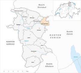
Dietikon District (Bezirk Dietikon)

- district of the canton of Zürich, Switzerland
 Hiking in Dietikon District
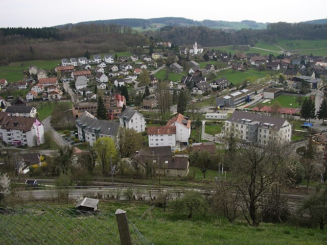
Hiking in the Dietikon District, located in the Canton of Zurich, Switzerland, offers a delightful blend of urban proximity and natural beauty. This area is characterized by its picturesque landscapes, rolling hills, and well-marked hiking trails that cater to various skill levels.
Key Highlights:
-
Trail Variety: The Dietikon District features a network of hiking trails, ranging from easy walks suitable for families to more challenging routes for experienced hikers. Trails often include scenic views of the Alps and the Limmat River.
-
Nature Reserves: The region is home to several nature reserves where you can enjoy the local flora and fauna. These areas often feature well-maintained paths and educational signage about the local ecosystem.
-
Urban Integration: Being near Zurich, you can easily access hiking trails from the city. Some trails start right from Dietikon, allowing quick escapes into nature without extensive travel.
-
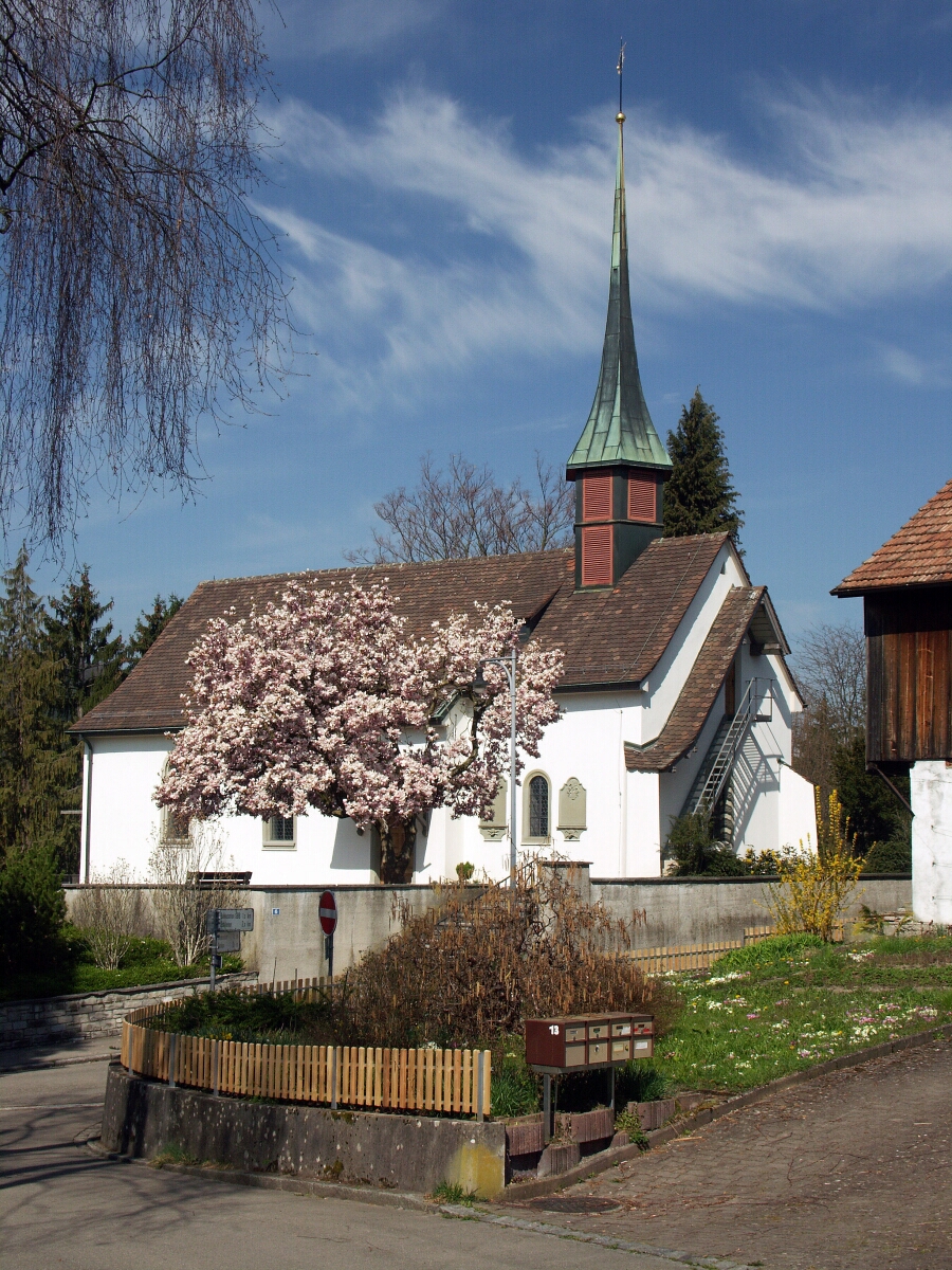
Cultural Attractions: While hiking, you can visit small villages, historical buildings, and cultural landmarks. These add an enriching dimension to your hiking experience, allowing you to learn about the region's history and culture.
-
Seasonal Hiking: Each season offers a unique experience. In spring and summer, the trails are vibrant with flowers and lush greenery, while autumn brings stunning fall colors. Winter hiking is also popular, with options for snowshoeing and winter trails.
Popular Hiking Areas:
- Zürichberg: Offers a variety of trails with sweeping views of Zurich and Lake Zurich.
- Limmat Valley: Ideal for longer, scenic hikes alongside the river.
- Uetliberg: Located a bit further but accessible from Dietikon, this mountain provides panoramic views and well-marked paths.
Tips for Hiking in Dietikon District:
- Trail Maps: Utilize local trail maps or mobile apps that feature hiking routes to help you navigate.
- Weather: Always check the weather forecast beforehand, as conditions can change rapidly.
- Gear Up Properly: Wear appropriate footwear and pack essentials like water, snacks, and a first-aid kit.
- Respect Nature: Follow local guidelines for preserving the environment, including staying on marked trails and adhering to any area-specific rules.
Overall, hiking in the Dietikon District offers a wonderful way to experience the natural beauty of Switzerland while enjoying the convenience of urban access. Whether you are a casual walker or an avid hiker, there’s something here for everyone.
- Country:

- Capital: Dietikon
- Licence Plate Code: ZH
- Coordinates: 47° 23' 0" N, 8° 25' 0" E


- GPS tracks (wikiloc): [Link]
- AboveSeaLevel: 514 м m
- Area: 60.06 sq km
- Wikipedia en: wiki(en)
- Wikipedia: wiki(de)
- Wikidata storage: Wikidata: Q180792
- Wikipedia Commons Category: [Link]
- Freebase ID: [/m/041ltj]
- GeoNames ID: Alt: [6458760]
- archINFORM location ID: [42724]
Includes regions:


Dietikon
- city in the canton of Zürich, Switzerland
Hiking in Dietikon
Dietikon, located in the Canton of Zurich, Switzerland, offers a variety of hiking options that cater to different skill levels and preferences. The region is known for its picturesque landscapes, including forests, hills, and views of the Limmat River, making it an attractive destination for outdoor enthusiasts....
- Country:
- Postal Code: 8953
- Licence Plate Code: ZH
- Coordinates: 47° 24' 20" N, 8° 24' 14" E
- GPS tracks (wikiloc): [Link]
- AboveSeaLevel: 388 м m
- Area: 9.33 sq km
- Population: 26936
- Web site: [Link]

Birmensdorf
- municipality in Switzerland
Hiking in Birmensdorf
Birmensdorf is a charming village situated near Zürich, Switzerland, that offers a variety of beautiful hiking opportunities. Nestled in the rolling hills of the Zurich region, this area provides access to scenic views and lush landscapes....
- Country:
- Postal Code: 8903
- Local Dialing Code: 044
- Licence Plate Code: ZH
- Coordinates: 47° 21' 14" N, 8° 26' 5" E
- GPS tracks (wikiloc): [Link]
- AboveSeaLevel: 463 м m
- Area: 11.38 sq km
- Population: 6385
- Web site: [Link]


Unterengstringen
- municipality in Switzerland
Hiking in Unterengstringen
Unterengstringen is a charming municipality located in the Canton of Zurich, Switzerland. While it may not be as widely known as some other hiking destinations, it offers beautiful trails and scenic views that are perfect for both casual walkers and avid hikers....
- Country:
- Postal Code: 8103
- Licence Plate Code: ZH
- Coordinates: 47° 24' 46" N, 8° 26' 59" E
- GPS tracks (wikiloc): [Link]
- AboveSeaLevel: 413 м m
- Area: 3.32 sq km
- Population: 3804
- Web site: [Link]


Weiningen
- municipality in Switzerland
Hiking in Weiningen
Weiningen, located in the Canton of Zurich in Switzerland, is a picturesque town surrounded by beautiful landscapes. It's a great starting point for a variety of hiking trails that cater to different skill levels. Here are some highlights and recommendations for hiking in and around Weiningen:...
- Country:
- Postal Code: 8104
- Licence Plate Code: ZH
- Coordinates: 47° 25' 12" N, 8° 25' 49" E
- GPS tracks (wikiloc): [Link]
- AboveSeaLevel: 432 м m
- Area: 5.41 sq km
- Population: 4760
- Web site: [Link]


Oetwil an der Limmat
- municipality in Switzerland
Hiking in Oetwil an der Limmat
Oetwil an der Limmat, located near the Limmat River in Switzerland, is a picturesque area that offers a variety of hiking opportunities suitable for different skill levels. Here are some highlights:...
- Country:
- Postal Code: 8955
- Local Dialing Code: 044
- Licence Plate Code: ZH
- Coordinates: 47° 25' 51" N, 8° 23' 39" E
- GPS tracks (wikiloc): [Link]
- AboveSeaLevel: 410 м m
- Area: 2.76 sq km
- Population: 2464
- Web site: [Link]


Geroldswil
- municipality in Switzerland
Hiking in Geroldswil
Geroldswil is a charming municipality located in the canton of Zurich, Switzerland. It's surrounded by picturesque landscapes that make it a great destination for hiking enthusiasts. Here are some key points you might find useful for hiking in and around Geroldswil:...
- Country:
- Postal Code: 8954
- Local Dialing Code: 044
- Licence Plate Code: ZH
- Coordinates: 47° 25' 14" N, 8° 24' 43" E
- GPS tracks (wikiloc): [Link]
- AboveSeaLevel: 402 м m
- Area: 1.91 sq km
- Population: 4918
- Web site: [Link]


Uitikon
- municipality in Switzerland
Hiking in Uitikon
Uitikon is a picturesque municipality located just outside of Zurich, Switzerland, making it a great destination for hiking enthusiasts. The area is characterized by its beautiful landscapes, including rolling hills, forests, and views of the surrounding mountains....
- Country:
- Postal Code: 8142
- Local Dialing Code: 044
- Licence Plate Code: ZH
- Coordinates: 47° 22' 1" N, 8° 27' 33" E
- GPS tracks (wikiloc): [Link]
- AboveSeaLevel: 567 м m
- Area: 4.38 sq km
- Population: 4239
- Web site: [Link]


Aesch
- municipality in Switzerland in the Canton of Zurich, Switzerland
Hiking in Aesch
Aesch is a charming village located near Zurich, Switzerland, and serves as a great starting point for various hiking trails. The surrounding countryside offers a mix of scenic landscapes, including hills, forests, and picturesque meadows....
- Country:
- Licence Plate Code: ZH
- Coordinates: 47° 20' 13" N, 8° 26' 17" E
- GPS tracks (wikiloc): [Link]
- AboveSeaLevel: 540 м m
- Area: 5.24 sq km
- Population: 1341
- Web site: [Link]

Urdorf
- municipality in Switzerland
Hiking in Urdorf
Urdorf is a municipality in the canton of Zurich, Switzerland, offering wonderful opportunities for hiking enthusiasts. While Urdorf itself is a bit more urban, it's surrounded by beautiful landscapes ideal for outdoor activities....
- Country:
- Postal Code: 8902
- Local Dialing Code: 044; 043
- Licence Plate Code: ZH
- Coordinates: 47° 23' 12" N, 8° 25' 40" E
- GPS tracks (wikiloc): [Link]
- AboveSeaLevel: 430 м m
- Area: 7.62 sq km
- Population: 9768
- Web site: [Link]


Schlieren
- municipality in Switzerland
Hiking in Schlieren
Schlieren, a small town located just outside of Zurich, Switzerland, offers a range of outdoor activities, including hiking. While Schlieren itself might not have extensive hiking trails within its immediate vicinity, it serves as an excellent starting point for exploring the surrounding areas....
- Country:
- Postal Code: 8952
- Licence Plate Code: ZH
- Coordinates: 47° 23' 42" N, 8° 26' 56" E
- GPS tracks (wikiloc): [Link]
- AboveSeaLevel: 410 м m
- Area: 6.38 sq km
- Population: 18666
- Web site: [Link]

Oberengstringen
- municipality in Switzerland
Hiking in Oberengstringen
Oberengstringen is a charming municipality located in the Zurich district of Switzerland, offering a variety of hiking opportunities amidst beautiful landscapes. Here are some key points to consider when hiking in the region:...
- Country:
- Postal Code: 8102
- Licence Plate Code: ZH
- Coordinates: 47° 24' 37" N, 8° 27' 58" E
- GPS tracks (wikiloc): [Link]
- AboveSeaLevel: 432 м m
- Area: 2.13 sq km
- Population: 6569
- Web site: [Link]
Shares border with regions:


Affoltern District
- district of the canton of Zürich, Switzerland
Hiking in Affoltern District
Affoltern District, located in the canton of Zurich, Switzerland, offers a variety of hiking opportunities that showcase the beautiful Swiss landscape, charming villages, and rich cultural heritage. Here are some key points about hiking in this region:...
- Country:
- Capital: Affoltern am Albis
- Licence Plate Code: ZH
- Coordinates: 47° 16' 0" N, 8° 28' 0" E
- GPS tracks (wikiloc): [Link]
- AboveSeaLevel: 664 м m
- Area: 113.01 sq km
- Web site: [Link]


Dielsdorf district
- district of the canton of Zürich, Switzerland
Hiking in Dielsdorf district
Dielsdorf District, located in the Zurich Canton of Switzerland, is a wonderful area for hiking enthusiasts. This district is characterized by a mix of beautiful landscapes, including rolling hills, lush forests, and charming villages, making it an appealing destination for both casual walkers and serious hikers....
- Country:
- Capital: Dielsdorf
- Licence Plate Code: ZH
- Coordinates: 47° 29' 0" N, 8° 27' 0" E
- GPS tracks (wikiloc): [Link]
- AboveSeaLevel: 482 м m
- Area: 152.73 sq km


Zürich District
Hiking in Zürich District
Hiking in the Zürich District offers a wonderful blend of urban and natural experiences. The area provides a variety of trails that cater to different skill levels, from easy walks suitable for families to more challenging hikes for seasoned adventurers. Here are some popular hiking spots and trails you might consider:...
- Country:
- Capital: Zürich
- Licence Plate Code: ZH
- Coordinates: 47° 23' 0" N, 8° 32' 0" E
- GPS tracks (wikiloc): [Link]
- AboveSeaLevel: 412 м m
- Area: 87.78 sq km
- Web site: [Link]