Urdorf (Urdorf)

- municipality in Switzerland
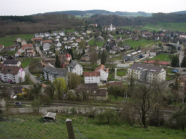
 Hiking in Urdorf
Urdorf is a municipality in the canton of Zurich, Switzerland, offering wonderful opportunities for hiking enthusiasts. While Urdorf itself is a bit more urban, it's surrounded by beautiful landscapes ideal for outdoor activities.
Hiking Trails
-
Urdorf to the Zurich Reformed Church: This is a relatively easy hike that takes you into the countryside, allowing you to experience the serene Swiss landscape. You'll get a chance to enjoy views of rolling hills and farmland.
-
Urdorf to the Uetliberg Mountain: A popular route for hikers, this trail leads to one of the most famous viewpoints in Zurich. Uetliberg offers panoramic views of the city, Lake Zurich, and the Alps on clear days.
-
Around Urdorf: There are several smaller trails and walking paths in and around Urdorf that feature scenic views and are suitable for families and casual walkers.
-
Nearby Zurich: Urdorf is conveniently located near Zurich, which means you can easily access a vast network of hiking trails in the nearby Zurich Mountains. The Sihltal and Wildnispark Zurich offer more rugged hiking options.
Best Time to Hike
- Spring and Summer (April to September): These months offer great weather and breathtaking flora. Trails are usually well-marked and accessible.
- Autumn (October): Hiking during this season provides stunning fall colors, but be mindful of changing weather conditions.
- Winter (December to March): While hiking is still possible, be prepared for snow and ice conditions, and consider snowshoes for more adventurous trails.
Tips for Hiking in Urdorf
- Trail Maps: It’s always a good idea to have a trail map or a GPS application handy to navigate the different paths.
- Weather Preparation: Switzerland’s weather can change quickly, so dress in layers and be prepared for sudden rain or temperature drops.
- Footwear: Good hiking shoes are essential to handle various trail conditions.
- Hydration and Snacks: Always carry enough water and snacks, especially on longer hikes.
Urdorf and its surroundings provide a great starting point for exploring the beautiful Swiss outdoors while also being close to urban amenities. Enjoy your hike!
- Country:

- Postal Code: 8902
- Local Dialing Code: 044; 043
- Licence Plate Code: ZH
- Coordinates: 47° 23' 12" N, 8° 25' 40" E


- GPS tracks (wikiloc): [Link]
- AboveSeaLevel: 430 м m
- Area: 7.62 sq km
- Population: 9768
- Web site: http://www.urdorf.ch
- Wikipedia en: wiki(en)
- Wikipedia: wiki(de)
- Wikidata storage: Wikidata: Q69109
- Wikipedia Commons Category: [Link]
- Freebase ID: [/m/0gt093]
- GeoNames ID: Alt: [7287390]
- VIAF ID: Alt: [246958030]
- OSM relation ID: [1682224]
- archINFORM location ID: [11127]
- HDS ID: [168]
- EMLO location ID: [2e3f413a-1eb0-4345-b5d4-a62d9e81de8a]
- Swiss municipality code: [0250]
Shares border with regions:

Rudolfstetten-Friedlisberg
- municipality in Switzerland
Hiking in Rudolfstetten-Friedlisberg
Rudolfstetten-Friedlisberg is a picturesque municipality located in the Canton of Aargau in Switzerland. This area offers a variety of hiking opportunities, showcasing beautiful landscapes, lush forests, and stunning views of the surrounding hills and valleys....
- Country:
- Postal Code: 8964
- Local Dialing Code: 056
- Licence Plate Code: AG
- Coordinates: 47° 22' 9" N, 8° 22' 55" E
- GPS tracks (wikiloc): [Link]
- AboveSeaLevel: 479 м m
- Area: 4.90 sq km
- Population: 4466
- Web site: [Link]

Birmensdorf
- municipality in Switzerland
Hiking in Birmensdorf
Birmensdorf is a charming village situated near Zürich, Switzerland, that offers a variety of beautiful hiking opportunities. Nestled in the rolling hills of the Zurich region, this area provides access to scenic views and lush landscapes....
- Country:
- Postal Code: 8903
- Local Dialing Code: 044
- Licence Plate Code: ZH
- Coordinates: 47° 21' 14" N, 8° 26' 5" E
- GPS tracks (wikiloc): [Link]
- AboveSeaLevel: 463 м m
- Area: 11.38 sq km
- Population: 6385
- Web site: [Link]


Uitikon
- municipality in Switzerland
Hiking in Uitikon
Uitikon is a picturesque municipality located just outside of Zurich, Switzerland, making it a great destination for hiking enthusiasts. The area is characterized by its beautiful landscapes, including rolling hills, forests, and views of the surrounding mountains....
- Country:
- Postal Code: 8142
- Local Dialing Code: 044
- Licence Plate Code: ZH
- Coordinates: 47° 22' 1" N, 8° 27' 33" E
- GPS tracks (wikiloc): [Link]
- AboveSeaLevel: 567 м m
- Area: 4.38 sq km
- Population: 4239
- Web site: [Link]


Bergdietikon
- municipality in Switzerland
Hiking in Bergdietikon
Bergdietikon is a charming municipality located in the canton of Aargau, Switzerland. It's situated in a picturesque region characterized by rolling hills, forests, and beautiful landscapes, making it an excellent destination for hiking enthusiasts of all levels....
- Country:
- Postal Code: 8962
- Local Dialing Code: 044
- Licence Plate Code: AG
- Coordinates: 47° 23' 39" N, 8° 23' 10" E
- GPS tracks (wikiloc): [Link]
- AboveSeaLevel: 508 м m
- Area: 5.94 sq km
- Population: 2827
- Web site: [Link]


Schlieren
- municipality in Switzerland
Hiking in Schlieren
Schlieren, a small town located just outside of Zurich, Switzerland, offers a range of outdoor activities, including hiking. While Schlieren itself might not have extensive hiking trails within its immediate vicinity, it serves as an excellent starting point for exploring the surrounding areas....
- Country:
- Postal Code: 8952
- Licence Plate Code: ZH
- Coordinates: 47° 23' 42" N, 8° 26' 56" E
- GPS tracks (wikiloc): [Link]
- AboveSeaLevel: 410 м m
- Area: 6.38 sq km
- Population: 18666
- Web site: [Link]

Zürich
- capital of the canton of Zürich, Switzerland
Hiking in Zürich
Hiking in Zürich offers a wonderful mix of urban convenience and stunning natural landscapes. The city is situated near the edge of the Swiss Alps, providing easy access to numerous trails that cater to all levels of hikers, from beginners to experienced trekkers....
- Country:
- Postal Code: 8064; 8063; 8057; 8055; 8053; 8052; 8051; 8050; 8049; 8046; 8045; 8044; 8041; 8038; 8037; 8032; 8008; 8006; 8005; 8004; 8003; 8002; 8001; 8000
- Local Dialing Code: 044; 043
- Licence Plate Code: ZH
- Coordinates: 47° 22' 43" N, 8° 32' 24" E
- GPS tracks (wikiloc): [Link]
- AboveSeaLevel: 408 м m
- Area: 87.88 sq km
- Population: 409241
- Web site: [Link]