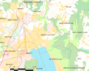
Dingy-Saint-Clair (Dingy-Saint-Clair)

- commune in Haute-Savoie, France
 Hiking in Dingy-Saint-Clair
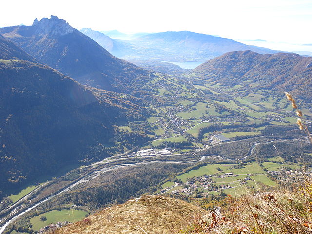
Dingy-Saint-Clair is a charming commune in the Haute-Savoie region of the French Alps, known for its beautiful landscapes and outdoor activities, including hiking. Here are some key points to consider if you're planning to hike in this area:
Trails and Difficulty
-
Variety of Trails: There are several well-marked trails in and around Dingy-Saint-Clair catering to different skill levels. Beginners might enjoy easier, shorter hikes, while experienced hikers can take on more challenging routes.
-
Scenic Views: Many of the trails offer stunning views of the surrounding mountains, valleys, and forests. The area is characterized by picturesque alpine scenery, making it a great destination for nature lovers.
-
Elevation Changes: Depending on the trail, you may encounter significant elevation changes. Make sure to choose a hike that matches your fitness level and experience.
Seasonality
-
Best Time to Hike: Late spring through early autumn (approximately May to October) is the best time for hiking in Dingy-Saint-Clair, as the weather is generally mild and the trails are clear of snow.
-
Winter Hiking: If you’re considering winter hiking, ensure you have the proper equipment and check local conditions, as snow can make trails more challenging and may require specialized gear like snowshoes or crampons.
Safety and Preparation
-
Weather Awareness: Mountain weather can be unpredictable. Always check the forecast before heading out and prepare for sudden changes in weather conditions.
-
Proper Gear: Wear sturdy hiking boots, dress in layers, and carry essential gear like a map, compass, water, and snacks. Always inform someone about your hiking plans.
-
Local Guidelines: Pay attention to local regulations and guidelines regarding wildlife, nature conservation, and trail etiquette to preserve the natural environment.
Nearby Attractions
- Lac de Annecy: Just a short drive away, this stunning lake offers additional recreational opportunities, including swimming, kayaking, and cycling.
- Local Culture: Don't miss the chance to explore nearby villages and experience local cuisine, especially fondue and other alpine specialties.
Conclusion
Hiking in Dingy-Saint-Clair can be a rewarding experience filled with beautiful landscapes and fresh air. With proper preparation and respect for the environment, you can enjoy the natural beauty of the region while challenging yourself on the trails. Always remember to follow local regulations and stay safe.
- Country:

- Postal Code: 74230
- Coordinates: 45° 54' 42" N, 6° 13' 20" E


- GPS tracks (wikiloc): [Link]
- Area: 34.12 sq km
- Population: 1395
- Wikipedia en: wiki(en)
- Wikipedia: wiki(fr)
- Wikidata storage: Wikidata: Q729459
- Wikipedia Commons Category: [Link]
- Freebase ID: [/m/03nty6h]
- GeoNames ID: Alt: [6442938]
- SIREN number: [217401025]
- BnF ID: [152743609]
- INSEE municipality code: 74102
Shares border with regions:


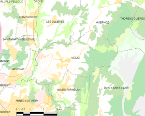
Nâves-Parmelan
- commune in Haute-Savoie, France
Hiking in Nâves-Parmelan
Nâves-Parmelan is a picturesque commune located in the Haute-Savoie region of France, nestled in the foothills of the French Alps. The area offers a range of hiking trails suited for various skill levels, making it a great destination for outdoor enthusiasts....
- Country:
- Postal Code: 74370
- Coordinates: 45° 56' 2" N, 6° 11' 24" E
- GPS tracks (wikiloc): [Link]
- Area: 5.39 sq km
- Population: 965
- Web site: [Link]

Annecy-le-Vieux
- former commune in Haute-Savoie, France
Hiking in Annecy-le-Vieux
Annecy-le-Vieux, located near the picturesque town of Annecy in the French Alps, offers a beautiful setting for hiking enthusiasts. This area is known for its stunning landscapes, crystal-clear Lake Annecy, and the surrounding mountains....
- Country:
- Postal Code: 74940
- Coordinates: 45° 55' 9" N, 6° 8' 31" E
- GPS tracks (wikiloc): [Link]
- Area: 17.01 sq km
- Population: 19990
- Web site: [Link]

Alex
- commune in Haute-Savoie, France
Hiking in Alex
Alex is a charming village located in the Haute-Savoie region of the Auvergne-Rhône-Alpes in southeastern France. Nestled in the beautiful French Alps, it serves as a great starting point for various hiking adventures, offering stunning views and diverse landscapes. Here are some highlights about hiking in and around Alex:...
- Country:
- Postal Code: 74290
- Coordinates: 45° 53' 20" N, 6° 14' 18" E
- GPS tracks (wikiloc): [Link]
- Area: 17.02 sq km
- Population: 1031
Villaz
- commune in Haute-Savoie, France
Hiking in Villaz
Villaz is a village located in the Haute-Savoie region of France, near the scenic French Alps. It's an excellent base for hikers looking to explore the surrounding mountainous terrain, enjoy breathtaking views, and experience the beauty of nature....
- Country:
- Postal Code: 74370
- Coordinates: 45° 57' 4" N, 6° 11' 23" E
- GPS tracks (wikiloc): [Link]
- Area: 15.27 sq km
- Population: 3399
- Web site: [Link]
Aviernoz
- former commune in Haute-Savoie, France
Hiking in Aviernoz
Aviernoz is a charming village located in the Haute-Savoie region of the French Alps. It's a great spot for hiking enthusiasts due to its stunning natural landscapes, including mountains, forests, and serene views of the surrounding area. Here are some key points about hiking in Aviernoz:...
- Country:
- Postal Code: 74570
- Coordinates: 45° 58' 41" N, 6° 13' 23" E
- GPS tracks (wikiloc): [Link]
- Area: 15.9 sq km
- Population: 902


La Balme-de-Thuy
- commune in Haute-Savoie, France
Hiking in La Balme-de-Thuy
La Balme-de-Thuy is a picturesque village located in the Haute-Savoie region of the French Alps, known for its beautiful landscapes and outdoor activities, particularly hiking. Here are some key points about hiking in La Balme-de-Thuy:...
- Country:
- Postal Code: 74230
- Coordinates: 45° 54' 2" N, 6° 16' 34" E
- GPS tracks (wikiloc): [Link]
- Area: 17.79 sq km
- Population: 444


Thorens-Glières
- former commune in Haute-Savoie, France
Hiking in Thorens-Glières
Thorens-Glières, located in the Haute-Savoie region of the French Alps, is a beautiful area for hiking, offering a range of trails that cater to different skill levels and experiences. The region is not only renowned for its stunning mountain landscapes but also for its historical significance, particularly related to the French Resistance during World War II....
- Country:
- Postal Code: 74570
- Coordinates: 45° 59' 49" N, 6° 14' 49" E
- GPS tracks (wikiloc): [Link]
- Area: 63.05 sq km
- Population: 3153