Domecy-sur-Cure (Domecy-sur-Cure)

- commune in Yonne, France
- Country:

- Postal Code: 89450
- Coordinates: 47° 24' 53" N, 3° 48' 36" E


- GPS tracks (wikiloc): [Link]
- Area: 20.57 sq km
- Population: 399
- Wikipedia en: wiki(en)
- Wikipedia: wiki(fr)
- Wikidata storage: Wikidata: Q220595
- Wikipedia Commons Category: [Link]
- Freebase ID: [/m/03npdhg]
- Freebase ID: [/m/03npdhg]
- GeoNames ID: Alt: [3021214]
- GeoNames ID: Alt: [3021214]
- SIREN number: [218901452]
- SIREN number: [218901452]
- BnF ID: [15279594c]
- BnF ID: [15279594c]
- PACTOLS thesaurus ID: [pcrt2tZI0mfq9M]
- PACTOLS thesaurus ID: [pcrt2tZI0mfq9M]
- INSEE municipality code: 89145
- INSEE municipality code: 89145
Shares border with regions:


Fontenay-près-Vézelay
- commune in Yonne, France
- Country:
- Postal Code: 89450
- Coordinates: 47° 24' 52" N, 3° 45' 20" E
- GPS tracks (wikiloc): [Link]
- Area: 15.48 sq km
- Population: 132
Menades
- commune in Yonne, France
- Country:
- Postal Code: 89450
- Coordinates: 47° 26' 42" N, 3° 49' 28" E
- GPS tracks (wikiloc): [Link]
- Area: 5.7 sq km
- Population: 62

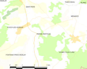
Pierre-Perthuis
- commune in Yonne, France
- Country:
- Postal Code: 89450
- Coordinates: 47° 26' 9" N, 3° 47' 49" E
- GPS tracks (wikiloc): [Link]
- Area: 7.34 sq km
- Population: 130


Saint-Aubin-des-Chaumes
- commune in Nièvre, France
- Country:
- Postal Code: 58190
- Coordinates: 47° 23' 35" N, 3° 45' 10" E
- GPS tracks (wikiloc): [Link]
- Area: 10.58 sq km
- Population: 76


Saint-André-en-Morvan
- commune in Nièvre, France
- Country:
- Postal Code: 58140
- Coordinates: 47° 23' 37" N, 3° 51' 27" E
- GPS tracks (wikiloc): [Link]
- Area: 22.82 sq km
- Population: 302


Bazoches
- commune in Nièvre, France
- Country:
- Postal Code: 58190
- Coordinates: 47° 22' 37" N, 3° 47' 12" E
- GPS tracks (wikiloc): [Link]
- Area: 14.65 sq km
- Population: 174