Dompcevrin (Dompcevrin)

- commune in Meuse, France
- Country:

- Postal Code: 55300
- Coordinates: 48° 55' 55" N, 5° 29' 23" E


- GPS tracks (wikiloc): [Link]
- Area: 10.93 sq km
- Population: 318
- Wikipedia en: wiki(en)
- Wikipedia: wiki(fr)
- Wikidata storage: Wikidata: Q576543
- Wikipedia Commons Category: [Link]
- Freebase ID: [/m/03qdqll]
- GeoNames ID: Alt: [6436986]
- SIREN number: [215501594]
- BnF ID: [152648269]
- INSEE municipality code: 55159
Shares border with regions:


Les Paroches
- commune in Meuse, France
- Country:
- Postal Code: 55300
- Coordinates: 48° 54' 30" N, 5° 30' 50" E
- GPS tracks (wikiloc): [Link]
- Area: 10.24 sq km
- Population: 419

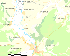
Maizey
- commune in Meuse, France
- Country:
- Postal Code: 55300
- Coordinates: 48° 55' 29" N, 5° 30' 42" E
- GPS tracks (wikiloc): [Link]
- Area: 14.91 sq km
- Population: 167
Fresnes-au-Mont
- commune in Meuse, France
- Country:
- Postal Code: 55260
- Coordinates: 48° 53' 49" N, 5° 26' 29" E
- GPS tracks (wikiloc): [Link]
- Area: 15.89 sq km
- Population: 168

Bannoncourt
- commune in Meuse, France
- Country:
- Postal Code: 55300
- Coordinates: 48° 57' 33" N, 5° 29' 57" E
- GPS tracks (wikiloc): [Link]
- AboveSeaLevel: 220 м m
- Area: 8.72 sq km
- Population: 157


Lahaymeix
- commune in Meuse, France
- Country:
- Postal Code: 55260
- Coordinates: 48° 56' 21" N, 5° 24' 36" E
- GPS tracks (wikiloc): [Link]
- Area: 12.7 sq km
- Population: 79