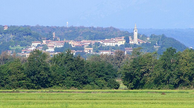
Dorzano (Dorzano)
- Italian comune
Dorzano is a charming area in the Piedmont region of Italy, known for its natural beauty and scenic landscapes. While it may not be as widely recognized as some other hiking destinations, it offers a wonderful experience for outdoor enthusiasts who enjoy picturesque trails and serene surroundings.
Here are some key points to consider when hiking in and around Dorzano:
Trails and Routes
-
Varied Terrain: The region offers a mix of easy to moderate hiking trails suitable for a range of skill levels. You can find paths that wind through forests, gentle hills, and open fields.
-
Local Routes: Check for local hiking associations or guides who can offer detailed maps and information on specific trails in Dorzano. Some common trails might pass by vineyards, farmland, and along the banks of rivers.
-
Nature Observation: The area is also great for nature observation. Look out for local flora and fauna, and enjoy the beauty of the landscapes.
Preparation
-
Weather Conditions: Always check the weather forecast before heading out. The region can experience varying weather conditions depending on the season.
-
Proper Gear: Wear appropriate hiking shoes and clothing. It’s also advisable to carry a backpack with essentials like water, snacks, a first aid kit, and a map.
-
Time of Year: Hiking in spring and fall can be particularly enjoyable due to the mild weather and beautiful scenery. Summer can get warm, while winter may have snow in higher elevations.
Local Attractions
-
Cultural Sites: In addition to hiking, explore nearby cultural sites, such as historic towns, churches, or vineyards, enriching your hiking experience with a touch of local culture.
-
Wine Tasting: Since Dorzano is close to wine regions, consider pairing your hikes with wine tastings or vineyard tours.
Safety
-
Inform Someone: Always let someone know your hiking plans, especially if you're going out alone.
-
Stay on the Trails: Stick to marked paths to ensure your safety and to help conserve the natural environment.
If you’re looking for a peaceful hiking experience away from crowds, Dorzano could be a great destination. Enjoy your hike!
- Country:

- Postal Code: 13881
- Local Dialing Code: 0161
- Licence Plate Code: BI
- Coordinates: 45° 24' 0" N, 8° 5' 0" E


- GPS tracks (wikiloc): [Link]
- AboveSeaLevel: 296 м m
- Area: 4.74 sq km
- Population: 520
- Web site: http://www.comune.dorzano.bi.it/
- Wikipedia en: wiki(en)
- Wikipedia: wiki(it)
- Wikidata storage: Wikidata: Q18065
- Wikipedia Commons Gallery: [Link]
- Wikipedia Commons Category: [Link]
- Freebase ID: [/m/0gr217]
- GeoNames ID: Alt: [6543655]
- OSM relation ID: [44983]
- UN/LOCODE: [ITDZR]
- ISTAT ID: 096025
- Italian cadastre code: D350
Shares border with regions:

Cavaglià
- Italian comune
Cavaglià is a charming town located in the Piedmont region of Italy, known for its beautiful landscapes and outdoor activities, including hiking. The area is characterized by rolling hills, forests, and agricultural land, offering a variety of hiking trails that cater to different skill levels....
- Country:

- Postal Code: 13881
- Local Dialing Code: 0161
- Licence Plate Code: BI
- Coordinates: 45° 24' 0" N, 8° 5' 0" E


- GPS tracks (wikiloc): [Link]
- AboveSeaLevel: 271 м m
- Area: 25.63 sq km
- Population: 3653
- Web site: [Link]

Roppolo
- Italian comune
Roppolo is a charming village located in the Piedmont region of Italy, nestled near the foothills of the Alps and surrounded by beautiful landscapes. While it may not be as widely recognized as some other hiking destinations, it offers some lovely trails that can be explored, especially if you're looking for a quieter experience away from the more crowded national parks....
- Country:

- Postal Code: 13883
- Local Dialing Code: 0161
- Licence Plate Code: BI
- Coordinates: 45° 25' 17" N, 8° 4' 14" E


- GPS tracks (wikiloc): [Link]
- AboveSeaLevel: 307 м m
- Area: 8.65 sq km
- Population: 880
- Web site: [Link]

Salussola
- Italian comune
Salussola, a charming municipality in the province of Biella in northern Italy, offers a variety of hiking opportunities that can cater to different skill levels and preferences. Although it's a smaller area, the scenic landscapes and lush natural surroundings make it a delightful destination for outdoor enthusiasts. Here are some highlights for hiking in Salussola:...
- Country:

- Postal Code: 13885
- Local Dialing Code: 0161
- Licence Plate Code: BI
- Coordinates: 45° 27' 0" N, 8° 7' 0" E


- GPS tracks (wikiloc): [Link]
- AboveSeaLevel: 289 м m
- Area: 38.52 sq km
- Population: 1949
- Web site: [Link]
