Drucat (Drucat)

- commune in Somme, France
- Country:

- Postal Code: 80132
- Coordinates: 50° 8' 36" N, 1° 52' 15" E


- GPS tracks (wikiloc): [Link]
- Area: 10.84 sq km
- Population: 914
- Web site: http://www.drucat-le-plessiel.fr/index.php
- Wikipedia en: wiki(en)
- Wikipedia: wiki(fr)
- Wikidata storage: Wikidata: Q69004
- Wikipedia Commons Category: [Link]
- Freebase ID: [/m/049ncc]
- GeoNames ID: Alt: [6444399]
- SIREN number: [218002491]
- BnF ID: [15276742z]
- INSEE municipality code: 80260
Shares border with regions:

Abbeville
- commune in Somme, France
- Country:
- Postal Code: 80100; 80132
- Coordinates: 50° 6' 19" N, 1° 50' 7" E
- GPS tracks (wikiloc): [Link]
- AboveSeaLevel: 8 м m
- Area: 26.42 sq km
- Population: 23278
- Web site: [Link]


Millencourt-en-Ponthieu
- commune in Somme, France
- Country:
- Postal Code: 80135
- Coordinates: 50° 9' 6" N, 1° 54' 6" E
- GPS tracks (wikiloc): [Link]
- Area: 8.62 sq km
- Population: 363

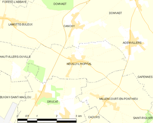
Neuilly-l'Hôpital
- commune in Somme, France
- Country:
- Postal Code: 80132
- Coordinates: 50° 10' 7" N, 1° 52' 38" E
- GPS tracks (wikiloc): [Link]
- Area: 7.69 sq km
- Population: 320


Caours
- commune in Somme, France
- Country:
- Postal Code: 80132
- Coordinates: 50° 7' 51" N, 1° 52' 56" E
- GPS tracks (wikiloc): [Link]
- Area: 6.13 sq km
- Population: 604

Buigny-Saint-Maclou
- commune in Somme, France
- Country:
- Postal Code: 80132
- Coordinates: 50° 9' 18" N, 1° 48' 48" E
- GPS tracks (wikiloc): [Link]
- Area: 7.3 sq km
- Population: 512


Hautvillers-Ouville
- commune in Somme, France
- Country:
- Postal Code: 80132
- Coordinates: 50° 10' 21" N, 1° 48' 54" E
- GPS tracks (wikiloc): [Link]
- Area: 6.06 sq km
- Population: 587
- Web site: [Link]