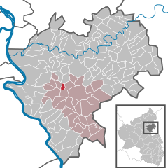
Ehr (Ehr)
- municipality of Germany
Ehr, a small municipality in the Rhineland-Palatinate region of Germany, is nestled in the picturesque landscape of the Eifel Mountains. Hiking in this area can be a delightful experience, thanks to its scenic trails, diverse flora and fauna, and tranquil surroundings. Here are a few highlights for hiking around Ehr:
Hiking Trails:
-
Eifel National Park: Nearby, this park offers numerous trails with varying difficulty levels. You can explore the rich biodiversity, including ancient beech forests and stunning viewpoints.
-
Premium Hiking Trails: The region features several premium hiking routes, such as the Eifelsteig, which stretches over 313 kilometers and showcases the diverse landscapes of the Eifel.
-
Local Trails: There are also shorter local trails that cater to family hikers or those looking for a leisurely walk. These trails often lead to charming villages and offer beautiful views of the countryside.
Things to Prepare:
- Gear: Make sure to wear comfortable hiking boots and bring weather-appropriate clothing. A good backpack with water, snacks, and a first-aid kit is essential.
- Maps: While many trails are well-marked, it’s a good idea to carry a detailed map or use a reliable hiking app for navigation.
Best Times to Hike:
The best times for hiking in the Eifel region are during spring and autumn when the weather is mild, and the landscapes are particularly beautiful. Summer can also be great, but be prepared for hotter temperatures.
Additional Activities:
In addition to hiking, you can enjoy other outdoor activities, such as cycling, bird-watching, and exploring local cultural sites, including historical towns and castles.
Local Facilities:
While Ehr is quite small, nearby towns like Monschau and Malmedy offer amenities such as restaurants, accommodations, and tourist information centers.
Remember to respect nature, follow local guidelines, and leave no trace to help preserve the beauty of the Eifel region for future hikers. Enjoy your time exploring the trails of Ehr!
- Country:

- Postal Code: 56357
- Local Dialing Code: 06776
- Licence Plate Code: EMS
- Coordinates: 50° 14' 18" N, 7° 47' 3" E


- GPS tracks (wikiloc): [Link]
- AboveSeaLevel: 260 м m
- Area: 1.22 sq km
- Population: 71
- Web site: http://www.vgnastaetten.de/
- Wikipedia en: wiki(en)
- Wikipedia: wiki(de)
- Wikidata storage: Wikidata: Q693225
- Wikipedia Commons Category: [Link]
- Freebase ID: [/m/02z3gwk]
- GeoNames ID: Alt: [6554019]
- VIAF ID: Alt: [167123203]
- OSM relation ID: [540449]
- GND ID: Alt: [10009386-3]
- Historical Gazetteer (GOV) ID: [EHREHR_W5429]
- German municipality key: 07141035

