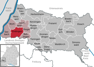
Endingen am Kaiserstuhl (Endingen am Kaiserstuhl)
- town in Baden-Württemberg, Germany
 Hiking in Endingen am Kaiserstuhl
Endingen am Kaiserstuhl is a picturesque town located in Baden-Württemberg, Germany, known for its beautiful landscapes and vineyards. The region is part of the Kaiserstuhl mountain range and offers various hiking opportunities that cater to different skill levels. Here are some highlights and tips for hiking in this area:
Trails and Routes
-
Kaiserstuhl Nature Park: The park features numerous hiking trails that explore the diverse flora and fauna of the region. Trails often provide stunning views of the surrounding vineyards, rolling hills, and the nearby Black Forest.
-
Vineyard Trails: Many trails weave through the local vineyards, allowing hikers to enjoy not only the scenery but also the local wine culture. The walking paths often include signage about the grape varieties and winemaking process.
-
Panoramaweg: This is a popular circular hiking trail that offers panoramic views from various points along the route. It's a great option for those wanting to experience the best vistas the region has to offer.
-
Waterfall Trails: Some hikes lead to small waterfalls or streams, providing a refreshing nature experience. Look for shorter trails if you're hiking with families or beginners.
Difficulty Levels
The trails in and around Endingen am Kaiserstuhl vary in difficulty:
- Easy: Many vineyard paths are flat and easy to traverse, ideal for families and leisurely walks.
- Moderate: Some trails can include gentle elevation changes, making them suitable for more active hikers.
- Challenging: There are steeper paths for those looking for a more strenuous hiking experience, often leading to higher viewpoints.
Best Times to Hike
Spring (April to June) and Autumn (September to November) are popular times for hiking in this region. The weather is usually mild, and the changing seasons offer beautiful scenery, particularly during the fall grape harvest.
Equipment and Preparation
- Footwear: Be sure to wear comfortable, sturdy hiking shoes or boots as some trails may have uneven terrain.
- Water and Snacks: Carry enough water and some snacks to keep your energy up, especially on longer hikes.
- Navigation Tools: While many trails are well-marked, it's always a good idea to have a map or a GPS app handy.
Recommendations
- Check local hiking information centers for trail maps and updates on trail conditions.
- Consider joining a guided hiking tour if you're unfamiliar with the area or looking for a social experience.
- Don’t forget to take breaks to enjoy the beautiful scenery and perhaps sample some local wines from the vineyards!
Hiking in Endingen am Kaiserstuhl offers a unique blend of nature and culture, making it a rewarding experience for outdoor enthusiasts of all levels. Enjoy your hike!
- Country:

- Postal Code: 79346
- Local Dialing Code: 07642
- Licence Plate Code: EM
- Coordinates: 48° 8' 27" N, 7° 42' 23" E


- GPS tracks (wikiloc): [Link]
- AboveSeaLevel: 186 м m
- Area: 26.71 sq km
- Population: 9225
- Web site: http://www.endingen.de/
- Wikipedia en: wiki(en)
- Wikipedia: wiki(de)
- Wikidata storage: Wikidata: Q168511
- Wikipedia Commons Category: [Link]
- Freebase ID: [/m/02xbpn]
- GeoNames ID: Alt: [2930383]
- BnF ID: [124886878]
- VIAF ID: Alt: [129037272]
- OSM relation ID: [1124262]
- GND ID: Alt: [4014640-6]
- archINFORM location ID: [12132]
- Library of Congress authority ID: Alt: [n82255703]
- Historical Gazetteer (GOV) ID: [ENDUHLJN38UD]
- German municipality key: 08316012
