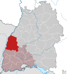
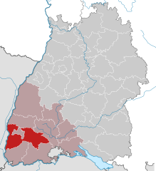
Freiburg Government Region (Regierungsbezirk Freiburg)

- administrative subdivision and region of Baden-Württemberg, Germany
 Hiking in Freiburg Government Region
Freiburg, located in the southwestern part of Germany, is a gateway to some stunning hiking opportunities, particularly due to its proximity to the Black Forest (Schwarzwald) region. Here are some key points to consider when planning a hiking trip in and around Freiburg:
Trails and Routes
-
Schauinsland: This mountain near Freiburg offers various hiking trails with rewarding panoramic views of the Rhine Valley and the Vosges Mountains. The Schauinslandbahn, a cable car, can take you up to start your hike.
-
Lorettoberg: A short, accessible hike that provides beautiful views of Freiburg and is perfect for a quick outing. The trail leads through nice woodlands and is suitable for families.
-
Hiking to the Feldberg: The Feldberg is the highest peak in the Black Forest and has numerous trails leading to it. The hike can be challenging but offers stunning views and diverse landscapes.
-
Gipfeltour zu den Sieben Tälern: A popular hiking route that takes you through several valleys and offers glimpses of quiet streams and forested areas. The route takes you off the beaten path and showcases the natural beauty of the region.
Nature and Scenery
- The Black Forest is known for its dense woods, picturesque villages, and lush valleys. As you hike, you’ll encounter diverse flora and fauna, charming streams, and traditional Black Forest homes.
Best Seasons to Hike
- Spring (April to June): Flowers are blooming, temperatures are mild, and trails are generally less crowded.
- Summer (July to September): The weather is warm, making it great for hiking, but some trails can be busier.
- Autumn (October): The fall colors make the hikes particularly beautiful, but weather can be unpredictable.
- Winter (December to February): Some areas may be suitable for winter hiking; however, snow conditions should be checked beforehand.
Tips for Hiking in Freiburg
- Planning: Always check trail maps and condition reports before heading out.
- Weather Preparedness: The weather can change quickly, especially in mountainous areas, so bring layers.
- Hydration and Snacks: Carry enough water and energy snacks, especially for longer hikes.
- Footwear: Wear sturdy hiking boots for comfort and support, particularly on rugged trails.
- Navigation Tools: Consider a reliable GPS device or a hiking app, as signposting can vary.
Local Amenities
Freiburg has a vibrant city center with plenty of eateries, shops for hiking gear, and accommodations ranging from hotels to guesthouses, making it a comfortable base for hiking enthusiasts.
Overall, Freiburg and its surrounding areas offer a wide variety of hiking experiences suitable for all levels of hikers, from relaxed walks to challenging treks. Enjoy your hiking adventures!
- Country:

- Capital: Freiburg im Breisgau
- Coordinates: 48° 0' 0" N, 8° 19' 48" E


- GPS tracks (wikiloc): [Link]
- Area: 9347 sq km
- Web site: http://www.rp.baden-wuerttemberg.de/
- Wikipedia en: wiki(en)
- Wikipedia: wiki(de)
- Wikidata storage: Wikidata: Q8167
- Wikipedia Commons Category: [Link]
- Freebase ID: [/m/01bntv]
- VIAF ID: Alt: [124369919]
- OSM relation ID: [2106112]
- GND ID: Alt: [2056243-3]
- Library of Congress authority ID: Alt: [n83033010]
- TGN ID: [7192170]
- NUTS code: [DE13]
- FAST ID: [1331907]
- US National Archives Identifier: 10037195
Includes regions:


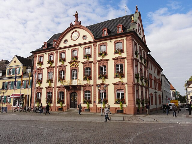
Freiburg im Breisgau
- large city in Baden-Württemberg, Germany
Hiking in Freiburg im Breisgau
Freiburg im Breisgau, located in the southwest of Germany, is a wonderful base for hiking enthusiasts. Nestled at the edge of the Black Forest, Freiburg not only boasts a charming old town but also provides access to numerous hiking trails that vary in difficulty and scenery. Here are some highlights about hiking in the area:...
- Country:
- Postal Code: 79098–79117
- Local Dialing Code: 07665; 07664; 0761
- Licence Plate Code: FR
- Coordinates: 47° 59' 41" N, 7° 50' 59" E
- GPS tracks (wikiloc): [Link]
- AboveSeaLevel: 278 м m
- Area: 153.04 sq km
- Population: 227590
- Web site: [Link]
Ortenau
- district of Baden-Württemberg, Germany
Hiking in Ortenau
Ortenaukreis, located in the Baden-Württemberg region of Germany, offers a diverse range of hiking opportunities, making it an ideal destination for both novice and experienced hikers. Here are some highlights about hiking in this picturesque area:...
- Country:
- Capital: Offenburg
- Licence Plate Code: OG
- Coordinates: 48° 25' 0" N, 8° 0' 0" E
- GPS tracks (wikiloc): [Link]
- AboveSeaLevel: 168 м m
- Area: 1850.74 sq km
- Population: 411700
- Web site: [Link]
Emmendingen
- district of Baden-Württemberg, Germany
Hiking in Emmendingen
Emmendingen, located in the southwestern part of Germany in the state of Baden-Württemberg, offers beautiful hiking opportunities with its diverse landscapes, including rolling hills, forests, vineyards, and the scenic Black Forest nearby. Here are some highlights and tips for hiking in the Emmendingen district:...
- Country:
- Capital: Emmendingen
- Licence Plate Code: EM
- Coordinates: 48° 6' 0" N, 7° 48' 0" E
- GPS tracks (wikiloc): [Link]
- AboveSeaLevel: 352 м m
- Area: 679.90 sq km
- Population: 157399
- Web site: [Link]
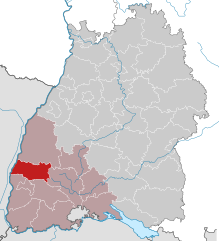
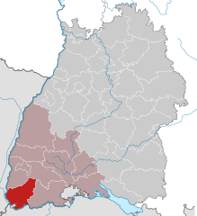
Breisgau-Hochschwarzwald
- district of Baden-Württemberg, Germany
Hiking in Breisgau-Hochschwarzwald
Breisgau-Hochschwarzwald is a spectacular region in southwestern Germany, known for its diverse landscapes, lush forests, and scenic trails. It's located in the state of Baden-Württemberg and offers a myriad of hiking opportunities suitable for all skill levels. Here are some highlights about hiking in the area:...
- Country:
- Capital: Freiburg im Breisgau
- Licence Plate Code: FR
- Coordinates: 47° 57' 0" N, 7° 51' 0" E
- GPS tracks (wikiloc): [Link]
- AboveSeaLevel: 394 м m
- Area: 1378.30 sq km
- Population: 247711
- Web site: [Link]

Lörrach
- district of Baden-Württemberg, Germany
Hiking in Lörrach
Lörrach is a district located in southern Germany, near the borders with Switzerland and France. It is surrounded by the scenic beauty of the Black Forest and offers a variety of hiking opportunities for outdoor enthusiasts. Here’s some information about hiking in the Lörrach area:...
- Country:
- Capital: Lörrach
- Licence Plate Code: LÖ
- Coordinates: 47° 39' 0" N, 7° 42' 0" E
- GPS tracks (wikiloc): [Link]
- AboveSeaLevel: 621 м m
- Area: 806.81 sq km
- Population: 220606
- Web site: [Link]


Waldshut
- district of Baden-Württemberg, Germany
Hiking in Waldshut
Waldshut is a beautiful district in the state of Baden-Württemberg, Germany, known for its stunning natural landscapes, which make it an excellent destination for hikers. The district is situated near the borders of Switzerland and provides a variety of hiking opportunities suitable for different skill levels. Here are some highlights and suggestions for hiking in Waldshut:...
- Country:
- Capital: Waldshut-Tiengen
- Licence Plate Code: WT
- Coordinates: 47° 37' 48" N, 8° 12' 0" E
- GPS tracks (wikiloc): [Link]
- AboveSeaLevel: 729 м m
- Area: 1131.19 sq km
- Population: 163699
- Web site: [Link]

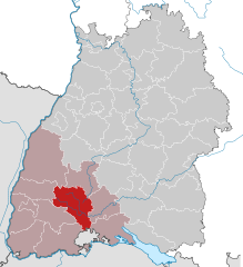
Schwarzwald-Baar
- district of Baden-Württemberg, Germany
Hiking in Schwarzwald-Baar
The Schwarzwald-Baar-Kreis in Baden-Württemberg, Germany, offers a diverse range of hiking opportunities, with its stunning landscapes characterized by dense forests, rolling hills, and picturesque villages. Here are some highlights and tips for hiking in the Schwarzwald-Baar-Kreis:...
- Country:
- Capital: Villingen-Schwenningen
- Licence Plate Code: VS
- Coordinates: 48° 1' 0" N, 8° 26' 0" E
- GPS tracks (wikiloc): [Link]
- AboveSeaLevel: 749 м m
- Area: 1025.24 sq km
- Web site: [Link]


Konstanz
- district in Baden-Württemberg, Germany
Hiking in Konstanz
Hiking in the Konstanz district, located in the southern part of Germany near the borders with Switzerland and Austria, offers a blend of stunning natural beauty and cultural experiences. The area is characterized by the presence of Lake Constance (Bodensee), rolling hills, scenic vineyards, and picturesque towns. Here are some highlights and popular hiking options in the Konstanz district:...
- Country:
- Capital: Konstanz
- Licence Plate Code: KN
- Coordinates: 47° 49' 0" N, 8° 53' 0" E
- GPS tracks (wikiloc): [Link]
- AboveSeaLevel: 437 м m
- Area: 817.95 sq km
- Population: 270568
- Web site: [Link]


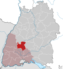
Tuttlingen
- district of Baden-Württemberg, Germany
Hiking in Tuttlingen
Tuttlingen district, located in the southwestern part of Germany, is a beautiful region known for its diverse landscapes, including hills, forests, and rivers. This area is part of the Swabian Jura (Schwäbische Alb), making it an excellent destination for hiking enthusiasts....
- Country:
- Capital: Tuttlingen
- Licence Plate Code: TUT
- Coordinates: 48° 0' 0" N, 8° 48' 0" E
- GPS tracks (wikiloc): [Link]
- AboveSeaLevel: 831 м m
- Area: 734.40 sq km
- Population: 132476
- Web site: [Link]

Rottweil
- district of Baden-Württemberg, Germany
Hiking in Rottweil
Rottweil, located in the Baden-Württemberg region of Germany, offers a range of hiking opportunities that cater to various skill levels. The district boasts beautiful landscapes, including forests, hills, and rivers, along with rich historical sites. Here are some highlights for hikers in the area:...
- Country:
- Capital: Rottweil
- Licence Plate Code: RW
- Coordinates: 48° 10' 12" N, 8° 37' 48" E
- GPS tracks (wikiloc): [Link]
- AboveSeaLevel: 667 м m
- Area: 769.48 sq km
- Population: 135553
- Web site: [Link]