Esnes-en-Argonne (Esnes-en-Argonne)

- commune in Meuse, France
- Country:

- Postal Code: 55100
- Coordinates: 49° 12' 28" N, 5° 12' 41" E


- GPS tracks (wikiloc): [Link]
- Area: 14.76 sq km
- Population: 136
- Wikipedia en: wiki(en)
- Wikipedia: wiki(fr)
- Wikidata storage: Wikidata: Q939685
- Wikipedia Commons Category: [Link]
- Freebase ID: [/m/03qdqtg]
- GeoNames ID: Alt: [6437000]
- SIREN number: [215501800]
- BnF ID: [152648478]
- VIAF ID: Alt: [234772631]
- INSEE municipality code: 55180
Shares border with regions:


Béthincourt
- commune in Meuse, France
- Country:
- Postal Code: 55270
- Coordinates: 49° 15' 9" N, 5° 13' 52" E
- GPS tracks (wikiloc): [Link]
- Area: 13.32 sq km
- Population: 35

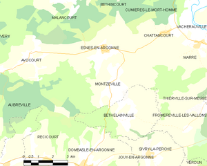
Montzéville
- commune in Meuse, France
- Country:
- Postal Code: 55100
- Coordinates: 49° 11' 29" N, 5° 13' 16" E
- GPS tracks (wikiloc): [Link]
- Area: 17.65 sq km
- Population: 156


Malancourt
- commune in Meuse, France
- Country:
- Postal Code: 55270
- Coordinates: 49° 14' 31" N, 5° 10' 47" E
- GPS tracks (wikiloc): [Link]
- Area: 16.52 sq km
- Population: 65

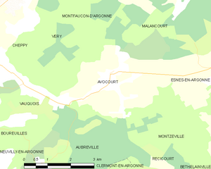
Avocourt
- commune in Meuse, France
- Country:
- Postal Code: 55270
- Coordinates: 49° 12' 25" N, 5° 8' 33" E
- GPS tracks (wikiloc): [Link]
- Area: 14.66 sq km
- Population: 112


Cumières-le-Mort-Homme
- commune in Meuse, France
- Country:
- Postal Code: 55100
- Coordinates: 49° 13' 58" N, 5° 16' 51" E
- GPS tracks (wikiloc): [Link]
- AboveSeaLevel: 188 м m
- Area: 6.11 sq km
- Population: 0


Chattancourt
- commune in Meuse, France
- Country:
- Postal Code: 55100
- Coordinates: 49° 13' 3" N, 5° 16' 4" E
- GPS tracks (wikiloc): [Link]
- Area: 10.36 sq km
- Population: 181