Füllinsdorf (Füllinsdorf)

- municipality in Switzerland
 Hiking in Füllinsdorf
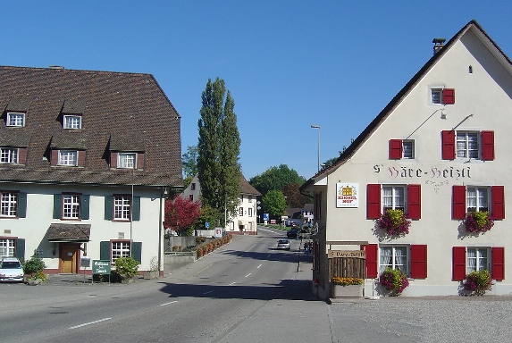
Füllinsdorf is a charming village located near Basel in the canton of Basel-Landschaft, Switzerland. While the village itself might not have extensive hiking trails, its proximity to the surrounding areas offers various hiking opportunities.
Hiking Opportunities Near Füllinsdorf:
-
Reinach and the Birs River: Just a short distance from Füllinsdorf, you can access scenic routes along the Birs River. The Birs offers beautiful landscapes and a peaceful walking experience.
-
Basel Hiking Trails: The region around Basel features a network of well-marked hiking trails. You can explore the nearby Jura Mountains, which are known for their stunning views, diverse flora and fauna, and various trail options ranging from easy to more challenging.
-
Two Rivers Trail: This trail allows you to hike along both the Rhine and Birs rivers, offering picturesque views and a chance to experience local wildlife and nature.
-
Augusterberg: A popular hiking destination nearby, Augusterberg offers various trails with fantastic views over the Rhine valley. The paths vary in difficulty, accommodating both leisurely walkers and more experienced hikers.
-
Nature Reserves: There are several nature reserves around Füllinsdorf where you can immerse yourself in nature while enjoying well-maintained paths suitable for hiking.
Tips for Hiking in the Area:
- Trail Maps: Always carry a trail map or use a reliable hiking app to keep track of your route.
- Weather Check: The weather in Switzerland can change rapidly, so check forecasts before heading out.
- Proper Gear: Wear sturdy hiking shoes and dress in layers. The terrain can vary, and it's essential to be prepared.
- Local Information: Stop by local tourist information centers for updates on trails, conditions, and suggestions on where to hike.
Exploring the areas around Füllinsdorf can lead to memorable hiking experiences amidst the natural beauty of Switzerland.
- Country:

- Postal Code: 4414
- Local Dialing Code: 061
- Licence Plate Code: BL
- Coordinates: 47° 30' 39" N, 7° 43' 55" E


- GPS tracks (wikiloc): [Link]
- AboveSeaLevel: 388 м m
- Area: 4.62 sq km
- Population: 4472
- Web site: http://www.fuellinsdorf.ch
- Wikipedia en: wiki(en)
- Wikipedia: wiki(de)
- Wikidata storage: Wikidata: Q66523
- Wikipedia Commons Category: [Link]
- Freebase ID: [/m/0fn23p]
- GeoNames ID: Alt: [7285876]
- VIAF ID: Alt: [143066926]
- OSM relation ID: [1683648]
- HDS ID: [1207]
- Swiss municipality code: [2825]
Shares border with regions:

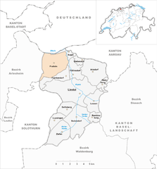
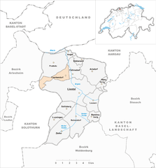
Pratteln
- municipality in Switzerland
Hiking in Pratteln
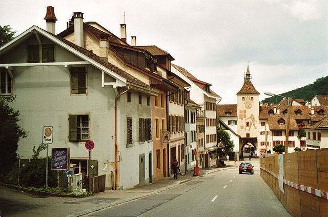
Pratteln, located in the Basel-Landschaft region of Switzerland, offers a variety of hiking opportunities that cater to different skill levels. The area is rich in natural beauty, featuring lush forests, rolling hills, and panoramic views of the surrounding landscape, including the nearby Jura Mountains....
- Country:
- Postal Code: 4133
- Local Dialing Code: 061
- Licence Plate Code: BL
- Coordinates: 47° 31' 7" N, 7° 41' 34" E
- GPS tracks (wikiloc): [Link]
- AboveSeaLevel: 292 м m
- Area: 10.70 sq km
- Population: 16388
- Web site: [Link]

Augst
- municipality in Switzerland
Hiking in Augst
Hiking in August can be a fantastic experience, depending on the location and weather conditions. Here are some general points to consider when planning a hike during this month:...
- Country:
- Postal Code: 4302
- Local Dialing Code: 061
- Licence Plate Code: BL
- Coordinates: 47° 31' 55" N, 7° 43' 2" E
- GPS tracks (wikiloc): [Link]
- AboveSeaLevel: 266 м m
- Area: 1.64 sq km
- Population: 1011
- Web site: [Link]


Arisdorf
- municipality in Switzerland
Hiking in Arisdorf
Arisdorf, located in the Canton of Basel-Landschaft in Switzerland, offers a variety of hiking opportunities in a picturesque setting. The region is characterized by beautiful countryside, rolling hills, and forested areas, making it ideal for outdoor enthusiasts....
- Country:
- Postal Code: 4422
- Local Dialing Code: 061
- Licence Plate Code: BL
- Coordinates: 47° 30' 46" N, 7° 45' 54" E
- GPS tracks (wikiloc): [Link]
- AboveSeaLevel: 363 м m
- Area: 9.99 sq km
- Population: 1633
- Web site: [Link]

Frenkendorf
- municipality in Switzerland
Hiking in Frenkendorf
Frenkendorf is a charming municipality located in the Basel-Landschaft district of Switzerland, surrounded by scenic landscapes and rolling hills. Hiking in Frenkendorf offers a variety of trails that cater to different skill levels, making it a great destination for both novice and experienced hikers....
- Country:
- Postal Code: 4402
- Local Dialing Code: 061
- Licence Plate Code: BL
- Coordinates: 47° 30' 3" N, 7° 41' 49" E
- GPS tracks (wikiloc): [Link]
- AboveSeaLevel: 412 м m
- Area: 4.58 sq km
- Population: 6471
- Web site: [Link]
Giebenach
- municipality in Switzerland
Hiking in Giebenach
Giebenach is a small village in Switzerland, located in the picturesque region of the Jura mountains. While it may not be as well-known as some other hiking destinations, it offers a variety of trails and beautiful landscapes for outdoor enthusiasts....
- Country:
- Postal Code: 4304
- Local Dialing Code: 061
- Licence Plate Code: BL
- Coordinates: 47° 31' 24" N, 7° 44' 18" E
- GPS tracks (wikiloc): [Link]
- AboveSeaLevel: 360 м m
- Area: 1.32 sq km
- Population: 1031
- Web site: [Link]

Liestal
- town in, and capital of, the Swiss canton of Basel-Country
Hiking in Liestal
Liestal, located in the Basel-Landschaft region of Switzerland, is a beautiful area that offers a variety of hiking opportunities suited for all levels of hikers. Here are some highlights about hiking in and around Liestal:...
- Country:
- Postal Code: 4410
- Local Dialing Code: 061
- Licence Plate Code: BL
- Coordinates: 47° 29' 2" N, 7° 44' 6" E
- GPS tracks (wikiloc): [Link]
- AboveSeaLevel: 342 м m
- Area: 18.19 sq km
- Population: 14269
- Web site: [Link]