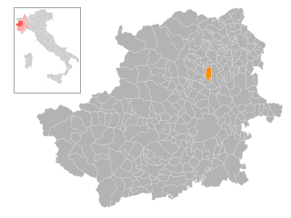
Favria (Favria)
- Italian comune
Favria is a charming municipality located in the province of Turin, Piedmont, Italy. Nestled at the foothills of the Alps, it offers a variety of hiking opportunities for nature enthusiasts and outdoor adventurers. Here are some aspects of hiking in and around Favria:
Hiking Trails
-
Scenic Routes: Favria has several marked trails suitable for various skill levels. The paths often wind through beautiful landscapes, including forests, rolling hills, and vineyards.
-
Alp Perspective: Being close to the Alps, hiking trails in the area offer stunning panoramic views. You can find trails that lead to higher elevations, giving hikers a chance to enjoy the breathtaking scenery of the peaks.
-
Rural Exploration: Many trails also pass through quaint villages and farmland, allowing hikers to experience the local culture and cuisine.
Recommended Hikes
- The Walk to the Sacra di San Michele: While a bit of a trek, this historic abbey offers not only spiritual significance but also magnificent views of the surrounding region.
- Alpe Veglia and Alpe Devero Nature Park: A short drive from Favria, this area features trails that cater to both casual walkers and more experienced hikers.
Best Time to Hike
- Spring and Fall: These seasons are particularly beautiful for hiking in Favria, with blooming flowers and colorful foliage, respectively. The weather is generally mild and pleasant.
- Summer: While perfect for exploring, be mindful of potential heat and make sure to carry enough water.
Tips for Hiking in Favria
- Preparation: Always check local weather conditions before heading out, and ensure you have appropriate gear and enough supplies.
- Safety: Inform someone about your hiking plan, and consider hiking with a partner, especially in more remote areas.
- Respect Nature: Follow the principles of Leave No Trace to preserve the natural beauty of the area for future hikers.
Local Culture
After a day of hiking, consider enjoying local cuisine in Favria. The region is known for its wine, traditional dishes, and hospitality.
Hiking in Favria can be a rewarding experience with its combination of natural beauty, historical sites, and cultural richness. Enjoy your adventure!
- Country:

- Postal Code: 10083
- Local Dialing Code: 0124
- Licence Plate Code: TO
- Coordinates: 45° 20' 0" N, 7° 41' 0" E


- GPS tracks (wikiloc): [Link]
- AboveSeaLevel: 316 м m
- Area: 14.85 sq km
- Population: 5186
- Web site: http://www.comune.favria.to.it/portal/home.php
- Wikipedia en: wiki(en)
- Wikipedia: wiki(it)
- Wikidata storage: Wikidata: Q9343
- Wikipedia Commons Category: [Link]
- Freebase ID: [/m/0g6w1d]
- GeoNames ID: Alt: [6538058]
- VIAF ID: Alt: [246998287]
- OSM relation ID: [44660]
- UN/LOCODE: [ITVRF]
- ISTAT ID: 001101
- Italian cadastre code: D520
Shares border with regions:


Rivarolo Canavese
- Italian comune
Rivarolo Canavese, located in the Piedmont region of Italy, is a charming small town that serves as an excellent base for hiking and exploring the beautiful surrounding landscape of the Canavese area. Nestled near the foothills of the Alps, the region offers a variety of trails suitable for different skill levels....
- Country:

- Postal Code: 10086
- Local Dialing Code: 0124
- Licence Plate Code: TO
- Coordinates: 45° 20' 0" N, 7° 43' 0" E


- GPS tracks (wikiloc): [Link]
- AboveSeaLevel: 304 м m
- Area: 32.25 sq km
- Population: 12539
- Web site: [Link]


Busano
- Italian comune
Busano is a charming municipality located in the province of Turin, Italy, and is known for its beautiful natural landscapes and outdoor activities, including hiking. Nestled in the foothills of the Alps, Busano offers a variety of trails that cater to different skill levels, making it an ideal destination for both novice and experienced hikers....
- Country:

- Postal Code: 10080
- Local Dialing Code: 0124
- Licence Plate Code: TO
- Coordinates: 45° 20' 0" N, 7° 39' 0" E


- GPS tracks (wikiloc): [Link]
- AboveSeaLevel: 317 м m
- Area: 5.06 sq km
- Population: 1642
- Web site: [Link]


Front
- Italian comune
Hiking in the Piedmont region of France, particularly around the Front area, offers a unique blend of natural beauty, diverse landscapes, and cultural history. The Piedmont area, known for its rolling hills, vineyards, and picturesque small towns, provides a variety of hiking opportunities suitable for different skill levels....
- Country:

- Postal Code: 10070
- Local Dialing Code: 011
- Licence Plate Code: TO
- Coordinates: 45° 17' 0" N, 7° 40' 0" E


- GPS tracks (wikiloc): [Link]
- AboveSeaLevel: 270 м m
- Area: 10.95 sq km
- Population: 1670
- Web site: [Link]


Oglianico
- Italian comune
Oglianico is a municipality located in the Piedmont region of Italy, near Turin. While it may not be as widely recognized as some of the more famous hiking destinations, it offers some beautiful trails and scenic views that can be enjoyable for hikers. Here are some aspects to consider when hiking in and around Oglianico:...
- Country:

- Postal Code: 10080
- Local Dialing Code: 0124
- Licence Plate Code: TO
- Coordinates: 45° 20' 0" N, 7° 42' 0" E


- GPS tracks (wikiloc): [Link]
- AboveSeaLevel: 326 м m
- Area: 6.3 sq km
- Population: 1506
- Web site: [Link]

