
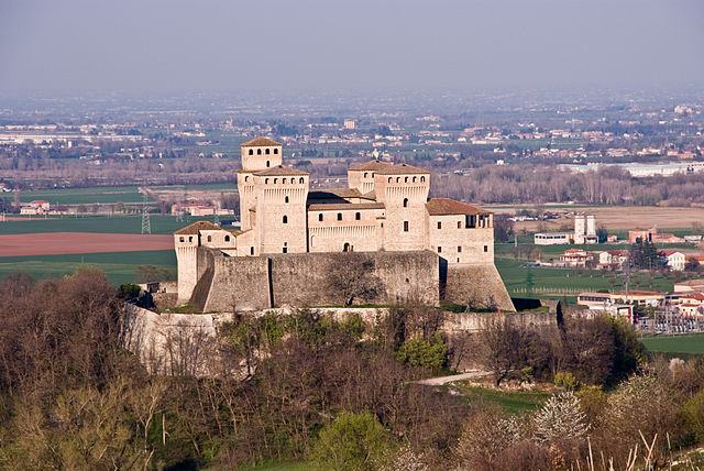
Felino (Felino)
.svg)
- Italian comune
 Hiking in Felino
Felino is a charming town located in the Emilia-Romagna region of Italy, known for its rich history and beautiful landscapes. The area surrounding Felino offers various hiking opportunities that cater to different skill levels, allowing hikers to explore natural beauty, vineyards, and historical sites.
Hiking Trails in and Around Felino
-
Colline di Parma (Parma Hills): The hills surrounding Felino are ideal for hiking. You can find several trails that weave through the vineyards, olive groves, and forests, offering breathtaking views of the countryside and the distant Apennines. The trails vary in difficulty, making them suitable for both beginners and seasoned hikers.
-
Parco del Tigri: This nearby park features a network of trails that are great for nature walks and hikes. The trails are often lined with lush foliage and provide the chance to spot local wildlife. It's a peaceful area that allows hikers to enjoy the tranquility of nature.
-
Castles and Fortresses Trail: Felino is near several historic castles, including the Castle of Felino itself. Some trails connect these historic sites, allowing you to combine hiking with cultural exploration. This trail is perfect for those interested in history as they hike.
-
Monte Barigazzo: A more strenuous option, hiking in the Monte Barigazzo area offers dramatic views and a more rugged terrain. This trail is suited for experienced hikers looking for a challenge and an opportunity to see the natural beauty of the Apennines.
Tips for Hiking in Felino
-
Best Time to Hike: The best times to hike in this region are spring (April to June) and fall (September to October) when the weather is mild, and the countryside is particularly beautiful. Summer can be hot, and winter may bring snow in higher elevations.
-
What to Bring: Depending on the trail, pack water, snacks, a map or GPS, hiking poles, and appropriate footwear. A first aid kit is also recommended.
-
Local Cuisine: After a day of hiking, enjoy some local cuisine. Felino is famous for its salami, and local trattorias often serve up delicious traditional dishes.
-
Respect Nature: Always stay on marked trails, follow local regulations, and carry out what you bring in to preserve the beauty of the environment.
Conclusion
Hiking in Felino offers a blend of natural beauty, historical exploration, and a chance to experience the local culture. Whether you're seeking a leisurely stroll through vineyards or a challenging hike in the hills, Felino has something to offer every hiker. Always check local maps and guides to ensure you have the latest information about trails and conditions.
- Country:

- Postal Code: 43035
- Local Dialing Code: 0521
- Licence Plate Code: PR
- Coordinates: 44° 41' 43" N, 10° 14' 30" E


- GPS tracks (wikiloc): [Link]
- AboveSeaLevel: 180 м m
- Area: 38.35 sq km
- Population: 8873
- Web site: http://www.comune.felino.pr.it
- Wikipedia en: wiki(en)
- Wikipedia: wiki(it)
- Wikidata storage: Wikidata: Q100808
- Wikipedia Commons Category: [Link]
- Freebase ID: [/m/0gkdj9]
- GeoNames ID: Alt: [6538422]
- VIAF ID: Alt: [240124263]
- OSM relation ID: [43424]
- UN/LOCODE: [ITPPR]
- ISTAT ID: 034013
- Italian cadastre code: D526
Shares border with regions:


Calestano
- Italian comune
Hiking in Calestano
Calestano is a charming town located in the province of Parma, in the Emilia-Romagna region of Italy. It's situated in a picturesque area surrounded by the Apennine Mountains, making it an excellent destination for hiking enthusiasts. Here’s what you can expect when hiking in and around Calestano:...
- Country:
- Postal Code: 43030
- Local Dialing Code: 0525
- Licence Plate Code: PR
- Coordinates: 44° 36' 2" N, 10° 7' 19" E
- GPS tracks (wikiloc): [Link]
- AboveSeaLevel: 417 м m
- Area: 57.36 sq km
- Population: 2147
- Web site: [Link]

Langhirano
- Italian comune
Hiking in Langhirano
Langhirano is a beautiful area located in the province of Parma, in the Emilia-Romagna region of Italy. Known for its stunning landscapes, it offers various hiking opportunities that cater to different skill levels. Here’s a brief overview of what to expect when hiking in and around Langhirano:...
- Country:
- Postal Code: 43013
- Local Dialing Code: 0521
- Licence Plate Code: PR
- Coordinates: 44° 37' 0" N, 10° 16' 0" E
- GPS tracks (wikiloc): [Link]
- AboveSeaLevel: 265 м m
- Area: 70.84 sq km
- Population: 10346
- Web site: [Link]


Sala Baganza
- Italian comune
Hiking in Sala Baganza
Sala Baganza, located in the Emilia-Romagna region of Italy, is a wonderful destination for hiking enthusiasts. It is surrounded by the beautiful landscapes of the Apennines and features several trails that cater to different skill levels....
- Country:
- Postal Code: 43038
- Local Dialing Code: 0521
- Licence Plate Code: PR
- Coordinates: 44° 43' 0" N, 10° 14' 0" E
- GPS tracks (wikiloc): [Link]
- AboveSeaLevel: 176 м m
- Area: 30.76 sq km
- Population: 5622
- Web site: [Link]


Parma
- city in the northern Italian region of Emilia-Romagna
Hiking in Parma
Parma, located in northern Italy, is not just known for its rich culinary heritage, but it also offers beautiful hiking opportunities in its surroundings. The region is characterized by rolling hills, lush landscapes, and a variety of trails suitable for different levels of hikers....
- Country:
- Postal Code: 43121–43126
- Local Dialing Code: 0521
- Licence Plate Code: PR
- Coordinates: 44° 48' 5" N, 10° 19' 41" E
- GPS tracks (wikiloc): [Link]
- AboveSeaLevel: 55 м m
- Area: 260.6 sq km
- Population: 194417
- Web site: [Link]