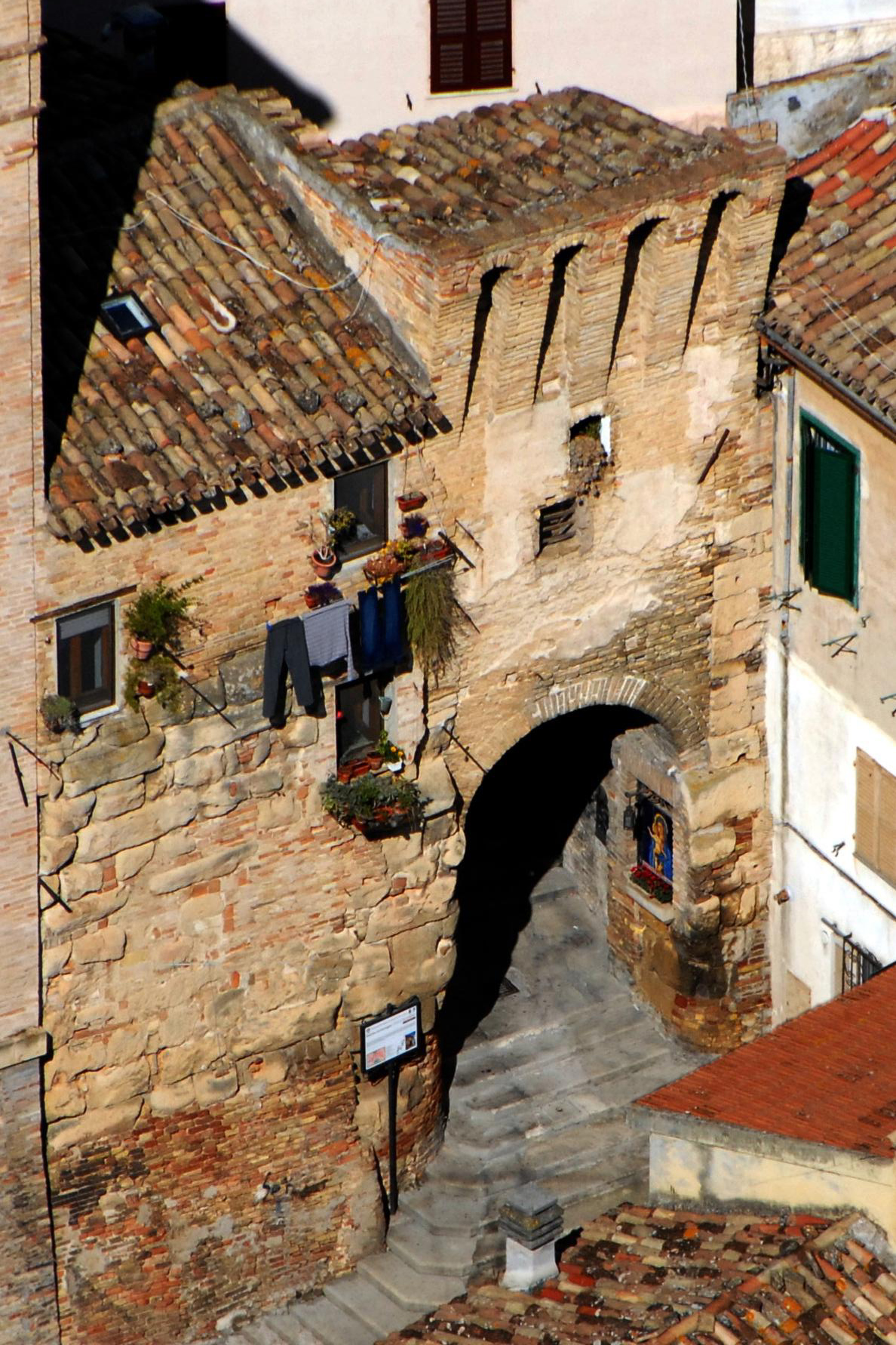
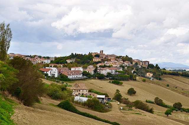
Filottrano (Filottrano)
.svg)
- Italian comune
 Hiking in Filottrano
Filottrano is a charming town located in the Marche region of Italy, surrounded by beautiful landscapes that offer various hiking opportunities. Here’s what you can expect when hiking in and around Filottrano:
Terrain and Scenery
The area is characterized by rolling hills, vineyards, lush fields, and olive groves, which provide a picturesque backdrop for hikes. The trails often offer stunning views of the surrounding countryside and are ideal for both novice and experienced hikers.
Trails
-
Local trails: You can find a number of local trails that range from easy to moderate, providing options for different skill levels. Many of these trails meander through the countryside and allow you to experience the rural charm of the Marche region.
-
Conero Regional Park: Located a bit further away, this park features more challenging hikes with breathtaking views of the Adriatic Sea. It's worth the trip if you're looking to extend your hiking experience.
-
Historical routes: Some trails in the area may take you past historical sites, including ancient churches and rural estates, giving a cultural dimension to your hike.
Best Times to Hike
- Spring (April to June): The weather is typically mild and the landscape is lush, making it an ideal time for hiking.
- Autumn (September to October): The fall foliage adds an extra layer of beauty and the temperatures are comfortable for outdoor activities.
- Summer: It can be hot, so early morning or late afternoon hikes are preferable to avoid the midday heat.
- Winter: Hiking is possible but can be more challenging due to weather conditions.
Tips
- Gear: Wear suitable hiking shoes, carry a map or GPS device, and don’t forget to bring plenty of water and snacks.
- Local Regulations: Familiarize yourself with local regulations regarding trail use, especially if you're venturing into protected areas.
- Guided Tours: If you're unsure about the trails or prefer a more structured experience, consider joining a guided hiking tour to learn more about the local flora, fauna, and historical significance of the area.
Hiking around Filottrano can be a rewarding experience, allowing you to connect with nature while enjoying the rich culture and history of the Marche region. Enjoy your hike!
- Country:

- Postal Code: 60024
- Local Dialing Code: 071
- Licence Plate Code: AN
- Coordinates: 43° 26' 4" N, 13° 21' 1" E


- GPS tracks (wikiloc): [Link]
- AboveSeaLevel: 270 м m
- Area: 71.2 sq km
- Population: 9332
- Web site: http://www.comune.filottrano.an.it/
- Wikipedia en: wiki(en)
- Wikipedia: wiki(it)
- Wikidata storage: Wikidata: Q124029
- Wikipedia Commons Category: [Link]
- Freebase ID: [/m/0gl5ql]
- GeoNames ID: Alt: [6536778]
- VIAF ID: Alt: [154949762]
- OSM relation ID: [42438]
- MusicBrainz area ID: [5e273a8d-59b1-4ae7-99b7-f26ff6a49483]
- WOEID: [715476]
- UN/LOCODE: [ITZIU]
- ISTAT ID: 042019
- Italian cadastre code: D597
Shares border with regions:

Osimo
- Italian comune
Hiking in Osimo
Osimo is a charming town in the Marche region of Italy, known for its rich history, beautiful architecture, and stunning landscapes. While it may not be as famous as some other hiking destinations, the surrounding areas offer a variety of hiking opportunities that can cater to different skill levels....
- Country:
- Postal Code: 60027
- Local Dialing Code: 071
- Licence Plate Code: AN
- Coordinates: 43° 29' 10" N, 13° 28' 56" E
- GPS tracks (wikiloc): [Link]
- AboveSeaLevel: 265 м m
- Area: 106.74 sq km
- Population: 35071
- Web site: [Link]

Santa Maria Nuova, Marche
- Italian comune
Hiking in Santa Maria Nuova, Marche
Santa Maria Nuova, located in the Marche region of Italy, is surrounded by beautiful landscapes perfect for hiking enthusiasts. The area offers a combination of rolling hills, picturesque valleys, and a chance to explore historical and cultural landmarks....
- Country:
- Postal Code: 60030
- Local Dialing Code: 0731
- Licence Plate Code: AN
- Coordinates: 43° 29' 45" N, 13° 18' 39" E
- GPS tracks (wikiloc): [Link]
- AboveSeaLevel: 249 м m
- Area: 18.29 sq km
- Population: 4146
- Web site: [Link]


Iesi
- Italian comune
Hiking in Iesi
Iesi, located in the Marche region of Italy, offers a variety of hiking opportunities with its scenic landscapes, historical sites, and charming countryside. Here are some highlights and tips for hiking in and around Iesi:...
- Country:
- Postal Code: 60035
- Local Dialing Code: 0731
- Licence Plate Code: AN
- Coordinates: 43° 31' 22" N, 13° 14' 38" E
- GPS tracks (wikiloc): [Link]
- AboveSeaLevel: 97 м m
- Area: 107.73 sq km
- Population: 40210
- Web site: [Link]


Cingoli
- Italian comune
Hiking in Cingoli
Cingoli, often referred to as the "Balcony of the Marche," is located in the Marche region of Italy. The area is known for its breathtaking landscapes, rolling hills, and expansive views of the surrounding countryside, making it a great destination for hiking enthusiasts....
- Country:
- Postal Code: 62011
- Local Dialing Code: 0733
- Licence Plate Code: MC
- Coordinates: 43° 22' 27" N, 13° 12' 59" E
- GPS tracks (wikiloc): [Link]
- AboveSeaLevel: 631 м m
- Area: 148.2 sq km
- Population: 10119
- Web site: [Link]


Appignano
- Italian comune
Hiking in Appignano
Appignano, located in the Marche region of Italy, offers a charming backdrop for hiking enthusiasts. Nestled in the rolling hills, it provides various trails that showcase the natural beauty of the area, including vineyards, olive groves, and scenic views of the surrounding countryside....
- Country:
- Postal Code: 62010
- Local Dialing Code: 0733
- Licence Plate Code: MC
- Coordinates: 43° 21' 46" N, 13° 20' 52" E
- GPS tracks (wikiloc): [Link]
- AboveSeaLevel: 199 м m
- Area: 22.67 sq km
- Population: 4195
- Web site: [Link]


Montefano
- Italian comune
Hiking in Montefano
Montefano is a charming municipality located in the Marche region of Italy, known for its beautiful landscapes, rich history, and opportunities for outdoor activities, including hiking. Here are some key points to consider if you're planning a hiking trip in the Montefano area:...
- Country:
- Postal Code: 62010
- Local Dialing Code: 0733
- Licence Plate Code: MC
- Coordinates: 43° 24' 42" N, 13° 26' 19" E
- GPS tracks (wikiloc): [Link]
- AboveSeaLevel: 242 м m
- Area: 33.94 sq km
- Population: 3458
- Web site: [Link]