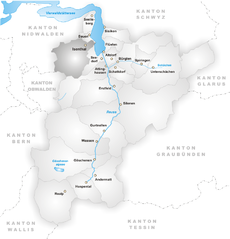
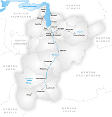
Flüelen (Flüelen)
- municipality in Switzerland
Flüelen, located in the Canton of Uri in Switzerland, offers beautiful hiking opportunities that showcase the stunning landscapes of the Swiss Alps and the shores of Lake Uri. Here are some highlights and tips for hiking in the Flüelen area:
Scenic Trails
-
Lake Uri Trail: This trail follows the shores of Lake Uri and provides breathtaking views of the water and surrounding mountains. It's a relatively easy hike, perfect for families and those looking for a leisurely experience.
-
Flüelen to Seelisberg: This moderate hike connects Flüelen to the village of Seelisberg. The trail features beautiful views of Lake Uri and the surrounding peaks. There are some inclines, but the scenery is well worth the effort.
-
Mount Rigi: While a bit further from Flüelen, hiking up Mount Rigi is a popular choice. Known as the "Queen of the Mountains," it offers panoramic views and various hiking routes of differing difficulty.
-
Brunnen to Flüelen: This is a stunning lakeside trail that connects the two towns. The path along the lake is picturesque, ideal for hiking and also for biking.
Preparation Tips
- Weather: Always check the weather forecast before heading out, as conditions can change rapidly in the mountains.
- Gear: Wear appropriate hiking shoes and carry essentials like water, snacks, a first aid kit, and a map or GPS device.
- Timing: Start your hikes early in the day to make the most of daylight hours, especially on longer trails.
- Local Information: Consider stopping by the local tourist information center for trail maps and advice on current trail conditions.
Other Activities
Besides hiking, Flüelen is a great launching point for various outdoor activities, including boating on Lake Uri and exploring nearby historical sites such as the Tell Chapel and the Swiss Transport Museum in Lucerne.
Safety Considerations
- Familiarize yourself with the terrain and difficulty of your chosen trails.
- Hiking with a partner or group is recommended, especially on more remote trails.
- Always inform someone about your hiking plans.
Overall, hiking in Flüelen is a wonderful way to experience the natural beauty of Switzerland, with a variety of trails catering to different skill levels and preferences. Enjoy your adventure!
- Country:

- Postal Code: 6454
- Local Dialing Code: 041
- Licence Plate Code: UR
- Coordinates: 46° 53' 59" N, 8° 37' 25" E


- GPS tracks (wikiloc): [Link]
- AboveSeaLevel: 435 м m
- Area: 12.42 sq km
- Population: 1975
- Web site: http://www.fluelen.ch
- Wikipedia en: wiki(en)
- Wikipedia: wiki(de)
- Wikidata storage: Wikidata: Q69665
- Wikipedia Commons Category: [Link]
- Freebase ID: [/m/0fwq3j]
- GeoNames ID: Alt: [7285841]
- VIAF ID: Alt: [234772339]
- OSM relation ID: [1683072]
- archINFORM location ID: [12750]
- HDS ID: [696]
- Swiss municipality code: [1207]
Shares border with regions:


Isenthal
- municipality in Switzerland
Isenthal is a beautiful valley located in the heart of Switzerland, specifically in the canton of Uri. It is known for its stunning landscapes, lush meadows, and impressive mountain views, making it a perfect destination for hiking enthusiasts. Here are some key highlights and tips for hiking in Isenthal:...
- Country:

- Postal Code: 6461
- Local Dialing Code: 041
- Licence Plate Code: UR
- Coordinates: 46° 53' 11" N, 8° 31' 28" E


- GPS tracks (wikiloc): [Link]
- AboveSeaLevel: 1404 м m
- Area: 60.99 sq km
- Population: 494
- Web site: [Link]


Sisikon
- municipality in Switzerland
Sisikon, located in the picturesque canton of Uri in Switzerland, is a fantastic destination for hiking enthusiasts. Nestled at the shores of Lake Lucerne amid stunning mountains, Sisikon offers a variety of trails that cater to different skill levels....
- Country:

- Postal Code: 6452
- Local Dialing Code: 041
- Licence Plate Code: UR
- Coordinates: 46° 56' 6" N, 8° 39' 39" E


- GPS tracks (wikiloc): [Link]
- AboveSeaLevel: 1497 м m
- Area: 16.29 sq km
- Population: 364
- Web site: [Link]


Altdorf
- capital of the canton of Uri, Switzerland
Altdorf, located in the Uri canton of Switzerland, is an excellent destination for hiking enthusiasts. Nestled between stunning mountains and picturesque landscapes, Altdorf offers a variety of hiking trails suitable for different skill levels, from easy walks to challenging mountain hikes....
- Country:

- Postal Code: 6460
- Local Dialing Code: 041
- Licence Plate Code: UR
- Coordinates: 46° 52' 50" N, 8° 38' 22" E


- GPS tracks (wikiloc): [Link]
- AboveSeaLevel: 458 м m
- Area: 10.23 sq km
- Population: 9273
- Web site: [Link]


Bauen
- municipality in the canton of Uri, Switzerland
Bauen is a picturesque village located in the canton of Uri in Switzerland, nestled along the shores of Lake Uri and surrounded by stunning mountain landscapes. It offers a variety of hiking opportunities for outdoor enthusiasts of all skill levels. Here’s what you need to know about hiking in Bauen:...
- Country:

- Postal Code: 6466
- Local Dialing Code: 041
- Licence Plate Code: UR
- Coordinates: 46° 56' 10" N, 8° 34' 46" E


- GPS tracks (wikiloc): [Link]
- AboveSeaLevel: 436 м m
- Area: 3.78 sq km
- Population: 168
- Web site: [Link]


Bürglen
- municipality in the canton of Uri, Switzerland
Bürglen is a picturesque village located in the Uri region of Switzerland, surrounded by stunning alpine landscapes and rich cultural history. The area is perfect for hiking enthusiasts, offering a variety of trails that cater to different skill levels....
- Country:

- Postal Code: 6463
- Local Dialing Code: 041
- Licence Plate Code: UR
- Coordinates: 46° 52' 30" N, 8° 39' 46" E


- GPS tracks (wikiloc): [Link]
- AboveSeaLevel: 525 м m
- Area: 53.14 sq km
- Population: 3982
- Web site: [Link]


Seedorf
- municipality in the canton of Uri, Switzerland
Seedorf is a charming village located in the Uri canton of Switzerland, nestled in the beautiful Reuss Valley. The region is known for its stunning landscapes, mountains, and lakes, making it an excellent destination for hiking enthusiasts....
- Country:

- Postal Code: 6462
- Local Dialing Code: 041
- Licence Plate Code: UR
- Coordinates: 46° 52' 58" N, 8° 36' 47" E


- GPS tracks (wikiloc): [Link]
- AboveSeaLevel: 452 м m
- Area: 15.64 sq km
- Population: 1804
- Web site: [Link]

