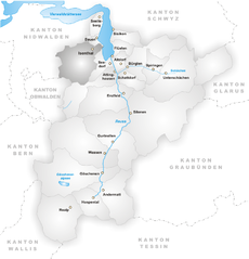
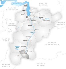
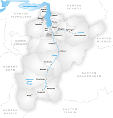
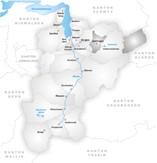
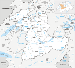
Uri (Kanton Uri)


- canton of Switzerland
 Hiking in Uri
The Canton of Uri, situated in central Switzerland, offers stunning landscapes and a range of hiking opportunities for all skill levels. Here’s a general overview of hiking in this picturesque region:
Scenic Trails
-
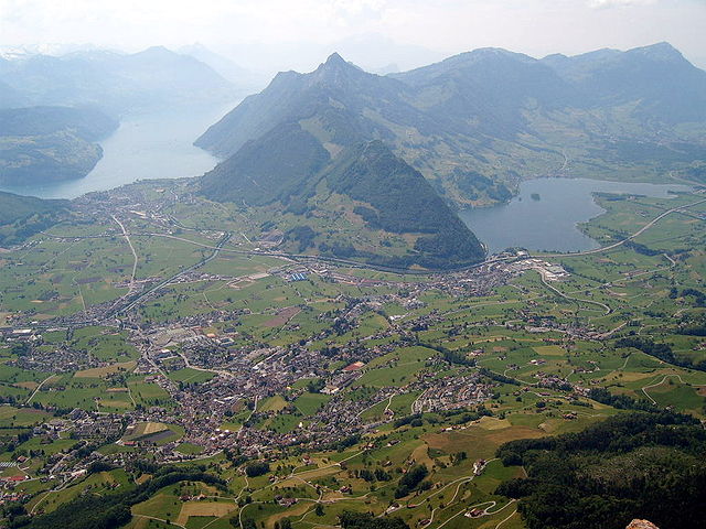
Klingenstock to Fronalpstock: This panoramic hike provides breathtaking views of Lake Lucerne, the surrounding peaks, and the Swiss Alps. The route is well-marked and is suitable for hikers of intermediate skill.
-
Aeschbach Trail: A family-friendly trail offering a manageable distance with beautiful views. It is less strenuous and perfect for a leisurely hike with children.
-
Gotthard Pass: The area around the Gotthard Pass features historical routes and trails with rich cultural significance. Hikers can explore paths that were once used by traders and pilgrims, offering both scenic views and a touch of history.
-
Schächental Valley: This valley presents several hiking options with varying levels of difficulty. The region is known for its lush meadows and majestic mountains.
Seasonal Considerations
- Spring and Summer: These seasons are the most popular for hiking due to the milder temperatures and blooming flora. Make sure to check for trail accessibility, as some routes may still have snow in early spring.
- Autumn: The fall foliage in Uri can be spectacular, and the cooler temperatures make for comfortable hiking.
- Winter: Many trails are suitable for snowshoeing and winter hiking, although you should check for avalanche risks and local conditions.
Preparation Tips
- Map & Navigation: Always carry a durable map or use a hiking app to navigate the trails. Mobile reception can be patchy in some areas.
- Gear: Wear sturdy hiking boots, dress in layers, and bring rain gear. Trekking poles can also be beneficial, especially in steep or uneven terrain.
- Water & Snacks: Bring sufficient water and high-energy snacks. There may be limited access to running water on some trails.
- Safety: Inform someone about your hiking plans and estimated return time, especially when exploring less-trafficked routes.
Points of Interest
- Seedorf: A charming village that serves as a great base for starting your hikes.
- Optimistic views of the Reuss River: Hiking routes often follow the river, providing a great way to enjoy the beautiful water landscapes.
- Cultural Heritage: Along your hikes, look for local historical sites, churches, and traditional architecture that highlight the region’s rich culture.
Whether you are an experienced hiker or a beginner, the Canton of Uri is a beautiful destination that offers diverse landscapes, stunning alpine scenery, and unforgettable outdoor experiences. Always make sure to check local conditions, trail closures, and visitor centers for the latest information. Enjoy your hike!
- Country:

- Capital: Altdorf
- Licence Plate Code: UR
- Coordinates: 46° 47' 0" N, 8° 37' 0" E


- GPS tracks (wikiloc): [Link]
- AboveSeaLevel: 447 м m
- Area: 1076.57 sq km
- Population: 36145
- Web site: http://www.ur.ch/
- Wikipedia en: wiki(en)
- Wikipedia: wiki(de)
- Wikidata storage: Wikidata: Q12404
- Wikipedia Commons Gallery: [Link]
- Wikipedia Commons Category: [Link]
- Freebase ID: [/m/01hlrc]
- GeoNames ID: Alt: [2658226]
- BnF ID: [12107734j]
- VIAF ID: Alt: [124361741]
- GND ID: Alt: [4062129-7]
- archINFORM location ID: [2833]
- Library of Congress authority ID: Alt: [n82138822]
- Quora topic ID: [Canton-of-Uri]
- SUDOC authorities ID: [029453208]
- Encyclopædia Britannica Online ID: [place/Uri]
- HDS ID: [7384]
- ISNI: Alt: [0000 0001 1463 6622]
- NUTS code: [CH062]
- Klexikon article ID: [Uri]
- Ringgold ID: [322356]
- STW Thesaurus for Economics ID: [16977-5]
- ISO 3166-2 code: CH-UR
- FIPS 10-4 (countries and regions): SZ21
Includes regions:


Andermatt
- municipality in Switzerland
Hiking in Andermatt
Andermatt, nestled in the Swiss Alps, is a captivating hub for hiking enthusiasts. Known for its stunning alpine scenery, Andermatt offers a wide range of trails suitable for various skill levels, from beginners to seasoned hikers....
- Country:
- Postal Code: 6490
- Local Dialing Code: 041
- Licence Plate Code: UR
- Coordinates: 46° 37' 14" N, 8° 37' 53" E
- GPS tracks (wikiloc): [Link]
- AboveSeaLevel: 1753 м m
- Area: 62.2 sq km
- Population: 1354
- Web site: [Link]


Seelisberg
- municipality in Switzerland
Hiking in Seelisberg
Seelisberg is a picturesque village located in the Uri region of Switzerland, known for its stunning views of Lake Lucerne and the surrounding mountains. It offers a variety of hiking trails suitable for different skill levels, making it an excellent destination for both novice and experienced hikers....
- Country:
- Postal Code: 6377
- Local Dialing Code: 041
- Licence Plate Code: UR
- Coordinates: 46° 57' 29" N, 8° 34' 21" E
- GPS tracks (wikiloc): [Link]
- AboveSeaLevel: 736 м m
- Area: 13.34 sq km
- Population: 679
- Web site: [Link]


Gurtnellen
- municipality in Switzerland
Hiking in Gurtnellen
Gurtnellen, located in the picturesque Uri region of Switzerland, is a great destination for hiking enthusiasts. Nestled in the heart of the Swiss Alps, it offers stunning views, varied terrain, and a range of hiking trails suited for different skill levels....
- Country:
- Postal Code: 6482
- Local Dialing Code: 041
- Licence Plate Code: UR
- Coordinates: 46° 44' 37" N, 8° 37' 26" E
- GPS tracks (wikiloc): [Link]
- AboveSeaLevel: 1104 м m
- Area: 83.35 sq km
- Population: 558
- Web site: [Link]

Isenthal
- municipality in Switzerland
Hiking in Isenthal
Isenthal is a beautiful valley located in the heart of Switzerland, specifically in the canton of Uri. It is known for its stunning landscapes, lush meadows, and impressive mountain views, making it a perfect destination for hiking enthusiasts. Here are some key highlights and tips for hiking in Isenthal:...
- Country:
- Postal Code: 6461
- Local Dialing Code: 041
- Licence Plate Code: UR
- Coordinates: 46° 53' 11" N, 8° 31' 28" E
- GPS tracks (wikiloc): [Link]
- AboveSeaLevel: 1404 м m
- Area: 60.99 sq km
- Population: 494
- Web site: [Link]

Hospental
- municipality in Switzerland
Hiking in Hospental
Hospental is a picturesque village located in the Ursern Valley of the Swiss canton of Uri, nestled within the stunning landscapes of the Swiss Alps. Hiking in and around Hospental offers a range of options for all ability levels, from easy, family-friendly trails to more challenging alpine hikes. Here are some highlights and tips about hiking in this beautiful region:...
- Country:
- Postal Code: 6493
- Local Dialing Code: 041
- Licence Plate Code: UR
- Coordinates: 46° 37' 14" N, 8° 34' 12" E
- GPS tracks (wikiloc): [Link]
- AboveSeaLevel: 1493 м m
- Area: 35.0 sq km
- Population: 191
- Web site: [Link]


Unterschächen
- municipality in Switzerland
Hiking in Unterschächen
Unterschächen is a picturesque village located in the heart of the Swiss Alps, specifically in the canton of Uri. It's a great destination for hiking enthusiasts due to its stunning mountain scenery and a variety of trails suitable for different skill levels....
- Country:
- Postal Code: 6465
- Local Dialing Code: 041
- Licence Plate Code: UR
- Coordinates: 46° 51' 30" N, 8° 47' 37" E
- GPS tracks (wikiloc): [Link]
- AboveSeaLevel: 1552 м m
- Area: 80.33 sq km
- Population: 714
- Web site: [Link]


Schattdorf
- municipality in Switzerland
Hiking in Schattdorf
Schattdorf is a charming village located in the Canton of Uri in Switzerland, surrounded by stunning mountain landscapes, making it an excellent destination for hiking enthusiasts. Here are some highlights and tips for hiking in this area:...
- Country:
- Postal Code: 6467
- Local Dialing Code: 041
- Licence Plate Code: UR
- Coordinates: 46° 50' 58" N, 8° 40' 17" E
- GPS tracks (wikiloc): [Link]
- AboveSeaLevel: 1190 м m
- Area: 16.31 sq km
- Population: 5382
- Web site: [Link]


Sisikon
- municipality in Switzerland
Hiking in Sisikon
Sisikon, located in the picturesque canton of Uri in Switzerland, is a fantastic destination for hiking enthusiasts. Nestled at the shores of Lake Lucerne amid stunning mountains, Sisikon offers a variety of trails that cater to different skill levels....
- Country:
- Postal Code: 6452
- Local Dialing Code: 041
- Licence Plate Code: UR
- Coordinates: 46° 56' 6" N, 8° 39' 39" E
- GPS tracks (wikiloc): [Link]
- AboveSeaLevel: 1497 м m
- Area: 16.29 sq km
- Population: 364
- Web site: [Link]


Realp
- municipality in Switzerland
Hiking in Realp
Realp is a charming village located in the Uri canton of Switzerland, nestled in the heart of the Swiss Alps. It's an excellent destination for hiking enthusiasts, offering a variety of trails that cater to different skill levels and preferences. Here are some highlights for hiking in and around Realp:...
- Country:
- Postal Code: 6491
- Local Dialing Code: 041
- Licence Plate Code: UR
- Coordinates: 46° 35' 55" N, 8° 30' 11" E
- GPS tracks (wikiloc): [Link]
- AboveSeaLevel: 1538 м m
- Area: 78.04 sq km
- Population: 151
- Web site: [Link]

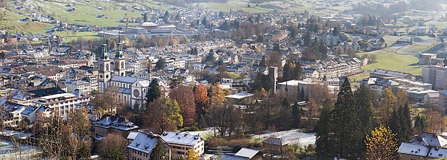
Altdorf
- capital of the canton of Uri, Switzerland
Hiking in Altdorf
Altdorf, located in the Uri canton of Switzerland, is an excellent destination for hiking enthusiasts. Nestled between stunning mountains and picturesque landscapes, Altdorf offers a variety of hiking trails suitable for different skill levels, from easy walks to challenging mountain hikes....
- Country:
- Postal Code: 6460
- Local Dialing Code: 041
- Licence Plate Code: UR
- Coordinates: 46° 52' 50" N, 8° 38' 22" E
- GPS tracks (wikiloc): [Link]
- AboveSeaLevel: 458 м m
- Area: 10.23 sq km
- Population: 9273
- Web site: [Link]

Silenen
- municipality in the canton of Uri, Switzerland
Hiking in Silenen
Silenen, a charming municipality in the canton of Uri, Switzerland, is an excellent destination for hiking enthusiasts. Nestled in a picturesque valley, Silenen offers breathtaking views of the surrounding mountains and is a great starting point for various hiking trails suitable for all levels of experience....
- Country:
- Postal Code: 6473
- Local Dialing Code: 041
- Licence Plate Code: UR
- Coordinates: 46° 47' 28" N, 8° 40' 9" E
- GPS tracks (wikiloc): [Link]
- AboveSeaLevel: 510 м m
- Area: 144.78 sq km
- Population: 1991
- Web site: [Link]

Attinghausen
- municipality in Switzerland
Hiking in Attinghausen
Attinghausen is a charming village located in the Canton of Uri, Switzerland, surrounded by stunning alpine landscapes and offering a variety of hiking opportunities. Here are some highlights for hiking in and around Attinghausen:...
- Country:
- Postal Code: 6468
- Local Dialing Code: 041
- Licence Plate Code: UR
- Coordinates: 46° 49' 42" N, 8° 32' 37" E
- GPS tracks (wikiloc): [Link]
- AboveSeaLevel: 2109 м m
- Area: 46.83 sq km
- Population: 1711
- Web site: [Link]

Bauen
- municipality in the canton of Uri, Switzerland
Hiking in Bauen
Bauen is a picturesque village located in the canton of Uri in Switzerland, nestled along the shores of Lake Uri and surrounded by stunning mountain landscapes. It offers a variety of hiking opportunities for outdoor enthusiasts of all skill levels. Here’s what you need to know about hiking in Bauen:...
- Country:
- Postal Code: 6466
- Local Dialing Code: 041
- Licence Plate Code: UR
- Coordinates: 46° 56' 10" N, 8° 34' 46" E
- GPS tracks (wikiloc): [Link]
- AboveSeaLevel: 436 м m
- Area: 3.78 sq km
- Population: 168
- Web site: [Link]


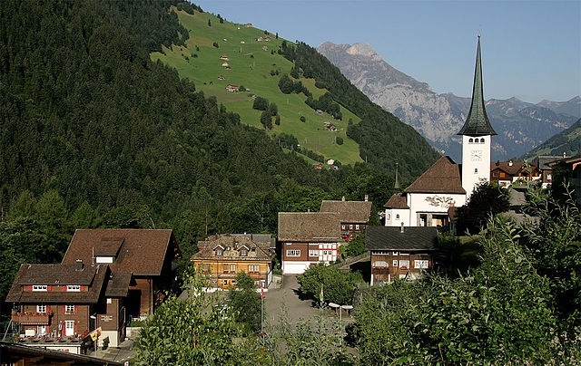
Bürglen
- municipality in the canton of Uri, Switzerland
Hiking in Bürglen
Bürglen is a picturesque village located in the Uri region of Switzerland, surrounded by stunning alpine landscapes and rich cultural history. The area is perfect for hiking enthusiasts, offering a variety of trails that cater to different skill levels....
- Country:
- Postal Code: 6463
- Local Dialing Code: 041
- Licence Plate Code: UR
- Coordinates: 46° 52' 30" N, 8° 39' 46" E
- GPS tracks (wikiloc): [Link]
- AboveSeaLevel: 525 м m
- Area: 53.14 sq km
- Population: 3982
- Web site: [Link]


Wassen
- municipality in Switzerland
Hiking in Wassen
Wassen, located in the beautiful Swiss canton of Uri, is a charming village that serves as a gateway to stunning alpine landscapes and diverse hiking trails. The region is known for its breathtaking mountain scenery, lush meadows, and rich cultural heritage....
- Country:
- Postal Code: 6484
- Local Dialing Code: 041
- Licence Plate Code: UR
- Coordinates: 46° 43' 29" N, 8° 32' 0" E
- GPS tracks (wikiloc): [Link]
- AboveSeaLevel: 1889 м m
- Area: 96.89 sq km
- Population: 422
- Web site: [Link]


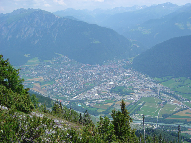
Göschenen
- Village and municipality in Switzerland
Hiking in Göschenen
Göschenen is a picturesque village in the Uri canton of Switzerland, located at the entrance to the Gotthard region, and it offers a variety of hiking opportunities for outdoor enthusiasts. Here are some highlights:...
- Country:
- Postal Code: 6487
- Local Dialing Code: 041
- Licence Plate Code: UR
- Coordinates: 46° 39' 50" N, 8° 29' 56" E
- GPS tracks (wikiloc): [Link]
- AboveSeaLevel: 2430 м m
- Area: 10431 sq km
- Population: 462
- Web site: [Link]


Erstfeld
- municipality in Switzerland
Hiking in Erstfeld
Erstfeld, located in the canton of Uri in Switzerland, is an excellent destination for hiking enthusiasts. The region is known for its stunning alpine scenery, charming villages, and diverse trails that cater to various skill levels. Here are some highlights of hiking in Erstfeld:...
- Country:
- Postal Code: 6472
- Local Dialing Code: 041
- Licence Plate Code: UR
- Coordinates: 46° 48' 45" N, 8° 35' 58" E
- GPS tracks (wikiloc): [Link]
- AboveSeaLevel: 1067 м m
- Area: 59.2 sq km
- Population: 3781
- Web site: [Link]
Spiringen
- municipality in Switzerland
Hiking in Spiringen
Spiringen is a picturesque village located in the Canton of Uri, Switzerland, and is a great destination for hiking enthusiasts. Nestled in the Urner Valley, it offers stunning views of the surrounding mountains and has access to a variety of hiking trails suitable for different skill levels....
- Country:
- Postal Code: 8751; 6464
- Local Dialing Code: 041
- Licence Plate Code: UR
- Coordinates: 46° 52' 42" N, 8° 50' 37" E
- GPS tracks (wikiloc): [Link]
- AboveSeaLevel: 2267 м m
- Area: 64.73 sq km
- Population: 843
- Web site: [Link]


Flüelen
- municipality in Switzerland
Hiking in Flüelen
Flüelen, located in the Canton of Uri in Switzerland, offers beautiful hiking opportunities that showcase the stunning landscapes of the Swiss Alps and the shores of Lake Uri. Here are some highlights and tips for hiking in the Flüelen area:...
- Country:
- Postal Code: 6454
- Local Dialing Code: 041
- Licence Plate Code: UR
- Coordinates: 46° 53' 59" N, 8° 37' 25" E
- GPS tracks (wikiloc): [Link]
- AboveSeaLevel: 435 м m
- Area: 12.42 sq km
- Population: 1975
- Web site: [Link]


Seedorf
- municipality in the canton of Uri, Switzerland
Hiking in Seedorf
Seedorf is a charming village located in the Uri canton of Switzerland, nestled in the beautiful Reuss Valley. The region is known for its stunning landscapes, mountains, and lakes, making it an excellent destination for hiking enthusiasts....
- Country:
- Postal Code: 6462
- Local Dialing Code: 041
- Licence Plate Code: UR
- Coordinates: 46° 52' 58" N, 8° 36' 47" E
- GPS tracks (wikiloc): [Link]
- AboveSeaLevel: 452 м m
- Area: 15.64 sq km
- Population: 1804
- Web site: [Link]
Shares border with regions:

canton of Bern
- canton of Switzerland
Hiking in canton of Bern
The Canton of Bern, located in Switzerland, offers some of the most stunning landscapes and diverse trails for hiking enthusiasts. This region boasts a mix of alpine scenery, picturesque villages, and lush valleys, making it an excellent destination for all levels of hikers. Here are some highlights you can expect when hiking in the Canton of Bern:...
- Country:
- Capital: Bern
- Licence Plate Code: BE
- Coordinates: 46° 50' 0" N, 7° 37' 0" E
- GPS tracks (wikiloc): [Link]
- AboveSeaLevel: 542 м m
- Area: 5959 sq km
- Population: 1031126
- Web site: [Link]
Glarus
- canton of Switzerland
Hiking in Glarus
The Canton of Glarus, located in central Switzerland, is a stunning destination for hikers, offering a variety of trails that cater to different skill levels. Nestled between the rugged Alps and picturesque valleys, the region is known for its breathtaking landscapes, diverse flora and fauna, and charming villages....
- Country:
- Capital: Glarus
- Licence Plate Code: GL
- Coordinates: 46° 59' 0" N, 9° 4' 0" E
- GPS tracks (wikiloc): [Link]
- AboveSeaLevel: 472 м m
- Area: 685.3 sq km
- Population: 40000
- Web site: [Link]
Graubünden
- canton of Switzerland
Hiking in Graubünden
The Canton of Grisons, or Graubünden, is a breathtaking region in Switzerland known for its stunning landscapes, diverse hiking trails, and rich cultural heritage. Here are some highlights of hiking in this beautiful area:...
- Country:
- Capital: Chur
- Licence Plate Code: GR
- Coordinates: 46° 45' 0" N, 9° 30' 0" E
- GPS tracks (wikiloc): [Link]
- AboveSeaLevel: 585 м m
- Area: 7105.39 sq km
- Web site: [Link]

Schwyz
- canton of Switzerland
Hiking in Schwyz
Hiking in the Canton of Schwyz in Switzerland offers a fantastic blend of stunning landscapes, rich cultural history, and well-maintained trails. The region features a variety of terrains, including mountains, lakes, and picturesque villages, making it a great destination for both novice and experienced hikers....
- Country:
- Capital: Schwyz
- Licence Plate Code: SZ
- Coordinates: 47° 4' 0" N, 8° 45' 0" E
- GPS tracks (wikiloc): [Link]
- AboveSeaLevel: 516 м m
- Area: 907.88 sq km
- Population: 155863
- Web site: [Link]

Obwalden
- canton of Switzerland
Hiking in Obwalden
The Canton of Obwalden, located in central Switzerland, is a spectacular area for hiking, characterized by its stunning Alpine landscapes, lush green valleys, and clear lakes. Here are some key highlights and tips for hiking in this beautiful canton:...
- Country:
- Capital: Sarnen
- Licence Plate Code: OW
- Coordinates: 46° 52' 0" N, 8° 2' 0" E
- GPS tracks (wikiloc): [Link]
- AboveSeaLevel: 473 м m
- Area: 490.58 sq km
- Population: 37378
- Web site: [Link]

Nidwalden
- canton of Switzerland
Hiking in Nidwalden
The Canton of Nidwalden, located in central Switzerland, is a true paradise for hikers, offering breathtaking landscapes, diverse trails, and stunning vistas of the surrounding mountains and lakes. Here are some highlights and points of interest for hiking in this beautiful region:...
- Country:
- Capital: Stans
- Licence Plate Code: NW
- Coordinates: 46° 56' 0" N, 8° 4' 0" E
- GPS tracks (wikiloc): [Link]
- AboveSeaLevel: 454 м m
- Area: 275.85 sq km
- Web site: [Link]


Ticino
- canton of Switzerland
Hiking in Ticino
The Canton of Ticino, located in southern Switzerland, is a breathtaking destination for hiking enthusiasts. Known for its stunning landscapes, picturesque villages, and mild Mediterranean climate, Ticino offers a variety of trails suitable for all levels of hikers. Here are some highlights:...
- Country:
- Capital: Chiasso
- Local Dialing Code: 091
- Licence Plate Code: TI
- Coordinates: 46° 19' 0" N, 8° 49' 0" E
- GPS tracks (wikiloc): [Link]
- AboveSeaLevel: 238 м m
- Area: 2812.15 sq km
- Web site: [Link]


Canton of Valais
- canton of Switzerland
Hiking in Canton of Valais
The Canton of Valais, located in southwestern Switzerland, is a fantastic destination for hiking enthusiasts. Famous for its stunning landscapes dominated by the Alps, the region offers a wide variety of trails suitable for all levels of hikers. Here are some key points to know about hiking in Valais:...
- Country:
- Capital: Sion
- Licence Plate Code: VS
- Coordinates: 46° 4' 0" N, 7° 36' 0" E
- GPS tracks (wikiloc): [Link]
- AboveSeaLevel: 512 м m
- Area: 5224.50 sq km
- Web site: [Link]