Flassigny (Flassigny)

- commune in Meuse, France
- Country:

- Postal Code: 55600
- Coordinates: 49° 28' 24" N, 5° 26' 27" E


- GPS tracks (wikiloc): [Link]
- Area: 6.66 sq km
- Population: 46
- Wikipedia en: wiki(en)
- Wikipedia: wiki(fr)
- Wikidata storage: Wikidata: Q723810
- Wikipedia Commons Category: [Link]
- Freebase ID: [/m/03qdqww]
- GeoNames ID: Alt: [6437005]
- SIREN number: [215501883]
- BnF ID: [15264855w]
- INSEE municipality code: 55188
Shares border with regions:

Velosnes
- commune in Meuse, France
- Country:
- Postal Code: 55600
- Coordinates: 49° 30' 22" N, 5° 27' 18" E
- GPS tracks (wikiloc): [Link]
- Area: 4.37 sq km
- Population: 173


Villers-le-Rond
- commune in Meurthe-et-Moselle, France
- Country:
- Postal Code: 54260
- Coordinates: 49° 27' 54" N, 5° 29' 23" E
- GPS tracks (wikiloc): [Link]
- Area: 4.45 sq km
- Population: 100

Iré-le-Sec
- commune in Meuse, France
- Country:
- Postal Code: 55600
- Coordinates: 49° 28' 34" N, 5° 23' 17" E
- GPS tracks (wikiloc): [Link]
- Area: 8.31 sq km
- Population: 155


Marville
- commune in Meuse, France
- Country:
- Postal Code: 55600
- Coordinates: 49° 27' 8" N, 5° 27' 21" E
- GPS tracks (wikiloc): [Link]
- Area: 19.55 sq km
- Population: 502

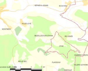
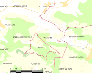
Bazeilles-sur-Othain
- commune in Meuse, France
- Country:
- Postal Code: 55600
- Coordinates: 49° 29' 48" N, 5° 25' 41" E
- GPS tracks (wikiloc): [Link]
- Area: 7.66 sq km
- Population: 118


Othe
- commune in Meurthe-et-Moselle, France
- Country:
- Postal Code: 54260
- Coordinates: 49° 29' 44" N, 5° 26' 34" E
- GPS tracks (wikiloc): [Link]
- Area: 2.97 sq km
- Population: 31