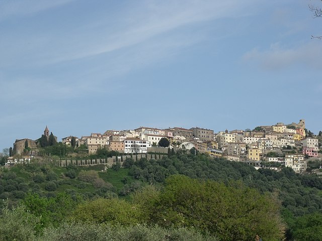
Follonica (Follonica)
.svg)
- Italian comune
 Hiking in Follonica
Follonica, located in Tuscany, Italy, is well known for its beautiful coastline and rich natural surroundings. While it is primarily recognized for its beaches and summer tourism, there are several hiking opportunities in and around the area that enthusiasts can enjoy. Here are some highlights:
1.
- Parco Nazionale delle Colline Metallifere: This national park is close to Follonica and offers a variety of trails that take you through stunning landscapes, forests, and hills. The park is known for its rich biodiversity, ancient mines, and historical sites.
- Riserva Naturale Tomboli di Follonica: This nature reserve consists of coastal pine forests and dunes. Hiking here provides a chance to explore different ecosystems and enjoy views of the Tyrrhenian Sea.
2.
- The coastline near Follonica features beautiful walking paths where you can enjoy the sea breeze and views of the Mediterranean. Trails often connect to nearby towns and offer scenic spots for breaks.
3.
- You can hike from Follonica to nearby towns like Scarlino or Massa Marittima, both which provide cultural attractions and stunning views from their elevated positions. These hikes can vary in difficulty and length, catering to different skill levels.
4.
- Consider joining a guided hiking tour, which can provide valuable insights into the local flora, fauna, and history of the area. Local guides often know hidden gems and the best spots for photography.
5.
- Weather: Check the local weather conditions before heading out, especially in the hotter months.
- Footwear: Wear sturdy, comfortable shoes suitable for hiking.
- Water and Snacks: Bring enough water and some snacks to keep your energy up during the hike.
- Map and Navigation: Make sure you have a map or GPS device, as trails can sometimes be less well marked.
Hiking in and around Follonica offers a wonderful way to experience the natural beauty of Tuscany, combining exercise and exploration with the chance to discover local culture and scenery.
- Country:

- Postal Code: 58022
- Local Dialing Code: 0566
- Licence Plate Code: GR
- Coordinates: 42° 55' 8" N, 10° 45' 41" E


- GPS tracks (wikiloc): [Link]
- AboveSeaLevel: 4 м m
- Area: 56.02 sq km
- Population: 21308
- Web site: http://www.comune.follonica.gr.it
- Wikipedia en: wiki(en)
- Wikipedia: wiki(it)
- Wikidata storage: Wikidata: Q188587
- Wikipedia Commons Gallery: [Link]
- Wikipedia Commons Category: [Link]
- Freebase ID: [/m/02ywqd]
- GeoNames ID: Alt: [6541106]
- VIAF ID: Alt: [164565685]
- OSM relation ID: [42246]
- MusicBrainz area ID: [4d31985a-2203-451e-aa8f-0826576da63a]
- Quora topic ID: [Follonica]
- UN/LOCODE: [ITFOL]
- Gran Enciclopèdia Catalana ID: [0027336]
- ISTAT ID: 053009
- Italian cadastre code: D656
Shares border with regions:


Suvereto
- Italian comune
Hiking in Suvereto
Suvereto is a charming medieval village located in the Tuscany region of Italy, known for its beautiful landscapes, historic architecture, and rich cultural heritage. The surrounding area offers excellent hiking opportunities, with trails that showcase the natural beauty of the Tuscan countryside. Here’s what you should know about hiking in and around Suvereto:...
- Country:
- Postal Code: 57028
- Local Dialing Code: 0565
- Licence Plate Code: LI
- Coordinates: 43° 5' 0" N, 10° 41' 0" E
- GPS tracks (wikiloc): [Link]
- AboveSeaLevel: 90 м m
- Area: 92.47 sq km
- Population: 3101
- Web site: [Link]


Piombino
- Italian comune
Hiking in Piombino
Piombino, located in the southern part of Tuscany, Italy, is a wonderful destination for hiking enthusiasts. It offers a mix of beautiful coastal trails, stunning landscapes, and a glimpse into the region's natural and historical heritage. Here are some highlights and tips for hiking in and around Piombino:...
- Country:
- Postal Code: 57020; 57025
- Local Dialing Code: 0565
- Licence Plate Code: LI
- Coordinates: 42° 56' 5" N, 10° 31' 20" E
- GPS tracks (wikiloc): [Link]
- AboveSeaLevel: 21 м m
- Area: 129.88 sq km
- Population: 33855
- Web site: [Link]


Massa Marittima
- Italian comune
Hiking in Massa Marittima
Massa Marittima is a charming medieval town located in Tuscany, Italy, and it's surrounded by beautiful landscapes that are ideal for hiking. The region offers a variety of trails, suitable for different skill levels, ranging from easy walks to more challenging hikes. Here are some key highlights about hiking in the area:...
- Country:
- Postal Code: 58024
- Local Dialing Code: 0566
- Licence Plate Code: GR
- Coordinates: 43° 3' 0" N, 10° 53' 37" E
- GPS tracks (wikiloc): [Link]
- AboveSeaLevel: 380 м m
- Area: 283.45 sq km
- Population: 8286
- Web site: [Link]
Scarlino
- Italian comune
Hiking in Scarlino
Scarlino, located in the Maremma region of Tuscany, Italy, is a beautiful area perfect for hiking enthusiasts. The landscape features rolling hills, Mediterranean vegetation, and stunning views of the coastline, making it a great destination for outdoor activities....
- Country:
- Postal Code: 58020
- Local Dialing Code: 0566
- Licence Plate Code: GR
- Coordinates: 42° 54' 29" N, 10° 51' 3" E
- GPS tracks (wikiloc): [Link]
- AboveSeaLevel: 229 м m
- Area: 88.29 sq km
- Population: 3884
- Web site: [Link]