Fontains (Fontains)

- commune in Seine-et-Marne, France
- Country:

- Postal Code: 77370
- Coordinates: 48° 31' 35" N, 3° 0' 3" E


- GPS tracks (wikiloc): [Link]
- Area: 14.36 sq km
- Population: 231
- Web site: http://www.mairiedefontains.fr/
- Wikipedia en: wiki(en)
- Wikipedia: wiki(fr)
- Wikidata storage: Wikidata: Q428032
- Wikipedia Commons Category: [Link]
- Freebase ID: [/m/02qh2m2]
- Freebase ID: [/m/02qh2m2]
- GeoNames ID: Alt: [6443663]
- GeoNames ID: Alt: [6443663]
- SIREN number: [217701903]
- SIREN number: [217701903]
- BnF ID: [152755305]
- BnF ID: [152755305]
- INSEE municipality code: 77190
- INSEE municipality code: 77190
Shares border with regions:


Villeneuve-les-Bordes
- commune in Seine-et-Marne, France
- Country:
- Postal Code: 77154
- Coordinates: 48° 29' 11" N, 3° 2' 34" E
- GPS tracks (wikiloc): [Link]
- Area: 20.6 sq km
- Population: 605


Nangis
- commune in Seine-et-Marne, France
- Country:
- Postal Code: 77370
- Coordinates: 48° 33' 18" N, 3° 0' 53" E
- GPS tracks (wikiloc): [Link]
- Area: 24.16 sq km
- Population: 8593
- Web site: [Link]


La Chapelle-Rablais
- commune in Seine-et-Marne, France
- Country:
- Postal Code: 77370
- Coordinates: 48° 30' 40" N, 2° 58' 18" E
- GPS tracks (wikiloc): [Link]
- Area: 15.44 sq km
- Population: 983
- Web site: [Link]

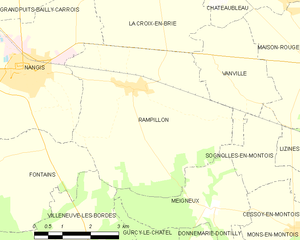
Rampillon
- commune in Seine-et-Marne, France
- Country:
- Postal Code: 77370
- Coordinates: 48° 32' 59" N, 3° 3' 58" E
- GPS tracks (wikiloc): [Link]
- Area: 23.12 sq km
- Population: 819