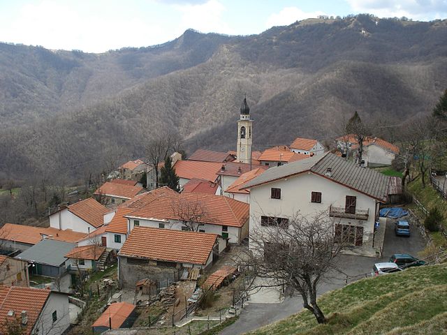
Fontanigorda (Fontanigorda)
- Italian comune
Fontanigorda is a charming village located in the Apennine Mountains of northern Italy, and it offers a variety of hiking opportunities for outdoor enthusiasts. The area is characterized by its lush forests, scenic landscapes, and rich biodiversity, making it an ideal location for hikers looking to explore nature.
Hiking Trails
-
Sentiero degli Olivi: This trail leads you through olive groves and offers stunning views of the surrounding valleys. It’s relatively easy and suitable for families or beginners.
-
Monte Penna: A more challenging hike, this trail takes you to the summit of Monte Penna, where you can enjoy panoramic views. It’s recommended for those with some hiking experience and good fitness levels.
-
Natural Pathways: There are several well-marked paths around Fontanigorda, some of which connect to the larger network of trails in the surrounding areas, including routes that lead to neighboring villages.
-
Flora and Fauna Observation: The region is known for its flora and fauna, so take your time to explore and appreciate the wildlife. Birdwatching and wildflower spotting can be particularly rewarding in spring.
Hiking Tips
- Preparation: Always check the weather forecast before heading out and be prepared for sudden changes in weather, especially in the mountains.
- Gear: Wear sturdy hiking boots, and dress in layers to adjust to changing temperatures. Don’t forget essentials like water, snacks, a first-aid kit, and a map or GPS device.
- Local Regulations: Be aware of any local regulations regarding trails, wildlife, and camping (if necessary). Leave no trace to preserve the natural beauty of the area.
- Guided Tours: If you’re unfamiliar with the area or prefer to have a local guide, consider joining a guided hike which can offer additional insights into the area's history and ecology.
Best Time to Hike
The best time to hike in Fontanigorda is typically from late spring (May) to early fall (September), as the weather is more favorable for outdoor activities. In summer, be prepared for warm temperatures, while spring and early fall can offer milder conditions.
Conclusion
Fontanigorda is a fantastic destination for hiking, with its diverse trails catering to various skill levels. Whether you're looking for a leisurely stroll or a challenging ascent, the area's natural beauty will surely make your hiking experience memorable.
- Country:

- Postal Code: 16023
- Local Dialing Code: 010
- Licence Plate Code: GE
- Coordinates: 44° 32' 48" N, 9° 18' 17" E


- GPS tracks (wikiloc): [Link]
- AboveSeaLevel: 800 м m
- Area: 16.16 sq km
- Population: 264
- Web site: http://www.comune.fontanigorda.ge.it/
- Wikipedia en: wiki(en)
- Wikipedia: wiki(it)
- Wikidata storage: Wikidata: Q266326
- Wikipedia Commons Category: [Link]
- Freebase ID: [/m/0ghw84]
- GeoNames ID: Alt: [6540148]
- OSM relation ID: [43269]
- ISTAT ID: 010024
- Italian cadastre code: D677
Shares border with regions:


Fascia, Liguria
- Italian comune
Fascia is a charming commune in the Liguria region of Italy, nestled in the hills above the Gulf of Genoa. While it’s not as widely known as other hiking destinations in Liguria, its scenic landscapes and proximity to the Ligurian Apennines make it a great option for those looking to explore the less-traveled paths of the Italian countryside....
- Country:

- Postal Code: 16020
- Local Dialing Code: 010
- Licence Plate Code: GE
- Coordinates: 44° 33' 57" N, 9° 14' 15" E


- GPS tracks (wikiloc): [Link]
- AboveSeaLevel: 900 м m
- Area: 11.25 sq km
- Population: 71
- Web site: [Link]


Montebruno
- Italian comune
Montebruno is a charming destination for hikers located in the Liguria region of Italy, known for its picturesque landscapes, lush greenery, and scenic trails. Here’s what you should know about hiking in Montebruno:...
- Country:

- Postal Code: 16025
- Local Dialing Code: 010
- Licence Plate Code: GE
- Coordinates: 44° 31' 34" N, 9° 14' 56" E


- GPS tracks (wikiloc): [Link]
- AboveSeaLevel: 655 м m
- Area: 17.68 sq km
- Population: 231
- Web site: [Link]


Rovegno
- Italian comune
Rovegno is a beautiful destination for hiking enthusiasts, located in the heart of the Italian Apennines in the Liguria region. This area offers a range of hiking trails that cater to various skill levels, and it is known for its stunning landscapes, rich biodiversity, and charming local culture....
- Country:

- Postal Code: 16028
- Local Dialing Code: 010
- Licence Plate Code: GE
- Coordinates: 44° 34' 33" N, 9° 16' 44" E


- GPS tracks (wikiloc): [Link]
- AboveSeaLevel: 658 м m
- Area: 44.09 sq km
- Population: 511
- Web site: [Link]


Rezzoaglio
- Italian comune
Rezzoaglio is a picturesque area located in the Liguria region of Italy, surrounded by the Apennine Mountains. It's an excellent destination for hikers due to its diverse landscapes, including lush forests, stunning valleys, and panoramic views. Here are some highlights and tips for hiking in Rezzoaglio:...
- Country:

- Postal Code: 16048
- Local Dialing Code: 0185
- Licence Plate Code: GE
- Coordinates: 44° 31' 35" N, 9° 23' 12" E


- GPS tracks (wikiloc): [Link]
- AboveSeaLevel: 700 м m
- Area: 104.72 sq km
- Population: 964
- Web site: [Link]

