Forges-les-Eaux (Forges-les-Eaux)

- commune in Seine-Maritime, France
- Country:

- Postal Code: 76440
- Coordinates: 49° 36' 45" N, 1° 32' 41" E


- GPS tracks (wikiloc): [Link]
- Area: 5.22 sq km
- Population: 3357
- Wikipedia en: wiki(en)
- Wikipedia: wiki(fr)
- Wikidata storage: Wikidata: Q382746
- Wikipedia Commons Category: [Link]
- Freebase ID: [/m/03mfbv3]
- GeoNames ID: Alt: [3017727]
- BnF ID: [15274862c]
- VIAF ID: Alt: [126817735]
- GND ID: Alt: [4551618-2]
- Library of Congress authority ID: Alt: [n93080646]
- INSEE municipality code: 76276
Shares border with regions:

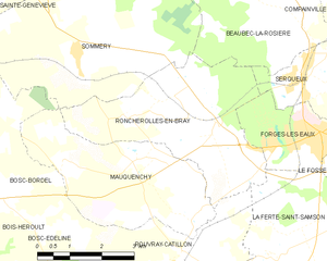
Roncherolles-en-Bray
- commune in Seine-Maritime, France
- Country:
- Postal Code: 76440
- Coordinates: 49° 36' 57" N, 1° 28' 2" E
- GPS tracks (wikiloc): [Link]
- Area: 14.37 sq km
- Population: 485


Serqueux
- commune in Seine-Maritime, France
- Country:
- Postal Code: 76440
- Coordinates: 49° 37' 54" N, 1° 32' 17" E
- GPS tracks (wikiloc): [Link]
- Area: 5.76 sq km
- Population: 1005
- Web site: [Link]
Le Fossé
- former commune in Seine-Maritime, France
- Country:
- Postal Code: 76440
- Coordinates: 49° 36' 31" N, 1° 34' 20" E
- GPS tracks (wikiloc): [Link]
- Area: 10.11 sq km
- Population: 498


La Ferté-Saint-Samson
- commune in Seine-Maritime, France
- Country:
- Postal Code: 76440
- Coordinates: 49° 34' 41" N, 1° 31' 29" E
- GPS tracks (wikiloc): [Link]
- Area: 19.05 sq km
- Population: 474