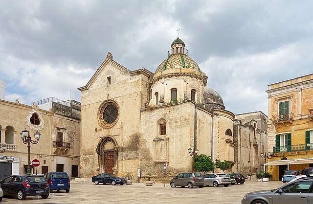
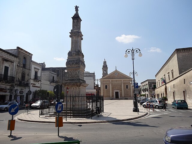
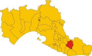
Fragagnano (Fragagnano)
.svg)
- Italian comune
 Hiking in Fragagnano
Fragagnano is a charming village located in the Apulia region of Italy, surrounded by the picturesque countryside. While it may not be as well-known for hiking as some other Italian regions, it offers opportunities for nature lovers and hikers to explore its beautiful landscapes and enjoy the local culture.
Hiking Highlights in Fragagnano:
-
Scenic Routes: The area around Fragagnano features lovely rural paths and trails that allow you to take in the stunning views of the Apulian countryside, olive groves, and vineyards. The rolling hills and traditional stone walls create a unique hiking experience.
-
Historical Sites: While hiking in and around Fragagnano, you may come across historical and cultural landmarks. Keep an eye out for ancient churches and traditional architecture that reflect the region's rich history.
-
Nearby Natural Parks: Consider extending your hiking experience to nearby natural parks, such as the Gargano National Park or the Alta Murgia National Park. These parks provide a more extensive network of trails and diverse habitats, from coastal cliffs to karst landscapes.
-
Local Flora and Fauna: The region is home to a variety of plants and wildlife. Be sure to bring your camera, as you might encounter native species and beautiful wildflowers, especially during the springtime.
-
Culinary Experiences: After a day of hiking, enjoy the local cuisine. Fragagnano and the surrounding areas are known for their excellent food and wine, making it a perfect way to unwind after your outdoor adventures.
Preparation Tips:
- Gear Up: Wear appropriate hiking shoes and clothing based on the season. It’s advisable to bring a backpack with water, snacks, and a basic first-aid kit.
- Stay Hydrated: Always carry enough water, especially during the warmer months, as you’ll be hiking in a Mediterranean climate.
- Local Guides: If you’re unfamiliar with the area, consider hiring a local guide who can provide insight into the best hiking spots and help you navigate the trails.
- Respect Nature: Follow Leave No Trace principles to preserve the natural beauty of the area.
Conclusion
Hiking in Fragagnano can be a delightful experience filled with scenic views, local culture, and tasty food. Whether you're a beginner or an experienced hiker, you can enjoy exploring this lesser-known gem in the Italian countryside.
- Country:

- Postal Code: 74022
- Local Dialing Code: 099
- Licence Plate Code: TA
- Coordinates: 40° 26' 0" N, 17° 28' 0" E


- GPS tracks (wikiloc): [Link]
- AboveSeaLevel: 126 м m
- Area: 22.41 sq km
- Population: 5232
- Web site: http://www.comune.fragagnano.ta.it/
- Wikipedia en: wiki(en)
- Wikipedia: wiki(it)
- Wikidata storage: Wikidata: Q52012
- Wikipedia Commons Category: [Link]
- Freebase ID: [/m/0fz7lc]
- GeoNames ID: Alt: [6538951]
- VIAF ID: Alt: [137645750]
- OSM relation ID: [40510]
- MusicBrainz area ID: [b54ae333-e484-4c8e-ad7b-177d533961b2]
- WOEID: [715763]
- TGN ID: [1044690]
- UN/LOCODE: [ITFR9]
- ISTAT ID: 073006
- Italian cadastre code: D754
Shares border with regions:


Taranto
- Italian comune
Hiking in Taranto
Hiking in Taranto, located in the Apulia region of Italy, offers a unique blend of natural beauty, historical sites, and coastal views. While Taranto itself is more known for its urban landscape and maritime history, there are several scenic areas nearby that are great for hiking enthusiasts....
- Country:
- Postal Code: 74121-74122-74123
- Local Dialing Code: 099
- Licence Plate Code: TA
- Coordinates: 40° 25' 5" N, 17° 14' 27" E
- GPS tracks (wikiloc): [Link]
- AboveSeaLevel: 15 м m
- Area: 249.86 sq km
- Population: 200385
- Web site: [Link]
Carosino
- Italian comune
Hiking in Carosino
Carosino is a small town in the Puglia region of Italy, known for its beautiful countryside and agricultural landscapes. While not a high-profile hiking destination, there are several opportunities for outdoor enthusiasts to explore the area. Here are some aspects to consider if you want to hike in and around Carosino:...
- Country:
- Postal Code: 74021
- Local Dialing Code: 099
- Licence Plate Code: TA
- Coordinates: 40° 28' 0" N, 17° 24' 0" E
- GPS tracks (wikiloc): [Link]
- AboveSeaLevel: 74 м m
- Area: 10.93 sq km
- Population: 7028
- Web site: [Link]

Grottaglie
- Italian comune
Hiking in Grottaglie
Grottaglie, a town in the Apulia region of Italy, is known for its rich history, beautiful ceramics, and charming landscapes. While it might not be a renowned hiking destination like some of Italy's mountainous regions, it does offer some opportunities for outdoor enthusiasts to enjoy nature and explore the local countryside. Here are a few aspects to consider when hiking in and around Grottaglie:...
- Country:
- Postal Code: 74023
- Local Dialing Code: 099
- Licence Plate Code: TA
- Coordinates: 40° 32' 13" N, 17° 26' 14" E
- GPS tracks (wikiloc): [Link]
- AboveSeaLevel: 133 м m
- Area: 102.12 sq km
- Population: 31890
- Web site: [Link]


Lizzano
- Italian comune
Hiking in Lizzano
Lizzano, located in the Apulia region of Italy, offers a unique blend of stunning landscapes, rich history, and a chance to experience the local culture through hiking. Here are some key points about hiking in Lizzano and its surroundings:...
- Country:
- Postal Code: 74020
- Local Dialing Code: 099
- Licence Plate Code: TA
- Coordinates: 40° 23' 31" N, 17° 26' 54" E
- GPS tracks (wikiloc): [Link]
- AboveSeaLevel: 0 м m
- Area: 47.18 sq km
- Population: 9990
- Web site: [Link]


Monteparano
- Italian comune
Hiking in Monteparano
Monteparano, located in the province of Taranto in the Apulia region of Italy, offers a unique hiking experience characterized by its beautiful landscapes, historical sites, and cultural charm. Here’s what you can expect when hiking in Monteparano:...
- Country:
- Postal Code: 74020
- Local Dialing Code: 099
- Licence Plate Code: TA
- Coordinates: 40° 27' 0" N, 17° 25' 0" E
- GPS tracks (wikiloc): [Link]
- AboveSeaLevel: 135 м m
- Area: 3.85 sq km
- Population: 2379
- Web site: [Link]


San Marzano di San Giuseppe
- Italian comune
Hiking in San Marzano di San Giuseppe
San Marzano di San Giuseppe is a small town located in the Apulia region of Italy, specifically in the province of Taranto. While it may not be a well-known hiking destination, there are opportunities for outdoor activities and exploring the beautiful Apulian countryside in and around this area....
- Country:
- Postal Code: 74020
- Local Dialing Code: 099
- Licence Plate Code: TA
- Coordinates: 40° 27' 0" N, 17° 30' 0" E
- GPS tracks (wikiloc): [Link]
- AboveSeaLevel: 134 м m
- Area: 19.19 sq km
- Population: 9228
- Web site: [Link]
Sava
- Italian comune
Hiking in Sava
Sava, located in the Apulia region of Italy, is a charming little town known for its picturesque landscapes and unique cultural heritage. While it is not a widely-known hiking destination compared to some of Italy's larger national parks, it offers some beautiful trails and natural areas that can be explored. Here are some things to consider when hiking in and around Sava:...
- Country:
- Postal Code: 74028
- Local Dialing Code: 099
- Licence Plate Code: TA
- Coordinates: 40° 24' 1" N, 17° 34' 0" E
- GPS tracks (wikiloc): [Link]
- AboveSeaLevel: 108 м m
- Area: 44.57 sq km
- Population: 16076
- Web site: [Link]