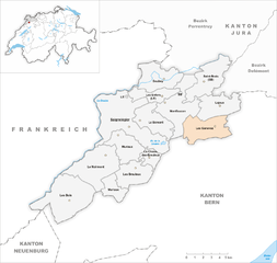
Franches-Montagnes District (Franches-Montagnes)

- district in Switzerland
 Hiking in Franches-Montagnes District
The Franches-Montagnes District, located in the Jura Mountains of Switzerland, is a hidden gem for hiking enthusiasts. This beautiful region offers a variety of trails that showcase stunning natural landscapes, charming villages, and rich cultural heritage. Here are some highlights about hiking in the area:
Scenic Trails
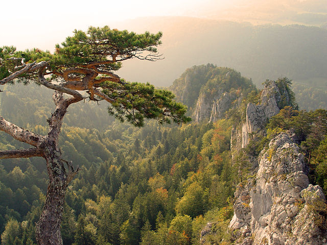
- Diverse Terrain: The district features a mix of gentle rolling hills, dense forests, and open pastures, with panoramic views over the surrounding mountains.
- Marked Trails: Numerous well-marked hiking trails are available, catering to different skill levels, from easy walks to more challenging hikes.
- Circular Routes: Many trails offer circular routes that allow hikers to explore multiple points of interest without needing to retrace steps.
Noteworthy Hikes
- Les Breuleux to Saignelégier: A popular trail that provides beautiful views of the landscape and passes through picturesque towns.
- Creux du Van: A bit further afield, this dramatic natural amphitheater is worth the hike for its breathtaking views.
- The Jura Crest Trail: A longer trek that connects various points along the Jura range, providing a unique perspective of the region.
Nature and Wildlife
- Rich Biodiversity: The Franches-Montagnes District is home to numerous flora and fauna, including wildflowers, deer, and various bird species.
- Nature Reserves: Several areas are designated as nature reserves, emphasizing conservation and providing opportunities for wildlife watching.
Cultural Highlights
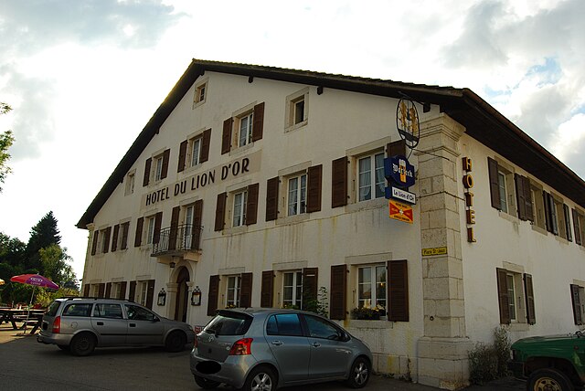
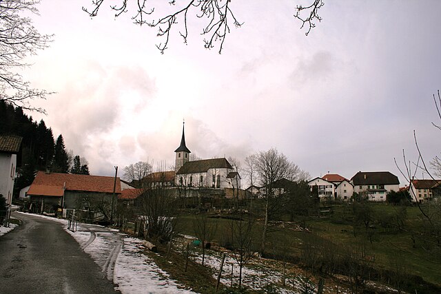
- Local Villages: Towns like Saignelégier, Les Breuleux, and La Chaux-de-Fonds offer insight into local culture, architecture, and history.
- Traditional Farms: The region is known for its traditional farming practices, and you may encounter local cheese producers and artisan shops.
Hiking Tips
- Weather Preparedness: Always check the weather conditions before heading out, as they can change rapidly in mountainous regions.
- Proper Gear: Wear suitable hiking boots, dress in layers, and bring necessary supplies such as water, snacks, and maps.
- Altitude Awareness: Be mindful of altitude if you choose to hike at higher elevations, and acclimatize as necessary.
Accessibility
- The Franches-Montagnes District is easily accessible by public transport from major Swiss cities, making it a convenient destination for day hikers and multi-day treks alike.
Whether you're seeking a peaceful stroll in nature or a more adventurous trek, the Franches-Montagnes District offers a rewarding hiking experience filled with natural beauty and cultural richness.
- Country:

- Capital: Saignelégier
- Licence Plate Code: JU
- Coordinates: 47° 15' 0" N, 6° 59' 0" E


- GPS tracks (wikiloc): [Link]
- AboveSeaLevel: 1036 м m
- Area: 200.18 sq km
- Wikipedia en: wiki(en)
- Wikipedia: wiki(de)
- Wikidata storage: Wikidata: Q167627
- Wikipedia Commons Category: [Link]
- Freebase ID: [/m/026hjlw]
- GeoNames ID: Alt: [6458790]
Includes regions:


Soubey
- municipality in Switzerland
Hiking in Soubey
Soubey is a picturesque village located in the Jura Mountains of Switzerland, known for its beautiful landscapes and extensive hiking trails. The area offers a variety of hiking opportunities suitable for all levels of hikers. Here are some key points about hiking in Soubey:...
- Country:
- Postal Code: 2887
- Licence Plate Code: JU
- Coordinates: 47° 18' 37" N, 7° 2' 26" E
- GPS tracks (wikiloc): [Link]
- AboveSeaLevel: 566 м m
- Area: 13.51 sq km
- Population: 132
- Web site: [Link]


Saignelégier
- municipality in Switzerland
Hiking in Saignelégier
Saignelégier, located in the picturesque Jura Mountains of Switzerland, is an excellent destination for hiking enthusiasts. This charming town is surrounded by beautiful landscapes, making it a popular spot for both casual walkers and serious hikers....
- Country:
- Postal Code: 2350
- Local Dialing Code: 032
- Licence Plate Code: JU
- Coordinates: 47° 15' 0" N, 7° 0' 0" E
- GPS tracks (wikiloc): [Link]
- AboveSeaLevel: 978 м m
- Area: 31.64 sq km
- Population: 2558
- Web site: [Link]


Lajoux
- municipality in the canton of Jura, Switzerland
Hiking in Lajoux
Lajoux is a charming village located in the Jura Mountains of Switzerland, known for its lush landscapes and extensive hiking opportunities. Here’s an overview of what you can expect when hiking in and around Lajoux:...
- Country:
- Postal Code: 2718
- Local Dialing Code: 032
- Licence Plate Code: JU
- Coordinates: 47° 16' 50" N, 7° 8' 15" E
- GPS tracks (wikiloc): [Link]
- AboveSeaLevel: 960 м m
- Area: 12.35 sq km
- Population: 664
- Web site: [Link]

Montfaucon
- municipality in the canton of Jura, Switzerland
Hiking in Montfaucon
Montfaucon is a charming village in the Jura region of Switzerland and offers a variety of hiking opportunities amidst beautiful natural landscapes. The Jura mountains are known for their rolling hills, dense forests, and panoramic views, making it an excellent destination for hikers of all levels....
- Country:
- Postal Code: 2875
- Local Dialing Code: 032
- Licence Plate Code: JU
- Coordinates: 47° 17' 0" N, 7° 3' 0" E
- GPS tracks (wikiloc): [Link]
- AboveSeaLevel: 996 м m
- Area: 14.82 sq km
- Population: 623
- Web site: [Link]


Les Breuleux
- municipality in Switzerland
Hiking in Les Breuleux
Les Breuleux is a picturesque village located in the Jura region of Switzerland, known for its stunning natural landscapes and rich biodiversity. Hiking in this area offers a fantastic opportunity to experience the serene beauty of the Swiss countryside....
- Country:
- Postal Code: 2345
- Local Dialing Code: 032
- Licence Plate Code: JU
- Coordinates: 47° 12' 19" N, 7° 0' 9" E
- GPS tracks (wikiloc): [Link]
- AboveSeaLevel: 1039 м m
- Area: 10.80 sq km
- Population: 1536
- Web site: [Link]


Le Bémont
- municipality in Switzerland
Hiking in Le Bémont
Le Bémont is a picturesque village located in the Jura region of Switzerland, known for its stunning landscapes, rolling hills, and lush forests. It's an excellent destination for hiking enthusiasts seeking both tranquility and breathtaking views. Here are some key points to consider when planning a hiking trip to Le Bémont:...
- Country:
- Postal Code: 2877
- Local Dialing Code: 032
- Licence Plate Code: JU
- Coordinates: 47° 16' 0" N, 7° 1' 0" E
- GPS tracks (wikiloc): [Link]
- AboveSeaLevel: 982 м m
- Area: 11.64 sq km
- Population: 314

Muriaux
- municipality in Switzerland
Hiking in Muriaux
Muriaux is a picturesque area located in the Jura Mountains of Switzerland. It offers numerous hiking opportunities characterized by beautiful landscapes, dense forests, and panoramic views. Here are some highlights and tips for hiking in Muriaux:...
- Country:
- Postal Code: 2338
- Local Dialing Code: 032
- Licence Plate Code: JU
- Coordinates: 47° 15' 0" N, 6° 59' 0" E
- GPS tracks (wikiloc): [Link]
- AboveSeaLevel: 947 м m
- Area: 14.33 sq km
- Population: 493
- Web site: [Link]

Saint-Brais
- municipality in Switzerland
Hiking in Saint-Brais
Saint-Brais is a charming commune in the Jura Mountains of Switzerland, known for its stunning natural scenery, well-marked hiking trails, and rich biodiversity. Here are some key points about hiking in the area:...
- Country:
- Postal Code: 2874
- Local Dialing Code: 032
- Licence Plate Code: JU
- Coordinates: 47° 18' 0" N, 7° 7' 0" E
- GPS tracks (wikiloc): [Link]
- AboveSeaLevel: 945 м m
- Area: 15.19 sq km
- Population: 226


Le Noirmont
- municipality in Switzerland
Hiking in Le Noirmont
Le Noirmont is a picturesque region located in the Jura Mountains of Switzerland. It offers a variety of hiking opportunities for outdoor enthusiasts, with stunning views, dense forests, and charming alpine landscapes. Here are some key points to consider when planning a hike in Le Noirmont:...
- Country:
- Postal Code: 2340
- Local Dialing Code: 032
- Licence Plate Code: JU
- Coordinates: 47° 12' 49" N, 6° 56' 39" E
- GPS tracks (wikiloc): [Link]
- AboveSeaLevel: 994 м m
- Area: 20.40 sq km
- Population: 1856
- Web site: [Link]

Les Genevez
- municipality in Switzerland
Hiking in Les Genevez
Les Genevez is a charming village located in the Jura region of Switzerland, known for its beautiful landscapes, rolling hills, and dense forests, making it an ideal destination for hiking enthusiasts. Here are some highlights and tips for hiking in Les Genevez:...
- Country:
- Postal Code: 2714
- Local Dialing Code: 032
- Licence Plate Code: JU
- Coordinates: 47° 15' 15" N, 7° 6' 50" E
- GPS tracks (wikiloc): [Link]
- AboveSeaLevel: 1027 м m
- Area: 13.64 sq km
- Population: 499
- Web site: [Link]


Les Bois
- municipality in Switzerland
Hiking in Les Bois
Les Bois, located in the beautiful region of Switzerland, is a fantastic place for hiking enthusiasts. While it's a smaller village, it is situated near several hiking trails that lead through stunning landscapes of the Swiss Alps, encompassing lush forests, rolling hills, and panoramic views of surrounding peaks....
- Country:
- Postal Code: 2336
- Local Dialing Code: 032
- Licence Plate Code: JU
- Coordinates: 47° 10' 46" N, 6° 53' 54" E
- GPS tracks (wikiloc): [Link]
- AboveSeaLevel: 1025 м m
- Area: 24.7 sq km
- Population: 1248
- Web site: [Link]


La Chaux-des-Breuleux
- municipality in Switzerland
Hiking in La Chaux-des-Breuleux
La Chaux-des-Breuleux, located in the Jura Mountains of Switzerland, offers a variety of hiking opportunities with stunning landscapes, rich wildlife, and scenic trails. Here are some key points to consider when hiking in this area:...
- Country:
- Postal Code: 2345
- Local Dialing Code: 032
- Licence Plate Code: JU
- Coordinates: 47° 13' 21" N, 7° 1' 39" E
- GPS tracks (wikiloc): [Link]
- AboveSeaLevel: 1016 м m
- Area: 4.12 sq km
- Population: 89


Les Enfers
- municipality in Switzerland
Hiking in Les Enfers
Les Enfers, which translates to "The Hells," is a stunning hiking area located in the French Alps, specifically within the Parc National de la Vanoise. It's known for its dramatic landscapes, featuring steep cliffs, deep gorges, and breathtaking views of the surrounding mountains....
- Country:
- Postal Code: 2875
- Local Dialing Code: 032
- Licence Plate Code: JU
- Coordinates: 47° 17' 19" N, 7° 2' 50" E
- GPS tracks (wikiloc): [Link]
- AboveSeaLevel: 955 м m
- Area: 7.09 sq km
- Population: 138