Fresse-sur-Moselle (Fresse-sur-Moselle)

- commune in Vosges, France
- Country:

- Postal Code: 88160
- Coordinates: 47° 52' 33" N, 6° 47' 14" E


- GPS tracks (wikiloc): [Link]
- Area: 18.41 sq km
- Population: 1757
- Wikipedia en: wiki(en)
- Wikipedia: wiki(fr)
- Wikidata storage: Wikidata: Q920853
- Wikipedia Commons Category: [Link]
- Freebase ID: [/m/03qh72c]
- Freebase ID: [/m/03qh72c]
- GeoNames ID: Alt: [3017124]
- GeoNames ID: Alt: [3017124]
- SIREN number: [218801884]
- SIREN number: [218801884]
- BnF ID: [15279116g]
- BnF ID: [15279116g]
- PACTOLS thesaurus ID: [pcrtjuBXkjR2Ds]
- PACTOLS thesaurus ID: [pcrtjuBXkjR2Ds]
- INSEE municipality code: 88188
- INSEE municipality code: 88188
Shares border with regions:


Le Thillot
- commune in Vosges, France
- Country:
- Postal Code: 88160
- Coordinates: 47° 52' 48" N, 6° 45' 54" E
- GPS tracks (wikiloc): [Link]
- AboveSeaLevel: 709 м m
- Area: 15.14 sq km
- Population: 3513
- Web site: [Link]

Bussang
- commune in Vosges, France
- Country:
- Postal Code: 88540
- Coordinates: 47° 53' 8" N, 6° 51' 13" E
- GPS tracks (wikiloc): [Link]
- Area: 27.63 sq km
- Population: 1432
- Web site: [Link]

Haut-du-Them-Château-Lambert
- commune in Haute-Saône, France
- Country:
- Postal Code: 70440
- Coordinates: 47° 50' 34" N, 6° 43' 21" E
- GPS tracks (wikiloc): [Link]
- AboveSeaLevel: 500 м m
- Area: 25.16 sq km
- Population: 438
- Web site: [Link]

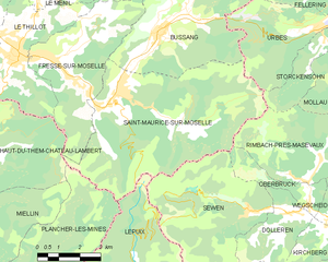
Saint-Maurice-sur-Moselle
- commune in Vosges, France
- Country:
- Postal Code: 88560
- Coordinates: 47° 51' 28" N, 6° 49' 26" E
- GPS tracks (wikiloc): [Link]
- Area: 37 sq km
- Population: 1390


Le Ménil
- commune in Vosges, France
- Country:
- Postal Code: 88160
- Coordinates: 47° 54' 26" N, 6° 46' 58" E
- GPS tracks (wikiloc): [Link]
- Area: 20.38 sq km
- Population: 1077
- Web site: [Link]