Furmeyer (Furmeyer)
- commune in Hautes-Alpes, France
 Hiking in Furmeyer
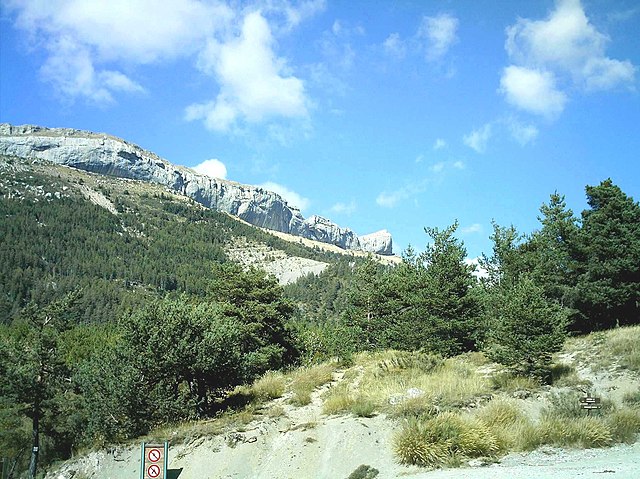
Furmeyer is a fantastic location for hiking enthusiasts, offering a range of trails suited for different skill levels amidst stunning natural scenery. Nestled within a mountainous region, hikers can enjoy diverse landscapes, from lush forests to rocky outcrops, and often breathtaking views.
Key Features of Hiking in Furmeyer:
-
Trail Diversity:
- Furmeyer has trails that cater to various difficulty levels. Beginners can enjoy easier paths that are well-marked, while more experienced hikers can challenge themselves on steep and rugged terrain.
-
Natural Beauty:
- Hikers will encounter beautiful flora and fauna, potentially spotting wildlife, and enjoying picturesque vistas. The changing seasons also provide a different experience throughout the year, with vibrant colors in the autumn and blooming wildflowers in the spring.
-
Scenic Views:
- Many trails lead to elevated viewpoints that offer panoramic views of the surrounding mountains and valleys. Don’t forget your camera!
-
Access:
- Depending on your starting point, access to Furmeyer may vary. Be sure to check local maps and guides for information on parking and trailheads.
-
Safety and Preparedness:
- Always plan your hike according to your skill level and experience. Carry enough water, snacks, and appropriate gear. It’s also wise to check weather conditions before heading out.
-
Guided Hikes:
- If you’re unfamiliar with the area or wish to enhance your experience, consider joining a guided hike. Local guides can provide insights into the natural environment and ensure your safety.
-
Wildlife and Conservation:
- Respect the local wildlife and natural habitats. Follow Leave No Trace principles to help maintain the beauty of Furmeyer for future hikers.
Conclusion:
Overall, hiking in Furmeyer offers a rich outdoor experience for those looking to explore nature, enjoy physical activity, and connect with the stunning landscapes. Always remember to prepare adequately and enjoy your adventure!
- Country:

- Postal Code: 05400
- Coordinates: 44° 32' 11" N, 5° 51' 13" E


- GPS tracks (wikiloc): [Link]
- Area: 14.27 sq km
- Population: 143
- Wikipedia en: wiki(en)
- Wikipedia: wiki(fr)
- Wikidata storage: Wikidata: Q1087770
- Wikipedia Commons Category: [Link]
- Freebase ID: [/m/03mfkx7]
- Freebase ID: [/m/03mfkx7]
- GeoNames ID: Alt: [6446643]
- GeoNames ID: Alt: [6446643]
- SIREN number: [210500609]
- SIREN number: [210500609]
- INSEE municipality code: 05060
- INSEE municipality code: 05060
Shares border with regions:
Châteauneuf-d'Oze
- commune in Hautes-Alpes, France
Hiking in Châteauneuf-d'Oze
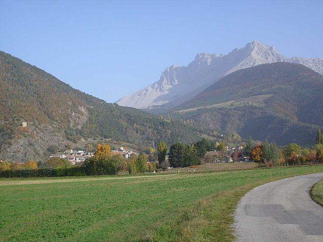
Châteauneuf-d'Oze is a charming village located in the Hautes-Alpes region of southeastern France. Nestled in the picturesque Oisans area, it's surrounded by stunning mountain scenery, making it an attractive destination for hikers. Here are some highlights and tips for hiking in and around Châteauneuf-d'Oze:...
- Country:
- Postal Code: 05400
- Coordinates: 44° 30' 42" N, 5° 51' 53" E
- GPS tracks (wikiloc): [Link]
- Area: 26.23 sq km
- Population: 27

Veynes
- commune in Hautes-Alpes, France
Hiking in Veynes
Veynes, located in the Hautes-Alpes region of France, offers a beautiful setting for hiking enthusiasts. The area is characterized by stunning mountain scenery, varied terrain, and a network of trails suitable for different skill levels. Here are some highlights and tips for hiking in Veynes:...
- Country:
- Postal Code: 05400
- Coordinates: 44° 32' 3" N, 5° 49' 25" E
- GPS tracks (wikiloc): [Link]
- Area: 42.6 sq km
- Population: 3159
- Web site: [Link]
Montmaur
- commune in Hautes-Alpes, France
Hiking in Montmaur
Montmaur, located in the Hautes-Alpes department of France, offers a range of hiking opportunities for outdoor enthusiasts. Nestled in the picturesque French Alps, this area is characterized by stunning landscapes, diverse flora and fauna, and a variety of trails suitable for different skill levels....
- Country:
- Postal Code: 05400
- Coordinates: 44° 34' 16" N, 5° 52' 27" E
- GPS tracks (wikiloc): [Link]
- Area: 48.77 sq km
- Population: 515