Furth an der Triesting (Furth an der Triesting)
- municipality in Austria
 Hiking in Furth an der Triesting
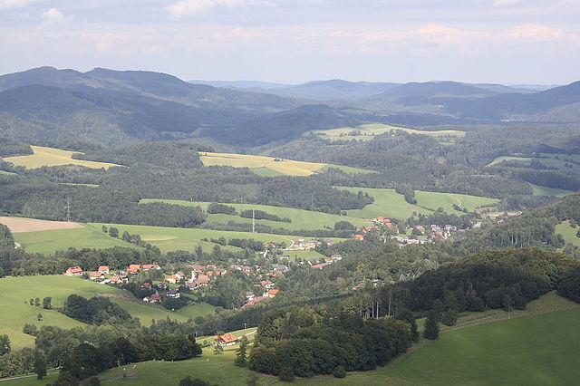
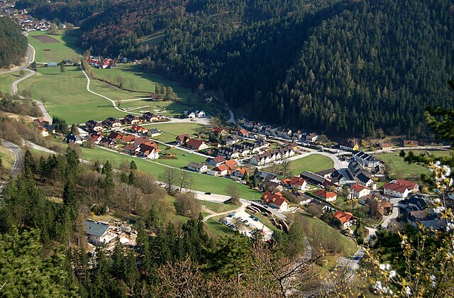
Furth an der Triesting is a picturesque village located in Lower Austria, surrounded by beautiful landscapes and outdoor activities, making it an excellent destination for hiking enthusiasts. The area is characterized by rolling hills, lush forests, and the serene Triesting River, which adds to the scenic beauty of the region.
Hiking Opportunities
-
Trails and Routes:
- There are various marked hiking trails around Furth an der Triesting, suitable for different skill levels—ranging from easy walks for families to more challenging routes for experienced hikers.
- The "Triestingtalweg" is a popular long-distance trail that follows the Triesting River and offers stunning views and nature experiences along the way.
-
Nature and Scenery:
- Hikers can enjoy diverse landscapes, including meadows, forests, and small vineyards. The area is also home to various wildlife, making it a good spot for nature lovers.
- Look out for viewpoints that provide excellent vistas of the surrounding hills and valleys.
-
Seasonal Hiking:
- Spring and autumn are particularly beautiful for hiking, with blooming flowers and colorful foliage offering fantastic photo opportunities.
- Winter hiking in the nearby areas can also be an option, with snow-covered trails and the possibility of winter sports in the region.
-
Infrastructure:
- The village is equipped with facilities like parking areas, local restaurants, and accommodations, making it a convenient base for hiking excursions.
- Local guides and maps are usually available, ensuring you can navigate the trails safely and efficiently.
Tips for Hiking in Furth an der Triesting
-
Preparation: Always check the weather forecast before heading out and dress accordingly. Wear sturdy hiking boots and bring necessary supplies, such as water, snacks, and a first aid kit.
-
Navigation: While many trails are well-marked, carrying a map or GPS device is advisable, especially for longer hikes or less familiar routes.
-
Respect Nature: Follow Leave No Trace principles, such as staying on marked paths, carrying out what you bring in, and respecting wildlife.
-
Local Customs: Familiarize yourself with any local regulations or customs, especially if you plan to hike through protected areas or private land.
Visiting Furth an der Triesting for hiking can be a refreshing and enjoyable experience, allowing you to connect with nature and explore the charm of Lower Austria.
- Country:

- Postal Code: 2564
- Local Dialing Code: 0 26 74
- Licence Plate Code: BN
- Coordinates: 47° 58' 22" N, 15° 58' 24" E


- GPS tracks (wikiloc): [Link]
- AboveSeaLevel: 422 м m
- Area: 64.20 sq km
- Population: 862
- Web site: http://www.furth-triesting.at
- Wikipedia en: wiki(en)
- Wikipedia: wiki(de)
- Wikidata storage: Wikidata: Q678562
- Wikipedia Commons Category: [Link]
- Freebase ID: [/m/02qss5n]
- GeoNames ID: Alt: [2779094]
- VIAF ID: Alt: [145402733]
- Library of Congress authority ID: Alt: [n79064164]
- Austrian municipality key: [30609]
Shares border with regions:

Altenmarkt an der Triesting
- municipality in Austria
 Hiking in Altenmarkt an der Triesting
Altenmarkt an der Triesting is a scenic area located in Austria, surrounded by the beautiful landscapes of Lower Austria. Hiking in this region offers a variety of trails suitable for different skill levels, allowing hikers to experience the natural beauty, cultural sites, and peaceful rural life....
- Country:

- Local Dialing Code: 02673
- Licence Plate Code: BN
- Coordinates: 48° 1' 0" N, 15° 59' 38" E


- GPS tracks (wikiloc): [Link]
- AboveSeaLevel: 390 м m
- Area: 63.43 sq km
- Population: 2113
- Web site: [Link]
Weissenbach an der Triesting
- municipality in Austria
 Hiking in Weissenbach an der Triesting
Weissenbach an der Triesting is a picturesque village in Lower Austria, situated along the Triesting River, surrounded by beautiful landscapes that make it an attractive destination for hiking enthusiasts. The region offers a variety of trails, each catering to different skill levels, allowing hikers to immerse themselves in nature while enjoying the scenic beauty of the area....
- Country:

- Local Dialing Code: 02674
- Licence Plate Code: BN
- Coordinates: 47° 58' 54" N, 16° 2' 17" E


- GPS tracks (wikiloc): [Link]
- AboveSeaLevel: 362 м m
- Area: 15.93 sq km
- Population: 1727
- Web site: [Link]

Kaumberg
- municipality in Austria
Kaumberg, located in the beautiful region of Lower Austria, offers a variety of hiking opportunities for enthusiasts of all levels. The area is rich in scenic landscapes, featuring lush forests, rolling hills, and breathtaking views of the surrounding countryside....
- Country:

- Postal Code: 2572
- Local Dialing Code: 02765
- Licence Plate Code: LF
- Coordinates: 48° 1' 25" N, 15° 53' 42" E


- GPS tracks (wikiloc): [Link]
- AboveSeaLevel: 494 м m
- Area: 43 sq km
- Population: 1016
- Web site: [Link]

Ramsau
- town in Lower Austria, Austria
Ramsau, located in Lower Austria, is a picturesque village surrounded by stunning natural landscapes, making it a fantastic destination for hiking enthusiasts. The region offers a variety of trails suited for different skill levels, from easy walks to challenging mountain hikes. Here are some highlights and tips for hiking in Ramsau:...
- Country:

- Postal Code: 3172
- Local Dialing Code: 02764
- Licence Plate Code: LF
- Coordinates: 48° 0' 0" N, 15° 48' 0" E


- GPS tracks (wikiloc): [Link]
- AboveSeaLevel: 470 м m
- Area: 54.69 sq km
- Population: 850
- Web site: [Link]


Muggendorf
- municipality in Austria
Muggendorf, located in the scenic region of Lower Austria, is known for its beautiful landscapes and rich natural diversity, making it a fantastic destination for hikers. Situated near the Vienna Woods, the area offers a variety of trails suitable for different skill levels. Here are some highlights of hiking in Muggendorf:...
- Country:

- Postal Code: 2763
- Local Dialing Code: 02632
- Licence Plate Code: WB
- Coordinates: 47° 54' 0" N, 15° 56' 0" E


- GPS tracks (wikiloc): [Link]
- AboveSeaLevel: 450 м m
- Area: 50.93 sq km
- Population: 528
- Web site: [Link]


Pottenstein
- municipality in Austria
Pottenstein, located in the picturesque Upper Austria region, is a fantastic destination for hiking enthusiasts. This charming village is nestled in a scenic valley surrounded by lush forests, rolling hills, and stunning limestone formations, making it an ideal spot for outdoor adventures....
- Country:

- Local Dialing Code: 02672
- Licence Plate Code: BN
- Coordinates: 47° 57' 0" N, 16° 5' 0" E


- GPS tracks (wikiloc): [Link]
- AboveSeaLevel: 324 м m
- Area: 33.4 sq km
- Population: 2909
- Web site: [Link]