Fuscaldo (Fuscaldo)
.svg)
- Italian comune
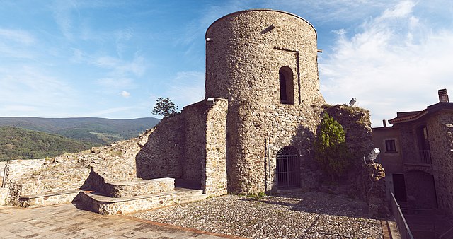
 Hiking in Fuscaldo
Fuscaldo is a picturesque town located in the Calabria region of southern Italy, situated near the Tyrrhenian Sea. It offers a range of hiking opportunities, characterized by beautiful landscapes, mountains, and coastal views.
Hiking Trails
-
Sila National Park: Nearby Fuscaldo, you can explore trails within the Sila National Park, known for its lush forests, mountains, and diverse wildlife. Trails vary in difficulty, with options for both beginners and more experienced hikers.
-
Mount Cocuzzo: This prominent peak offers several hiking routes with breathtaking vistas. The trails can be challenging but provide rewarding views of the surrounding countryside and the coast.
-
Coastal Trails: The coastline around Fuscaldo offers delightful walking paths with views of the sea. These trails can be more leisurely and are great for enjoying the scenery while being close to the water.
Hiking Tips
-
Best Time to Hike: The ideal months for hiking in Fuscaldo are late spring (May to June) and early autumn (September to October) when the weather is mild, and the landscapes are particularly beautiful.
-
Gear: Bring appropriate hiking gear including sturdy boots, water, sunscreen, and snacks. Some trails may require trekking poles, especially in rocky areas.
-
Navigating Trails: It’s advisable to have a good map or a GPS device, as some trails might not be well-marked. Local hiking apps can also be beneficial.
-
Local Guides: Consider hiring a local guide who can provide insights on the best trails and ensure a safe hiking experience.
Attractions Post-Hike
After a long day of hiking, you can enjoy the local cuisine, which features fresh seafood and traditional Calabrian dishes. Visiting historical sites in and around Fuscaldo can also enhance your experience.
Enjoy your hiking adventure in Fuscaldo, where natural beauty and cultural heritage await!
- Country:

- Postal Code: 87024
- Local Dialing Code: 0982
- Licence Plate Code: CS
- Coordinates: 39° 25' 0" N, 16° 2' 0" E


- GPS tracks (wikiloc): [Link]
- AboveSeaLevel: 350 м m
- Area: 60.8 sq km
- Population: 8108
- Web site: http://www.comune.fuscaldo.cs.it/
- Wikipedia en: wiki(en)
- Wikipedia: wiki(it)
- Wikidata storage: Wikidata: Q53884
- Wikipedia Commons Category: [Link]
- Freebase ID: [/m/0f_q79]
- GeoNames ID: Alt: [6540037]
- VIAF ID: Alt: [247388589]
- OSM relation ID: [39921]
- GND ID: Alt: [4612042-7]
- Library of Congress authority ID: Alt: [nr97044982]
- TGN ID: [1044718]
- ISTAT ID: 078058
- Italian cadastre code: D828
Shares border with regions:


Cerzeto
- Italian comune
Hiking in Cerzeto
Cerzeto is a charming town located in the Calabria region of Southern Italy. While it's not as widely known as some other hiking destinations, it offers opportunities for those seeking less crowded trails amid beautiful landscapes....
- Country:
- Postal Code: 87040
- Local Dialing Code: 0984
- Licence Plate Code: CS
- Coordinates: 39° 31' 0" N, 16° 7' 0" E
- GPS tracks (wikiloc): [Link]
- AboveSeaLevel: 470 м m
- Area: 21.9 sq km
- Population: 1359
- Web site: [Link]

Guardia Piemontese
- Italian comune
Hiking in Guardia Piemontese
Guardia Piemontese, located in the Calabria region of southern Italy, is an enchanting area for hiking enthusiasts. Nestled in the Sila National Park, it offers stunning landscapes, rich biodiversity, and a glimpse into the local culture and history....
- Country:
- Postal Code: 87020
- Local Dialing Code: 0982
- Licence Plate Code: CS
- Coordinates: 39° 28' 0" N, 16° 0' 0" E
- GPS tracks (wikiloc): [Link]
- AboveSeaLevel: 515 м m
- Area: 21.46 sq km
- Population: 1913
- Web site: [Link]
Lattarico
- Italian comune
Hiking in Lattarico
Lattarico, a charming town located in the Calabria region of southern Italy, offers a variety of hiking opportunities that showcase its stunning natural beauty and rich cultural heritage. The surrounding landscape is characterized by rugged mountains, lush forests, and picturesque views of the Tyrrhenian Sea. Here are some highlights of hiking in and around Lattarico:...
- Country:
- Postal Code: 87010
- Local Dialing Code: 0984
- Licence Plate Code: CS
- Coordinates: 39° 28' 0" N, 16° 8' 0" E
- GPS tracks (wikiloc): [Link]
- AboveSeaLevel: 410 м m
- Area: 43.93 sq km
- Population: 3959
- Web site: [Link]
Mongrassano
- Italian comune
Hiking in Mongrassano
Mongrassano is a small town in Calabria, Italy, with a rich history and beautiful landscapes that are ideal for hiking enthusiasts. The area around Mongrassano offers a mix of natural beauty, including picturesque hills, lush forests, and scenic views of the surrounding regions. Here are some highlights for hiking in and around Mongrassano:...
- Country:
- Postal Code: 87040
- Local Dialing Code: 0984
- Licence Plate Code: CS
- Coordinates: 39° 32' 0" N, 16° 7' 0" E
- GPS tracks (wikiloc): [Link]
- AboveSeaLevel: 540 м m
- Area: 35.16 sq km
- Population: 1562
- Web site: [Link]


Montalto Uffugo
- Italian comune
Hiking in Montalto Uffugo
Montalto Uffugo, located in the Calabria region of southern Italy, offers a variety of hiking opportunities that showcase its beautiful landscapes, rich biodiversity, and historical sites. Here are some key highlights for hiking in this area:...
- Country:
- Postal Code: 87046
- Local Dialing Code: 0984
- Licence Plate Code: CS
- Coordinates: 39° 24' 0" N, 16° 9' 0" E
- GPS tracks (wikiloc): [Link]
- AboveSeaLevel: 500 м m
- Area: 76.67 sq km
- Population: 20213
- Web site: [Link]


Paola
- Italian comune
Hiking in Paola
Paola, located in the Calabria region of southern Italy, offers a variety of hiking opportunities that showcase its beautiful landscapes, historical sites, and coastal views. Here are some highlights for hiking in and around Paola:...
- Country:
- Postal Code: 87027
- Local Dialing Code: 0982
- Licence Plate Code: CS
- Coordinates: 39° 22' 0" N, 16° 2' 0" E
- GPS tracks (wikiloc): [Link]
- AboveSeaLevel: 94 м m
- Area: 42.88 sq km
- Population: 15716
- Web site: [Link]
Rota Greca
- Italian comune
Hiking in Rota Greca
Rota Greca is a beautiful area in Calabria, Italy, known for its stunning natural landscapes and rich biodiversity. It is particularly favored by those who enjoy outdoor activities such as hiking. Here are some key points to consider when hiking in Rota Greca:...
- Country:
- Postal Code: 87010
- Local Dialing Code: 0984
- Licence Plate Code: CS
- Coordinates: 39° 28' 0" N, 16° 7' 0" E
- GPS tracks (wikiloc): [Link]
- AboveSeaLevel: 510 м m
- Area: 13.12 sq km
- Population: 1106
- Web site: [Link]


San Benedetto Ullano
- Italian comune
Hiking in San Benedetto Ullano
San Benedetto Ullano is a small town located in the Calabria region of southern Italy, surrounded by picturesque landscapes and natural beauty that make it an appealing destination for hiking enthusiasts. The area is characterized by its mountainous terrain, lush forests, and stunning views of the surrounding countryside....
- Country:
- Postal Code: 87040
- Local Dialing Code: 0984
- Licence Plate Code: CS
- Coordinates: 39° 26' 0" N, 16° 7' 0" E
- GPS tracks (wikiloc): [Link]
- AboveSeaLevel: 460 м m
- Area: 19.57 sq km
- Population: 1511
- Web site: [Link]