
Göttingen (Göttingen)

- Large city in Lower Saxony, Germany
 Hiking in Göttingen
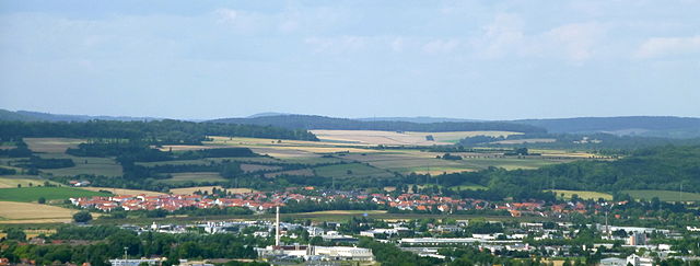
Göttingen, located in Lower Saxony, Germany, is surrounded by beautiful landscapes and offers a range of hiking opportunities suitable for all levels of experience. The region is characterized by its rolling hills, lush forests, and picturesque valleys, making it a great destination for nature lovers.
Popular Hiking Areas:
-
Bismarck Tower: A popular hiking destination, the Bismarck Tower offers a scenic view of Göttingen and its surroundings. There are trails leading through the forested hills to the tower, making for a pleasant hike.
-
The Göttingen Forest (Göttinger Wald): Just south of the city, the Göttingen Forest features numerous trails that weave through the woods. You'll find well-marked paths suitable for both casual walks and more vigorous hikes. This area is ideal for family outings and is rich in biodiversity.
-
Hainberg Nature Reserve: This protected area is a great spot for nature walks and bird watching. The trails here can be more challenging, offering a chance to explore the local flora and fauna in a peaceful setting.
-
Leinetal (Leine Valley): A little further from Göttingen, the Leine Valley offers a scenic landscape ideal for hiking. The trails along the river provide beautiful views and the chance to explore charming villages.
Hiking Tips:
- Trail Maps: Make sure to pick up a map or use a hiking app to familiarize yourself with the trails and ensure you're on the right path.
- Weather: Check the weather before heading out, as conditions can change quickly. Dressing in layers is advisable.
- Safety: Always let someone know your plans and expected return time. Carry a first aid kit, plenty of water, and snacks.
- Respect Nature: Follow the Leave No Trace principles—stay on marked trails, pack out what you pack in, and be respectful of wildlife.
Local Amenities:
Göttingen has various places to eat and rest, making it perfect for a day hiking trip. After a hike, you can enjoy the town's vibrant atmosphere, visit local cafes, or explore its rich cultural history.
Overall, hiking around Göttingen can be a rewarding experience, combining physical activity with the beauty of nature and the charm of the local area.
- Country:

- Postal Code: 37001–37099
- Local Dialing Code: 551
- Licence Plate Code: GÖ
- Coordinates: 51° 32' 2" N, 9° 56' 8" E


- GPS tracks (wikiloc): [Link]
- AboveSeaLevel: 150 м m
- Area: 116.93 sq km
- Population: 119177
- Web site: https://www.goettingen.de/
- Wikipedia en: wiki(en)
- Wikipedia: wiki(de)
- Wikidata storage: Wikidata: Q3033
- Wikipedia Commons Gallery: [Link]
- Wikipedia Commons Category: [Link]
- Wikipedia Commons Maps Category: [Link]
- Freebase ID: [/m/0bj40]
- Freebase ID: [/m/0bj40]
- GeoNames ID: Alt: [2918632]
- GeoNames ID: Alt: [2918632]
- BnF ID: [11954851z]
- BnF ID: [11954851z]
- VIAF ID: Alt: [233669754]
- VIAF ID: Alt: [233669754]
- OSM relation ID: [191361]
- OSM relation ID: [191361]
- GND ID: Alt: [4021477-1]
- GND ID: Alt: [4021477-1]
- archINFORM location ID: [350]
- archINFORM location ID: [350]
- Library of Congress authority ID: Alt: [n79065961]
- Library of Congress authority ID: Alt: [n79065961]
- MusicBrainz area ID: [e1118b38-3b6b-4e3b-a260-ba83a89eb09a]
- MusicBrainz area ID: [e1118b38-3b6b-4e3b-a260-ba83a89eb09a]
- Quora topic ID: [Göttingen-Germany]
- Quora topic ID: [Göttingen-Germany]
- Encyclopædia Britannica Online ID: [place/Gottingen]
- Encyclopædia Britannica Online ID: [place/Gottingen]
- Encyclopædia Universalis ID: [gottingen-gottingue]
- Encyclopædia Universalis ID: [gottingen-gottingue]
- HDS ID: [6589]
- HDS ID: [6589]
- EMLO location ID: [cc539adf-0832-4829-9699-653e191879d0]
- EMLO location ID: [cc539adf-0832-4829-9699-653e191879d0]
- Facebook Places ID: [108157735878329]
- Facebook Places ID: [108157735878329]
- Great Russian Encyclopedia Online ID: [2356921]
- Great Russian Encyclopedia Online ID: [2356921]
- Nomisma ID: [goettingen]
- Nomisma ID: [goettingen]
- Klexikon article ID: [Göttingen]
- Klexikon article ID: [Göttingen]
- NDL Auth ID: [00628482]
- NDL Auth ID: [00628482]
- German municipality key: 03159016
- German municipality key: 03159016
Includes regions:


Deppoldshausen
- human settlement in Germany
Hiking in Deppoldshausen
Deppoldshausen is a small village located in Germany, typically known for its picturesque surroundings and access to nature, ideal for hiking enthusiasts. While it might not be as famous as some major hiking destinations, there are several reasons to explore the hiking opportunities in and around this area....
- Country:
- Postal Code: 37077
- Local Dialing Code: 0551
- Coordinates: 51° 35' 4" N, 9° 57' 58" E
- GPS tracks (wikiloc): [Link]
- Area: 4.88 sq km

Elliehausen
- human settlement in Germany
Hiking in Elliehausen
Elliehausen is a small village located in the Göttingen district of Lower Saxony, Germany. While it may not be as well-known as larger hiking destinations, the surrounding area offers some beautiful landscapes and opportunities for outdoor activities, including hiking. Here are some things to consider if you're planning to hike in and around Elliehausen:...
- Country:
- Postal Code: 37079
- Local Dialing Code: 0551
- Coordinates: 51° 33' 6" N, 9° 52' 11" E
- GPS tracks (wikiloc): [Link]
- AboveSeaLevel: 176 м m
- Area: 6.33 sq km
Esebeck
- human settlement in Germany
Hiking in Esebeck
It seems there might be a slight misunderstanding, as there isn't a well-known hiking destination specifically called "Esebeck." However, if you meant a different location or are referring to a lesser-known trail, please provide more details or clarify the name....
- Country:
- Postal Code: 37079
- Local Dialing Code: 0551
- Coordinates: 51° 33' 50" N, 9° 50' 39" E
- GPS tracks (wikiloc): [Link]
- AboveSeaLevel: 255 м m
- Area: 5.83 sq km
Geismar (Göttingen)
- human settlement in Germany
Hiking in Geismar (Göttingen)
Geismar is a district located in Göttingen, Germany, surrounded by beautiful landscapes that offer a variety of hiking opportunities. Here are some highlights and tips for hiking in and around Geismar:...
- Country:
- Postal Code: 37083
- Local Dialing Code: 0551
- Coordinates: 51° 31' 0" N, 9° 57' 13" E
- GPS tracks (wikiloc): [Link]
- Area: 14.23 sq km


Grone
- part of Göttingen
Hiking in Grone
Grone is a district of Göttingen in Lower Saxony, Germany, and it offers some beautiful hiking opportunities in and around the area. While Grone itself is more urban, it is in proximity to several natural sites and trails that provide great hiking experiences....
- Country:
- Postal Code: 37081
- Local Dialing Code: 0551
- Coordinates: 51° 32' 5" N, 9° 54' 2" E
- GPS tracks (wikiloc): [Link]
- Area: 8 sq km


Herberhausen
- human settlement in Germany
Hiking in Herberhausen
Herberhausen, located in the district of Göttingen in Lower Saxony, Germany, offers a serene setting for hiking enthusiasts. The surrounding area is characterized by picturesque landscapes, lush greenery, and a mix of forests and fields. Here are some highlights and tips for hiking in and around Herberhausen:...
- Country:
- Postal Code: 37075
- Local Dialing Code: 0551
- Coordinates: 51° 32' 23" N, 9° 59' 7" E
- GPS tracks (wikiloc): [Link]
- Area: 15.23 sq km
Hetjershausen
- human settlement in Germany
Hiking in Hetjershausen
Hetjershausen is a small village located in Lower Saxony, Germany, and is surrounded by beautiful natural landscapes, making it a great spot for hiking enthusiasts. The region features a variety of trails that cater to different skill levels, from easy walks suitable for families to more challenging hikes for experienced trekkers....
- Country:
- Postal Code: 37079
- Local Dialing Code: 0551
- Coordinates: 51° 31' 57" N, 9° 51' 32" E
- GPS tracks (wikiloc): [Link]
- AboveSeaLevel: 237 м m
- Area: 7.56 sq km

Holtensen
- human settlement in Germany
Hiking in Holtensen
Holtensen is a small village near Göttingen in Lower Saxony, Germany, and while it may not be as widely known as some other hiking destinations, it offers access to scenic trails and the beautiful countryside typical of this region. Here are some highlights and tips for hiking in and around Holtensen:...
- Country:
- Postal Code: 37079
- Local Dialing Code: 0551
- Coordinates: 51° 33' 46" N, 9° 53' 24" E
- GPS tracks (wikiloc): [Link]
- Area: 3.09 sq km

Innenstadt (Göttingen)
- human settlement
Hiking in Innenstadt (Göttingen)
Hiking in Innenstadt (Göttingen) may not offer extensive trails in the traditional sense, as it is primarily an urban area. However, there are still beautiful spots and nearby hiking opportunities worth exploring....
- Country:
- Coordinates: 51° 31' 58" N, 9° 56' 6" E
- GPS tracks (wikiloc): [Link]


Knutbühren
- village in Germany
Hiking in Knutbühren
Knutbühren is a lovely little village located in Germany that can serve as a great base for hiking enthusiasts looking to explore the surrounding areas. While the village itself may not have extensive hiking trails, its proximity to natural landscapes, forests, and hills makes it an attractive spot for hikers....
- Country:
- Postal Code: 37079
- Local Dialing Code: 05502
- Coordinates: 51° 32' 0" N, 9° 49' 0" E
- GPS tracks (wikiloc): [Link]
- AboveSeaLevel: 291 м m
- Area: 3.98 sq km


Nikolausberg
- human settlement in Germany
Hiking in Nikolausberg
Nikolausberg is a picturesque area located near Göttingen in Germany, known for its natural beauty and scenic trails. The region is characterized by its lush greenery, forested areas, and panoramic views of the surrounding landscape. Here’s a brief overview of hiking in Nikolausberg:...
- Country:
- Postal Code: 37077
- Local Dialing Code: 0551
- Coordinates: 51° 33' 50" N, 9° 58' 52" E
- GPS tracks (wikiloc): [Link]
- AboveSeaLevel: 289 м m
- Area: 7.45 sq km

Oststadt
- human settlement in Germany
Hiking in Oststadt
Oststadt is a district in Göttingen, Germany, known for its vibrant community and proximity to nature. While it might not be a traditional hiking destination, there are several opportunities for outdoor activities nearby that you can explore....
- Country:
Roringen
- human settlement in Germany
Hiking in Roringen
Roringen is not a widely recognized hiking destination, so it’s possible you might be referring to a specific region, trail, or location that may not be well-documented in common hiking guides. If you could provide more context, such as the country or nearby landmarks, I might be able to assist you better....
- Country:
- Postal Code: 37077
- Local Dialing Code: 0551
- Coordinates: 51° 33' 31" N, 10° 0' 22" E
- GPS tracks (wikiloc): [Link]
- AboveSeaLevel: 304 м m
- Area: 7.09 sq km
Südstadt
- human settlement in Germany
Hiking in Südstadt
Südstadt (translated as "South City") in Göttingen, Germany, is primarily an urban residential area, so you won't find extensive hiking trails directly within the neighborhood itself. However, the city of Göttingen is surrounded by beautiful landscapes and many opportunities for outdoor activities, including hiking....
- Country:
- Coordinates: 51° 31' 25" N, 9° 55' 43" E
- GPS tracks (wikiloc): [Link]

Weende
- human settlement in Germany
Hiking in Weende
Weende is a district of Göttingen, located in Lower Saxony, Germany. While it may not be as widely known as some other hiking destinations, it still offers opportunities for outdoor enthusiasts to explore the natural beauty of the region....
- Country:
- Postal Code: 37075
- Local Dialing Code: 0551
- Coordinates: 51° 33' 29" N, 9° 55' 59" E
- GPS tracks (wikiloc): [Link]
- Area: 9.73 sq km

Weststadt
- human settlement in Germany
Hiking in Weststadt
Weststadt in Göttingen, Germany, isn't primarily known as a hiking destination compared to more mountainous or rural areas; however, there are some lovely options for walking and hiking in and around the region. Göttingen itself is a vibrant university town surrounded by beautiful landscapes, with parks and trails that can provide a pleasant escape into nature....
- Country:
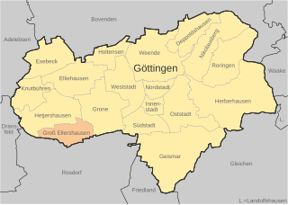
Groß Ellershausen
- human settlement in Germany
Hiking in Groß Ellershausen
Groß Ellershausen is a small village located in Lower Saxony, Germany, and is part of the larger municipality of Einbeck. The area around Groß Ellershausen offers some beautiful opportunities for hiking, characterized by picturesque landscapes, forests, and rolling hills typical of the region....
- Country:
- Postal Code: 37079
- Local Dialing Code: 0551
- Coordinates: 51° 31' 0" N, 9° 52' 0" E
- GPS tracks (wikiloc): [Link]
- AboveSeaLevel: 209 м m
- Area: 3.78 sq km