Ganterschwil (Ganterschwil)
- former municipality of Switzerland in St. Gallen
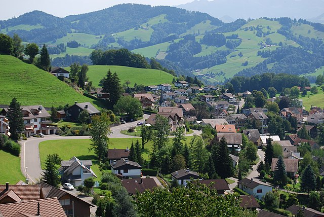
 Hiking in Ganterschwil
Ganterschwil, located in the scenic Toggenburg region of Switzerland, offers a variety of hiking opportunities that showcase the beautiful landscapes and natural features of the area. Here are some highlights for hiking in and around Ganterschwil:
Trails and Routes:
-
Panorama Trail: This hike provides stunning views of the surrounding mountains and valleys. It typically features well-marked paths that are suitable for hikers of all levels.
-
Forest Paths: The area is dotted with numerous forest trails, perfect for those looking for a serene walk surrounded by nature. These paths often lead through lush vegetation and might offer sightings of local wildlife.
-
Ridge Hikes: For more experienced hikers, the trails leading up to the higher ridges around Ganterschwil provide a challenging experience with rewarding panoramic views of the Toggenburg region.
-
Lake Hikes: Nearby lakes, such as the Sihlsee, offer additional options for hiking routes that circle the lakes, enhanced by picturesque water views and opportunities for birdwatching.
Accessibility:
- Most hiking trails in the area are well-marked and maintained. The Toggenburg region is generally accessible by public transport, making it easy to start your hike from various points.
Seasonal Considerations:
- Spring and Summer: The trails are lush and vibrant, with wildflowers in bloom and wildlife actively seen. This is prime hiking season.
- Autumn: Experience the beautiful fall foliage, which adds a picturesque quality to the hiking trails.
- Winter: Some trails may be suited for snowshoeing or winter hiking, depending on snow conditions.
Tips for Hiking in Ganterschwil:
- Map and Compass: Always bring a map or use a hiking app to track your route, especially if venturing into less familiar areas.
- Water and Snacks: Stay hydrated and bring snacks, as there may be limited facilities along some trails.
- Clothing: Dress in layers to accommodate changing weather, and always wear sturdy hiking boots.
- Respect Nature: Follow Leave No Trace principles to help preserve the natural beauty of the area.
Whether you are a novice hiker or seeking more challenging trails, Ganterschwil and its surroundings offer a rewarding hiking experience in the heart of Switzerland's mesmerizing landscape.
- Country:

- Postal Code: 9608
- Local Dialing Code: 071
- Licence Plate Code: SG
- Coordinates: 47° 22' 59" N, 9° 4' 59" E


- GPS tracks (wikiloc): [Link]
- AboveSeaLevel: 606 м m
- Area: 8.01 sq km
- Web site: http://www.ganterschwil.ch
- Wikipedia en: wiki(en)
- Wikipedia: wiki(de)
- Wikidata storage: Wikidata: Q65461
- Wikipedia Commons Category: [Link]
- Freebase ID: [/m/0gpq93]
- GeoNames ID: Alt: [2660665]
- VIAF ID: Alt: [237452925]
- GND ID: Alt: [4594745-4]
- HDS ID: [1394]
Shares border with regions:


Lütisburg
- municipality in Switzerland
Hiking in Lütisburg
Lütisburg is a charming area located in the canton of St. Gallen, Switzerland, known for its beautiful landscapes, rolling hills, and scenic trails. Hiking in Lütisburg offers a unique experience with a mix of nature, tranquility, and stunning views of the surrounding countryside and the Alps....
- Country:
- Postal Code: 9604
- Local Dialing Code: 071
- Licence Plate Code: SG
- Coordinates: 47° 23' 41" N, 9° 4' 52" E
- GPS tracks (wikiloc): [Link]
- AboveSeaLevel: 580 м m
- Area: 14.09 sq km
- Population: 1565
- Web site: [Link]

Oberhelfenschwil
- municipality in Switzerland
Hiking in Oberhelfenschwil
Oberhelfenschwil is a charming village located in the canton of St. Gallen, Switzerland. It is an ideal spot for hiking enthusiasts due to its picturesque landscapes, varied terrain, and well-marked trails. Here’s an overview of what you can expect when hiking in and around Oberhelfenschwil:...
- Country:
- Postal Code: 9621
- Local Dialing Code: 071
- Licence Plate Code: SG
- Coordinates: 47° 20' 43" N, 9° 6' 42" E
- GPS tracks (wikiloc): [Link]
- AboveSeaLevel: 792 м m
- Area: 12.68 sq km
- Population: 1267
- Web site: [Link]