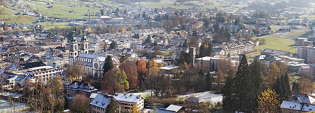
Canton of St. Gallen (Kanton St. Gallen)


- canton of Switzerland
 Hiking in Canton of St. Gallen
The Canton of St. Gallen, located in eastern Switzerland, is a fantastic destination for hiking enthusiasts, boasting a diverse range of trails that cater to various skill levels and interests. Here's an overview of what you can expect:
Natural Beauty
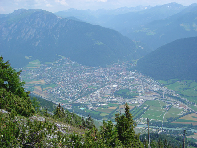
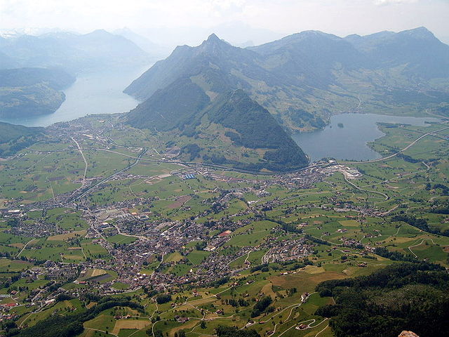
St. Gallen is characterized by its stunning landscapes, which include rolling hills, deep valleys, alpine meadows, and impressive mountains. The area is part of the eastern Swiss Alps, providing breathtaking views and opportunities for nature photography.
Trail Variety
-
Day Hikes: There are numerous well-marked trails that range from easy walks suitable for families to more challenging hikes for experienced adventurers. Recommended paths include:
- Rappenlochschlucht: A dramatic gorge trail that offers beautiful views of waterfalls and rock formations.
- Pizol: The Pizol mountain offers a popular hiking circuit, including a stunning lake at the summit.
-
Multiday Treks: The region also connects to the Appenzeller Trail, which allows for an extended hiking experience through picturesque villages and rich cultural landscapes.
Highlights
- Lake Constance: Although slightly outside the immediate hiking territory, the trails along the lake provide serene views and easy pathways.
- Wildlife: The area is home to a variety of wildlife, including chamois and mountain goats, making it a rewarding experience for animal watchers.
- Cultural Experience: Many trails pass through charming villages where you can experience traditional Swiss culture and hospitality.
Preparation Tips
- Weather: Always check the weather conditions before heading out, as alpine weather can change rapidly.
- Gear: Wear appropriate hiking boots and dress in layers to prepare for varying temperatures and weather conditions.
- Navigation: Although trails are well-marked, having a map or GPS can be helpful.
Accessibility
Many hiking paths are accessible via public transportation, making it easy to reach trailheads without needing a car. The local train and bus networks are efficient and cater well to outdoor enthusiasts.
Conclusion
Hiking in the Canton of St. Gallen offers something for everyone, from leisurely strolls to strenuous mountain treks. With its stunning natural scenery, well-maintained trails, and cultural richness, it’s an excellent choice for outdoor activities in Switzerland.
- Country:

- Capital: St. Gallen
- Licence Plate Code: SG
- Coordinates: 47° 20' 0" N, 9° 10' 0" E


- GPS tracks (wikiloc): [Link]
- AboveSeaLevel: 668 м m
- Area: 2030.75 sq km
- Population: 75538
- Web site: http://www.sg.ch
- Wikipedia en: wiki(en)
- Wikipedia: wiki(de)
- Wikidata storage: Wikidata: Q12746
- Wikipedia Commons Gallery: [Link]
- Wikipedia Commons Category: [Link]
- Freebase ID: [/m/01vbp2]
- GeoNames ID: Alt: [2658821]
- BnF ID: [11981215b]
- VIAF ID: Alt: [124913894]
- GND ID: Alt: [4051595-3]
- archINFORM location ID: [2906]
- Library of Congress authority ID: Alt: [n81042831]
- MusicBrainz area ID: [83811e81-c6de-42a5-8b28-231fbd545cc9]
- Quora topic ID: [Canton-of-St-Gallen]
- Encyclopædia Britannica Online ID: [place/Sankt-Gallen-canton-Switzerland]
- Gran Enciclopèdia Catalana ID: [0058747]
- HDS ID: [7390]
- ISNI: Alt: [0000 0001 0940 7446]
- NUTS code: [CH055]
- Klexikon article ID: [St._Gallen]
- STW Thesaurus for Economics ID: [16970-5]
- ISO 3166-2 code: CH-SG
- FIPS 10-4 (countries and regions): SZ15
Includes regions:


Rheintal Constituency
- district in Switzerland
Hiking in Rheintal Constituency
Rheintal, located in Switzerland, is part of the canton of St. Gallen and is known for its beautiful landscapes along the Rhine River. The area offers a range of hiking opportunities suitable for different experience levels. Here are some highlights for hiking in the Rheintal region:...
- Country:
- Capital: Altstätten
- Licence Plate Code: SG
- Coordinates: 47° 22' 40" N, 9° 34' 45" E
- GPS tracks (wikiloc): [Link]
- AboveSeaLevel: 412 м m
- Area: 138.37 sq km


Sarganserland Constituency
- district in Switzerland
Hiking in Sarganserland Constituency
Sarganserland, located in the eastern part of Switzerland, is a beautiful region that offers a variety of hiking opportunities set against a backdrop of stunning Swiss landscapes. The area is characterized by its picturesque mountains, valleys, and dense forests, making it a popular destination for outdoor enthusiasts....
- Country:
- Capital: Sargans
- Licence Plate Code: SG
- Coordinates: 47° 25' 35" N, 9° 22' 34" E
- GPS tracks (wikiloc): [Link]
- AboveSeaLevel: 490 м m
- Area: 517.92 sq km


St. Gallen Constituency
- district in Switzerland
Hiking in St. Gallen Constituency
St. Gallen (Wahlkreis), located in the eastern part of Switzerland, offers a variety of stunning hiking trails suitable for all levels, from casual walkers to experienced hikers. The region is characterized by picturesque landscapes including rolling hills, dense forests, and views of the nearby Alps....
- Country:
- Capital: St. Gallen
- Licence Plate Code: SG
- Coordinates: 47° 27' 48" N, 9° 23' 26" E
- GPS tracks (wikiloc): [Link]
- AboveSeaLevel: 602 м m
- Area: 157.54 sq km


See-Gaster Constituency
- district in Switzerland
Hiking in See-Gaster Constituency
See-Gaster is a beautiful region in Switzerland, located in the canton of St. Gallen. It's known for its stunning landscapes, featuring picturesque lakes, rolling hills, and scenic mountain views. Here are some highlights about hiking in the See-Gaster area:...
- Country:
- Capital: Rapperswil-Jona
- Licence Plate Code: SG
- Coordinates: 47° 13' 36" N, 8° 49' 6" E
- GPS tracks (wikiloc): [Link]
- AboveSeaLevel: 525 м m
- Area: 246.16 sq km


Wil Constituency
- district in Switzerland
Hiking in Wil Constituency
Hiking in the Wil district (Wahlkreis) offers a variety of beautiful trails and scenic landscapes, ideal for both experienced hikers and those looking for a more leisurely walk. Located in the Canton of St. Gallen in Switzerland, the area is characterized by rolling hills, dense forests, and picturesque views of the surrounding countryside....
- Country:
- Licence Plate Code: SG
- Coordinates: 47° 28' 0" N, 9° 3' 0" E
- GPS tracks (wikiloc): [Link]
- AboveSeaLevel: 603 м m
- Area: 145.29 sq km


Rorschach Constituency
- constituency of the canton of St. Gallen, Switzerland
Hiking in Rorschach Constituency
Rorschach, located in the canton of St. Gallen in Switzerland, offers some beautiful hiking opportunities thanks to its picturesque landscapes near Lake Constance and the surrounding hills and forests. Here are some highlights and tips for hiking in the Rorschach area:...
- Country:
- Capital: Rorschach
- Licence Plate Code: SG
- Coordinates: 47° 27' 59" N, 9° 26' 33" E
- GPS tracks (wikiloc): [Link]
- AboveSeaLevel: 529 м m
- Area: 50.37 sq km


Toggenburg Constituency
- district in Switzerland
Hiking in Toggenburg Constituency
Toggenburg is a beautiful region located in the canton of St. Gallen in Switzerland, renowned for its picturesque landscapes, charming villages, and excellent hiking opportunities. Here are some highlights and tips for hiking in Toggenburg:...
- Country:
- Capital: Lichtensteig
- Licence Plate Code: SG
- Coordinates: 47° 17' 40" N, 9° 10' 22" E
- GPS tracks (wikiloc): [Link]
- AboveSeaLevel: 968 м m
- Area: 488.75 sq km


Werdenberg Constituency
- district in Switzerland
Hiking in Werdenberg Constituency
Werdenberg, located in the northeastern part of Switzerland, is a picturesque area ideal for hiking enthusiasts. Known for its scenic beauty, medieval architecture, and varied terrain, it offers numerous trails suitable for different skill levels....
- Country:
- Licence Plate Code: SG
- Coordinates: 47° 10' 10" N, 9° 27' 41" E
- GPS tracks (wikiloc): [Link]
- AboveSeaLevel: 444 м m
- Area: 206.48 sq km
Shares border with regions:
Glarus
- canton of Switzerland
Hiking in Glarus
The Canton of Glarus, located in central Switzerland, is a stunning destination for hikers, offering a variety of trails that cater to different skill levels. Nestled between the rugged Alps and picturesque valleys, the region is known for its breathtaking landscapes, diverse flora and fauna, and charming villages....
- Country:
- Capital: Glarus
- Licence Plate Code: GL
- Coordinates: 46° 59' 0" N, 9° 4' 0" E
- GPS tracks (wikiloc): [Link]
- AboveSeaLevel: 472 м m
- Area: 685.3 sq km
- Population: 40000
- Web site: [Link]
Graubünden
- canton of Switzerland
Hiking in Graubünden
The Canton of Grisons, or Graubünden, is a breathtaking region in Switzerland known for its stunning landscapes, diverse hiking trails, and rich cultural heritage. Here are some highlights of hiking in this beautiful area:...
- Country:
- Capital: Chur
- Licence Plate Code: GR
- Coordinates: 46° 45' 0" N, 9° 30' 0" E
- GPS tracks (wikiloc): [Link]
- AboveSeaLevel: 585 м m
- Area: 7105.39 sq km
- Web site: [Link]

canton of Zürich
- canton of Switzerland
Hiking in canton of Zürich
The Canton of Zürich offers a rich variety of hiking opportunities, suitable for all skill levels and preferences. Here are some highlights and tips for hiking in this region:...
- Country:
- Capital: Zürich
- Licence Plate Code: ZH
- Coordinates: 47° 0' 0" N, 9° 0' 0" E
- GPS tracks (wikiloc): [Link]
- AboveSeaLevel: 408 м m
- Area: 1729 sq km
- Population: 1408575
- Web site: [Link]


Appenzell Ausserrhoden
- canton of Switzerland
Hiking in Appenzell Ausserrhoden
Hiking in the Canton of Appenzell Ausserrhoden offers stunning landscapes, picturesque villages, and well-marked trails that cater to various skill levels. This region in Switzerland is known for its rolling hills, picturesque mountains, and scenic views of the surrounding areas....
- Country:
- Capital: Trogen
- Licence Plate Code: AR
- Coordinates: 47° 3' 0" N, 9° 1' 0" E
- GPS tracks (wikiloc): [Link]
- AboveSeaLevel: 771 м m
- Area: 242.84 sq km
- Web site: [Link]


Appenzell Innerrhoden
- canton of Switzerland
Hiking in Appenzell Innerrhoden
Hiking in the Canton of Appenzell Innerrhoden, located in eastern Switzerland, offers a unique opportunity to explore stunning landscapes, rich culture, and well-maintained trails. Here are some highlights and tips for hiking in this picturesque region:...
- Country:
- Licence Plate Code: AI
- Coordinates: 47° 18' 0" N, 9° 24' 0" E
- GPS tracks (wikiloc): [Link]
- AboveSeaLevel: 780 м m
- Area: 172.48 sq km
- Web site: [Link]

Schwyz
- canton of Switzerland
Hiking in Schwyz
Hiking in the Canton of Schwyz in Switzerland offers a fantastic blend of stunning landscapes, rich cultural history, and well-maintained trails. The region features a variety of terrains, including mountains, lakes, and picturesque villages, making it a great destination for both novice and experienced hikers....
- Country:
- Capital: Schwyz
- Licence Plate Code: SZ
- Coordinates: 47° 4' 0" N, 8° 45' 0" E
- GPS tracks (wikiloc): [Link]
- AboveSeaLevel: 516 м m
- Area: 907.88 sq km
- Population: 155863
- Web site: [Link]


Thurgau
- canton of Switzerland
Hiking in Thurgau
The Canton of Thurgau in Switzerland is an excellent destination for hiking enthusiasts. Known for its picturesque landscapes, rolling hills, lush vineyards, and beautiful lakes, the region offers a variety of trails suitable for all skill levels. Here are some highlights of hiking in Thurgau:...
- Country:
- Capital: Frauenfeld
- Licence Plate Code: TG
- Coordinates: 47° 35' 0" N, 9° 4' 0" E
- GPS tracks (wikiloc): [Link]
- AboveSeaLevel: 417 м m
- Area: 991.77 sq km
- Web site: [Link]


Vorarlberg
- federal state of Austria
Hiking in Vorarlberg
Vorarlberg, the westernmost province of Austria, is a fantastic destination for hiking enthusiasts. Nestled between the Alps and the Rhine River, it offers a diverse landscape with breathtaking views, lush valleys, and well-marked trails catering to various skill levels....
- Country:

- Capital: Bregenz
- Coordinates: 47° 14' 37" N, 9° 53' 38" E
- GPS tracks (wikiloc): [Link]
- AboveSeaLevel: 1063 м m
- Area: 2601.48 sq km
- Population: 388711
- Web site: [Link]


Bavaria
- state in Germany
Hiking in Bavaria
Hiking in Bavaria is a fantastic experience, offering a diverse range of landscapes, stunning views, and well-marked trails. Here are some key highlights and tips for hiking in Bavaria:...
- Country:

- Capital: Munich
- Coordinates: 48° 46' 39" N, 11° 25' 52" E
- GPS tracks (wikiloc): [Link]
- AboveSeaLevel: 503 м m
- Area: 70551 sq km
- Population: 12930751
- Web site: [Link]