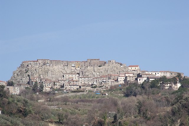
Gavorrano (Gavorrano)
.svg)
- Italian comune
 Hiking in Gavorrano
Gavorrano, located in the province of Grosseto in Tuscany, Italy, is surrounded by rich natural landscapes and offers various hiking opportunities for outdoor enthusiasts. The region is known for its scenic hills, Mediterranean vegetation, and historical sites, making it a great destination for hiking.
Hiking Trails and Highlights:
-
Natural Parks and Reserves:
- Gavorrano is close to the Maremma Natural Park, which is renowned for its diverse flora and fauna, stunning coastal views, and sandy beaches. There are multiple trails here catering to different skill levels.
-
Views and Landscapes:
- Many trails offer breathtaking views of the surrounding countryside, including olive groves, vineyards, and the beautiful Tyrrhenian Sea in the distance.
-
Historical Significance:
- While hiking, you can also explore the historical sites in Gavorrano, such as the ancient mining areas that were active during the Etruscan and Roman periods. The ruins and remnants of these sites are often integrated into the hiking trails.
-
Cultural Experience:
- The trails often lead through charming villages where you can experience Tuscan culture, local cuisine, and traditions. Don’t miss out on trying local wines and delicacies.
-
Trail Difficulty:
- The hiking trails in the Gavorrano area range from easy walks suitable for families to more challenging hikes for experienced trekkers. Always check the trail difficulty before setting out.
Preparing for Your Hike:
-
Best Time to Hike: Spring and autumn are ideal for hiking in Tuscany due to mild weather. Summer can be hot, so early morning hikes are recommended.
-
Gear: Wear comfortable hiking shoes, and bring plenty of water, sunscreen, and snacks. A map or GPS device is also advisable, as well as a first-aid kit.
-
Local Guides: Consider hiring a local guide for a more enriching experience; they can offer insights into the area’s ecology and history.
-
Safety: Always inform someone about your plans, especially if hiking alone. Check weather conditions before heading out.
With proper preparation, hiking in Gavorrano can be a rewarding way to explore the beautiful Tuscan landscape while enjoying nature and cultural heritage.
- Country:

- Postal Code: 58023
- Local Dialing Code: 0566
- Licence Plate Code: GR
- Coordinates: 42° 55' 30" N, 10° 54' 30" E


- GPS tracks (wikiloc): [Link]
- AboveSeaLevel: 273 м m
- Area: 163.98 sq km
- Population: 8567
- Web site: http://www.comune.gavorrano.gr.it/
- Wikipedia en: wiki(en)
- Wikipedia: wiki(it)
- Wikidata storage: Wikidata: Q188598
- Wikipedia Commons Gallery: [Link]
- Wikipedia Commons Category: [Link]
- Freebase ID: [/m/0gm1cl]
- GeoNames ID: Alt: [6540488]
- VIAF ID: Alt: [241867198]
- OSM relation ID: [42222]
- GND ID: Alt: [4588780-9]
- TGN ID: [1044778]
- UN/LOCODE: [ITGSR]
- Digital Atlas of the Roman Empire ID: [42323]
- ISTAT ID: 053010
- Italian cadastre code: D948
Shares border with regions:


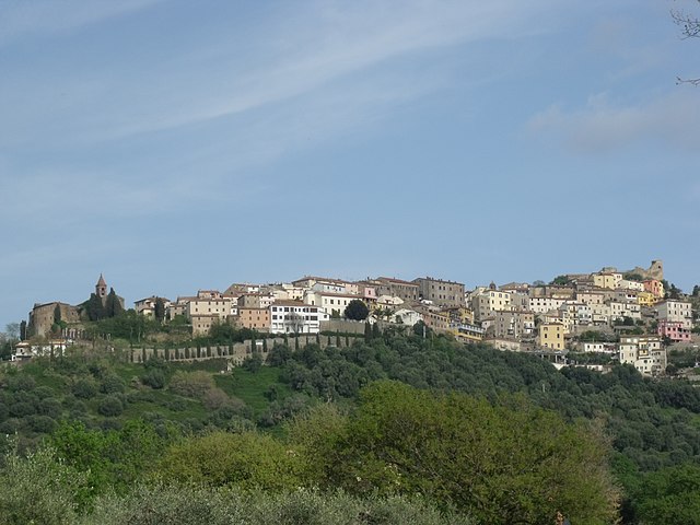
Castiglione della Pescaia
- Italian comune
Hiking in Castiglione della Pescaia
Castiglione della Pescaia, located in Tuscany, Italy, is a charming coastal town surrounded by beautiful natural landscapes, making it a fantastic destination for hiking enthusiasts. Here are some key points to consider when hiking in this area:...
- Country:
- Postal Code: 58043
- Local Dialing Code: 0564
- Licence Plate Code: GR
- Coordinates: 42° 45' 56" N, 10° 52' 51" E
- GPS tracks (wikiloc): [Link]
- AboveSeaLevel: 4 м m
- Area: 209.28 sq km
- Population: 7289
- Web site: [Link]


Massa Marittima
- Italian comune
Hiking in Massa Marittima
Massa Marittima is a charming medieval town located in Tuscany, Italy, and it's surrounded by beautiful landscapes that are ideal for hiking. The region offers a variety of trails, suitable for different skill levels, ranging from easy walks to more challenging hikes. Here are some key highlights about hiking in the area:...
- Country:
- Postal Code: 58024
- Local Dialing Code: 0566
- Licence Plate Code: GR
- Coordinates: 43° 3' 0" N, 10° 53' 37" E
- GPS tracks (wikiloc): [Link]
- AboveSeaLevel: 380 м m
- Area: 283.45 sq km
- Population: 8286
- Web site: [Link]

Roccastrada
- Italian comune
Hiking in Roccastrada
Roccastrada, located in the southern part of the Tuscany region in Italy, is an excellent destination for hiking enthusiasts. The area is characterized by its beautiful landscapes, rolling hills, and rich natural and cultural heritage. Here are some highlights to consider when hiking in Roccastrada:...
- Country:
- Postal Code: 58036
- Local Dialing Code: 0564
- Licence Plate Code: GR
- Coordinates: 43° 0' 35" N, 11° 10' 6" E
- GPS tracks (wikiloc): [Link]
- AboveSeaLevel: 475 м m
- Area: 284.47 sq km
- Population: 9074
- Web site: [Link]
Scarlino
- Italian comune
Hiking in Scarlino
Scarlino, located in the Maremma region of Tuscany, Italy, is a beautiful area perfect for hiking enthusiasts. The landscape features rolling hills, Mediterranean vegetation, and stunning views of the coastline, making it a great destination for outdoor activities....
- Country:
- Postal Code: 58020
- Local Dialing Code: 0566
- Licence Plate Code: GR
- Coordinates: 42° 54' 29" N, 10° 51' 3" E
- GPS tracks (wikiloc): [Link]
- AboveSeaLevel: 229 м m
- Area: 88.29 sq km
- Population: 3884
- Web site: [Link]


Grosseto
- Italian comune
Hiking in Grosseto
Grosseto, located in the picturesque region of Tuscany, Italy, offers stunning landscapes and a variety of hiking opportunities that cater to both novice and experienced hikers. Here are some highlights and tips for hiking in this beautiful area:...
- Country:
- Postal Code: 58100
- Local Dialing Code: 0564
- Licence Plate Code: GR
- Coordinates: 42° 46' 20" N, 11° 6' 32" E
- GPS tracks (wikiloc): [Link]
- AboveSeaLevel: 10 м m
- Area: 473.55 sq km
- Population: 82036
- Web site: [Link]