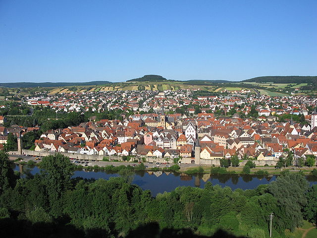
Gemünden am Main (Gemünden am Main)

- municipality in Germany
 Hiking in Gemünden am Main
Gemünden am Main, located in Bavaria, Germany, is surrounded by scenic landscapes, making it a great destination for hiking enthusiasts. Here are some highlights and tips about hiking in this area:
Scenic Trails
-
Main-Radweg: This cycling and hiking path runs along the Main River, offering picturesque views of the river and surrounding countryside. Portions of this trail are suitable for leisurely hikes.
-
Spessart Nature Park: Just a short distance from Gemünden, this nature park features a variety of trails through dense forests, rolling hills, and charming villages. The diverse flora and fauna make it an exciting area for hiking.
-
Hiking Routes: The region has marked hiking routes, including circular trails that vary in length and difficulty. Popular trails include routes to the nearby hills and wooded areas that provide panoramic views of the Main Valley.
Highlights
- Historical Sites: Along your hike, you might encounter quaint villages, historical ruins, and ancient trees, enriching your hiking experience with local culture and history.
- Wildlife Watching: The Spessart region is known for its rich wildlife, so keep an eye out for deer, wild boar, and various bird species.
Hiking Tips
- Gear: Wear appropriate hiking shoes with good grip, and carry a backpack with essentials, including water, snacks, and a first-aid kit.
- Map & Navigation: Make sure to have a map or download hiking apps that provide GPS tracking, especially if you plan to explore off the beaten path.
- Weather Check: The weather can change rapidly, so check the forecast before you head out and dress in layers.
- Local Resources: Consider stopping by the local tourist information center for maps, advice, and tips on current trail conditions.
Accessibility
Gemünden am Main is well-connected by public transport, making it easy to reach trailheads. If you're coming from larger cities like Würzburg or Frankfurt, you can take the train, adding convenience to your hiking adventure.
Whether you're a beginner looking for short walks or an experienced hiker seeking a challenge, Gemünden am Main offers a tranquil hiking experience in a beautiful setting. Enjoy your hike!
- Country:

- Postal Code: 97737
- Local Dialing Code: 09351
- Coordinates: 50° 2' 59" N, 9° 42' 20" E


- GPS tracks (wikiloc): [Link]
- AboveSeaLevel: 160 м m
- Area: 75.09 sq km
- Population: 10050
- Web site: http://www.stadt-gemuenden.de
- Wikipedia en: wiki(en)
- Wikipedia: wiki(de)
- Wikidata storage: Wikidata: Q505332
- Wikipedia Commons Category: [Link]
- Freebase ID: [/m/0dxtpr]
- GeoNames ID: Alt: [2921379]
- VIAF ID: Alt: [132646702]
- OSM relation ID: [349450]
- GND ID: Alt: [4092794-5]
- archINFORM location ID: [14748]
- Library of Congress authority ID: Alt: [n89146829]
- MusicBrainz area ID: [88fd55c6-3d0d-4fb3-8c5f-d7c54d6c4889]
- Historical Gazetteer (GOV) ID: [GEMAINJO40UB]
- Bavarikon ID: [ODB_A00000432]
- German municipality key: 09677131
Includes regions:
Hofstetten
- Ortsteil of Gemünden am Main
Hiking in Hofstetten
Hofstetten, part of the municipality of Gemünden am Main in Bavaria, Germany, offers a charming setting for hiking enthusiasts. The region is characterized by its picturesque landscapes, including the Main river, lush forests, and rolling hills, making it an attractive destination for outdoor activities....
- Country:
- Coordinates: 50° 3' 23" N, 9° 39' 29" E
- GPS tracks (wikiloc): [Link]
Kleinwernfeld
- Ortsteil of Gemünden am Main
Hiking in Kleinwernfeld
Kleinwernfeld, while it may not be as widely known as some major hiking destinations, likely offers a charming landscape ideal for nature enthusiasts. The region is typically characterized by scenic views, forested trails, and possibly some local wildlife, making it an attractive option for hikers looking for a peaceful experience away from the hustle and bustle of more popular trails....
- Country:
- Postal Code: 97737
- Coordinates: 50° 1' 35" N, 9° 43' 14" E
- GPS tracks (wikiloc): [Link]
- AboveSeaLevel: 150 м m
Seifriedsburg
- Ortsteil of Gemünden am Main
Hiking in Seifriedsburg
Seifriedsburg, a small area in Germany, offers a variety of hiking opportunities that cater to different skill levels and preferences. The region is surrounded by picturesque landscapes, rolling hills, and lush forests, making it a perfect destination for nature enthusiasts....
- Country:
- Postal Code: 97737
- Coordinates: 50° 4' 26" N, 9° 44' 50" E
- GPS tracks (wikiloc): [Link]
- AboveSeaLevel: 286 м m
Hohenroth
- Ortsteil of Gemünden am Main
Hiking in Hohenroth
Hohenroth, a district of Gemünden am Main in Bavaria, Germany, offers picturesque landscapes and scenic trails, making it an ideal location for hiking enthusiasts. Here are some key features and suggestions for hiking in this area:...
- Country:
- Coordinates: 50° 5' 11" N, 9° 39' 44" E
- GPS tracks (wikiloc): [Link]
Wernfeld
- Ortsteil of Gemünden am Main
Hiking in Wernfeld
Wernfeld, located in the district of Main-Spessart in Bavaria, Germany, is a charming area known for its picturesque landscapes and suitable hiking opportunities. The region is characterized by rolling hills, dense forests, and scenic views of the countryside, making it an ideal spot for outdoor activities....
- Country:
- Postal Code: 97737
- Local Dialing Code: 09351
- Coordinates: 50° 1' 31" N, 9° 43' 49" E
- GPS tracks (wikiloc): [Link]
- AboveSeaLevel: 169 м m
Aschenroth
- Ortsteil of Gemünden am Main
Hiking in Aschenroth
Aschenroth, a small village located in Germany, offers charming hiking opportunities in the surrounding areas. The region is characterized by its scenic landscapes, wooded trails, and proximity to natural features that appeal to hikers of all levels....
- Country:
Gemünden
- Ortsteil of Gemünden am Main
Hiking in Gemünden
Gemünden am Main is a picturesque town located in Bavaria, Germany, and is surrounded by beautiful landscapes that make it an excellent destination for hiking enthusiasts. The region offers a variety of trails that cater to different skill levels, from gentle walks suitable for families to more challenging hikes for seasoned adventurers....
- Country:
- Population: 4515
Harrbach
- Ortsteil of Gemünden am Main
Hiking in Harrbach
Harrbach is located in Germany and is known for its picturesque landscapes and hiking opportunities. While it may not be one of the most well-known hiking spots, the region offers a blend of scenic views, natural beauty, and potential wildlife sightings that make it appealing for hikers. Here are some aspects to consider if you're planning to hike in and around Harrbach:...
- Country:
Massenbuch
- Ortsteil of Gemünden am Main
Hiking in Massenbuch
Massenbuch is a picturesque village located in the region of Germany, known for its beautiful landscapes and outdoor activities, including hiking. While it may not be as widely recognized as other hiking destinations, it offers a range of trails suitable for hikers of all levels....
- Country:
Neutzenbrunn
- Ortsteil of Gemünden am Main
Hiking in Neutzenbrunn
Neutzenbrunn is not a widely recognized hiking destination, so it's possible you may be referring to a smaller, local area or a specific trail within a larger region. However, I can provide some general tips for hiking in lesser-known areas:...
- Country:
Reichenbuch
- Ortsteil of Gemünden am Main
Hiking in Reichenbuch
Reichenbuch is a small village in the German state of Hesse, nestled within the picturesque landscapes of the Odenwald region. While it may not be as widely known as some other hiking destinations, it offers numerous opportunities for hikers and nature lovers to explore....
- Country:
Schönau
- Ortsteil of Gemünden am Main
Hiking in Schönau
Schönau is a scenic area ideal for hiking, nestled in the beautiful natural landscapes of Germany, particularly known for its proximity to the Berchtesgaden National Park in Bavaria. Here’s a breakdown of what you can expect when hiking in Schönau:...
- Country:
Schaippach
- Ortsteil of Gemünden am Main
Hiking in Schaippach
Schaippach is a picturesque village in Germany, part of the Bavarian region, which is known for its beautiful landscapes, rolling hills, and access to nature. Hiking in this area can be a delightful experience, offering various trails that cater to different skill levels and preferences....
- Country:
Adelsberg
- Ortsteil of Gemünden am Main
Hiking in Adelsberg
Adelsberg, part of Gemünden am Main in Bavaria, Germany, is surrounded by scenic landscapes that are perfect for hiking enthusiasts. The area features a mix of rolling hills, forests, and river views, making it an ideal location for a variety of hiking trails suitable for all experience levels....
- Country:
- Coordinates: 50° 2' 6" N, 9° 44' 21" E
- GPS tracks (wikiloc): [Link]
- AboveSeaLevel: 228 м m
Langenprozelten
- Ortsteil of Gemünden am Main
Hiking in Langenprozelten
Langenprozelten, a picturesque village located in the Bavarian region of Germany, offers a variety of hiking opportunities for outdoor enthusiasts. Nestled along the banks of the Main River and surrounded by beautiful landscapes, it's an ideal spot for both beginner and experienced hikers....
- Country:
- Postal Code: 97737
- Coordinates: 50° 3' 43" N, 9° 39' 25" E
- GPS tracks (wikiloc): [Link]
- AboveSeaLevel: 157 м m
- Population: 2000
Shares border with regions:
Langenprozeltener Forst
- unincorporated area in Germany
Hiking in Langenprozeltener Forst
Langenprozeltener Forst is a beautiful forested area located in the southern part of Germany, near the town of Langenprozelten. This region is popular among hikers for its serene landscapes, diverse flora and fauna, and well-maintained trails. Here are some key points to consider if you're planning to hike in Langenprozeltener Forst:...
- Country:
- Coordinates: 50° 4' 0" N, 9° 37' 40" E
- GPS tracks (wikiloc): [Link]
Ruppertshüttener Forst
- unincorporated area in Germany
Hiking in Ruppertshüttener Forst
Ruppertshüttener Forst, located in Germany, is a beautiful area for hiking enthusiasts. The forest is part of a larger network of natural landscapes, providing a range of trails suited for different skill levels, from leisurely walks to more challenging hikes....
- Country:
- Coordinates: 50° 5' 15" N, 9° 33' 49" E
- GPS tracks (wikiloc): [Link]

Lohr am Main
- town in Bavaria, Germany
Hiking in Lohr am Main
Lohr am Main, located in Bavaria, Germany, is a picturesque town that offers beautiful hiking opportunities amid stunning landscapes. The area surrounding Lohr is characterized by its scenic views of the Main River, lush forests, and rolling hills. Here are some highlights for hiking in and around Lohr am Main:...
- Country:
- Postal Code: 97816
- Local Dialing Code: 09352
- Licence Plate Code: MSP
- Coordinates: 49° 59' 37" N, 9° 34' 42" E
- GPS tracks (wikiloc): [Link]
- AboveSeaLevel: 167 м m
- Area: 90.44 sq km
- Population: 15719
- Web site: [Link]

Gräfendorf
- municipality of Germany
Hiking in Gräfendorf
Gräfendorf, located in Bavaria, Germany, is an excellent spot for hiking enthusiasts. Nestled in the scenic landscapes of the region, it offers a mix of lush forests, rolling hills, and picturesque views of the countryside. Here are some highlights and tips for hiking in the Gräfendorf area:...
- Country:
- Postal Code: 97782
- Local Dialing Code: 09357
- Licence Plate Code: MSP
- Coordinates: 50° 7' 0" N, 9° 45' 0" E
- GPS tracks (wikiloc): [Link]
- AboveSeaLevel: 333 м m
- Area: 45.30 sq km
- Population: 1452
- Web site: [Link]

Rieneck
- human settlement in Germany
Hiking in Rieneck
Rieneck is a charming town in Bavaria, Germany, surrounded by beautiful landscapes that offer fantastic hiking opportunities. The area features rolling hills, dense forests, and scenic views, making it an ideal destination for outdoor enthusiasts. Here are some highlights for hiking in and around Rieneck:...
- Country:
- Postal Code: 97794
- Local Dialing Code: 09354
- Licence Plate Code: MSP
- Coordinates: 50° 6' 0" N, 9° 38' 0" E
- GPS tracks (wikiloc): [Link]
- AboveSeaLevel: 182 м m
- Area: 26.20 sq km
- Population: 2096
- Web site: [Link]
Karlstadt am Main
- human settlement in Germany
Hiking in Karlstadt am Main
Karlstadt am Main, located in Bavaria, Germany, is a charming town that offers various hiking opportunities in picturesque landscapes, including nearby forests, rivers, and hills. Here are some details about hiking in and around Karlstadt am Main:...
- Country:
- Postal Code: 97753
- Local Dialing Code: 09359; 09353
- Coordinates: 49° 57' 37" N, 9° 46' 20" E
- GPS tracks (wikiloc): [Link]
- AboveSeaLevel: 163 м m
- Area: 98.11 sq km
- Population: 14885
- Web site: [Link]

Gössenheim
- municipality of Germany
Hiking in Gössenheim
Gössenheim is a charming village located in Bavaria, Germany, nestled near the beautiful Main River valley. Hiking in and around Gössenheim offers opportunities to explore picturesque landscapes, vineyards, and charming villages. Here are some highlights and tips for hiking in this area:...
- Country:
- Postal Code: 97780
- Local Dialing Code: 09358
- Licence Plate Code: MSP
- Coordinates: 50° 1' 9" N, 9° 46' 58" E
- GPS tracks (wikiloc): [Link]
- AboveSeaLevel: 172 м m
- Area: 11.50 sq km
- Population: 1167
- Web site: [Link]

Neuendorf
- municipality in Bavaria state, Germany
Hiking in Neuendorf
Neuendorf, located in Bavaria, Germany, is a charming village that offers various hiking opportunities for outdoor enthusiasts. The picturesque landscapes and lush greenery of the Bavarian countryside provide a perfect backdrop for hiking adventures....
- Country:
- Postal Code: 97788
- Local Dialing Code: 09351
- Licence Plate Code: MSP
- Coordinates: 50° 1' 57" N, 9° 38' 38" E
- GPS tracks (wikiloc): [Link]
- AboveSeaLevel: 156 м m
- Area: 9.65 sq km
- Population: 838
- Web site: [Link]

Karsbach
- municipality of Germany
Hiking in Karsbach
Karsbach is a charming municipality in the Lower Franconia region of Bavaria, Germany, and it offers a variety of hiking opportunities for enthusiasts of all levels. The area is characterized by beautiful landscapes, including rolling hills, forests, and scenic views that can make for a delightful hiking experience....
- Country:
- Postal Code: 97783
- Local Dialing Code: 09358
- Licence Plate Code: MSP
- Coordinates: 50° 3' 0" N, 9° 47' 0" E
- GPS tracks (wikiloc): [Link]
- AboveSeaLevel: 231 м m
- Area: 30.15 sq km
- Population: 1507
- Web site: [Link]