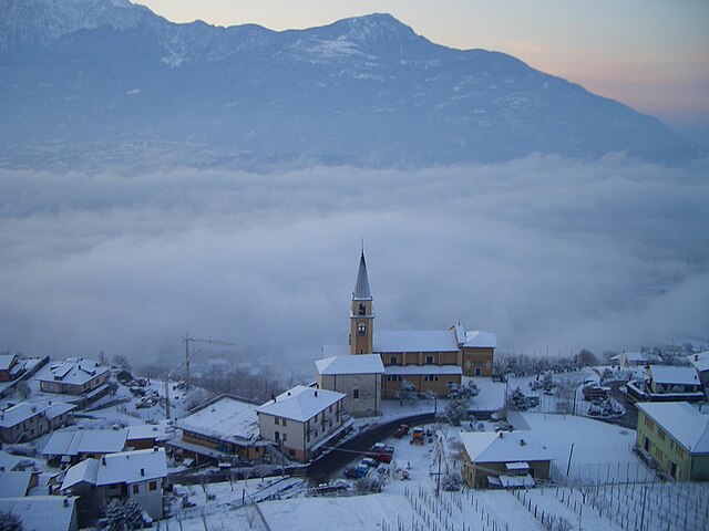
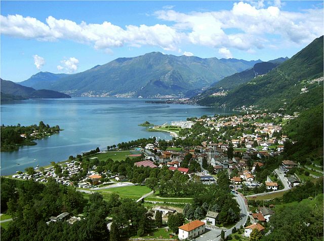
Gera Lario (Gera Lario)
.svg)
- Italian comune
 Hiking in Gera Lario
Gera Lario is a charming commune located on the northern shore of Lake Como in Italy. It offers stunning scenery, a mix of natural beauty, and cultural experiences, making it a delightful destination for hiking enthusiasts.
Hiking Trails
-
Sentiero del Viandante: This ancient trail follows the eastern shore of Lake Como and provides breathtaking views of the lake and the surrounding mountains. Although it doesn't pass directly through Gera Lario, it's accessible nearby and can be connected to various segments for a longer trek.
-
Monti di Gera: The hills surrounding Gera Lario offer several trails that lead to higher elevations. Hiking in this area will provide you with panoramic vistas of the lake and the chance to explore local flora and fauna.
-
Sentiero dei Pini: This path is suited for families and beginners. It winds through the woods, leading you to some picturesque viewpoints over the lake and the villages below.
Key Highlights
- Scenic Views: One of the biggest draws of hiking in Gera Lario is the stunning views of Lake Como, which can be enjoyed from various vantage points along the trails.
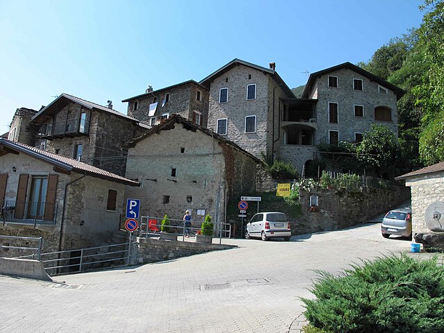
- Historical Sites: Along the trails, hikers may encounter historical features such as old churches and traditional stone houses, adding a cultural layer to your hiking experience.
- Wildlife: The area is rich in wildlife, so keep your eyes peeled for birds and other animals that inhabit the forests and hills.
Tips for Hiking in Gera Lario
- Best Time to Hike: The ideal times for hiking are spring and fall when the weather is mostly mild, and the landscapes are vibrant.
- Gear: Wear sturdy hiking boots and carry plenty of water, snacks, and sunscreen. In cooler months, layers are advisable due to temperature changes.
- Maps and Navigation: It’s wise to acquire a local hiking map or use a GPS app, as some trails can be less clearly marked.
Local Amenities
- After a day of hiking, Gera Lario offers a few local eateries where you can enjoy traditional Italian cuisine and relax by the lake.
- Accommodation options range from hotels to camping areas if you’d like to extend your stay.
Gera Lario is a fantastic destination for those who enjoy combining outdoor activities with breathtaking landscapes and local culture. Happy hiking!
- Country:

- Postal Code: 22010
- Local Dialing Code: 0344
- Licence Plate Code: CO
- Coordinates: 46° 10' 0" N, 9° 22' 0" E


- GPS tracks (wikiloc): [Link]
- AboveSeaLevel: 201 м m
- Area: 7.18 sq km
- Population: 1031
- Web site: http://www.comune.geralario.co.it
- Wikipedia en: wiki(en)
- Wikipedia: wiki(it)
- Wikidata storage: Wikidata: Q47375
- Wikipedia Commons Category: [Link]
- Freebase ID: [/m/0gj09m]
- GeoNames ID: Alt: [6537097]
- VIAF ID: Alt: [240606496]
- OSM relation ID: [46932]
- WOEID: [12678994]
- UN/LOCODE: [ITGLO]
- ISTAT ID: 013107
- Italian cadastre code: D974
Shares border with regions:
Piantedo
- Italian comune
Hiking in Piantedo
Piantedo is a small town located in the province of Sondrio, in the Lombardy region of northern Italy. It's surrounded by beautiful landscapes, including the stunning Alps, making it an excellent destination for hiking enthusiasts. Here are some highlights about hiking in and around Piantedo:...
- Country:
- Postal Code: 23010
- Local Dialing Code: 0342
- Licence Plate Code: SO
- Coordinates: 46° 8' 0" N, 9° 25' 0" E
- GPS tracks (wikiloc): [Link]
- AboveSeaLevel: 215 м m
- Area: 6.8 sq km
- Population: 1384
- Web site: [Link]
Dubino
- Italian comune
Hiking in Dubino
Dubino is a charming village in the province of Sondrio, located in the Lombardy region of northern Italy. Its picturesque setting, surrounded by mountains and lush landscapes, offers various hiking opportunities that cater to different skill levels. Here are some aspects to consider if you're planning to hike in the Dubino area:...
- Country:
- Postal Code: 23015
- Local Dialing Code: 0342
- Licence Plate Code: SO
- Coordinates: 46° 9' 0" N, 9° 27' 0" E
- GPS tracks (wikiloc): [Link]
- AboveSeaLevel: 223 м m
- Area: 13.24 sq km
- Population: 3715
- Web site: [Link]


Colico
- Italian comune
Hiking in Colico
Colico, located on the eastern shore of Lake Como in Italy's Lombardy region, offers a wonderful mix of beautiful scenery and hiking opportunities. The region is characterized by its stunning lake views, surrounding mountains, and charming villages....
- Country:
- Postal Code: 23823
- Local Dialing Code: 0341
- Licence Plate Code: LC
- Coordinates: 46° 8' 0" N, 9° 22' 0" E
- GPS tracks (wikiloc): [Link]
- AboveSeaLevel: 218 м m
- Area: 35.30 sq km
- Population: 7853
- Web site: [Link]

Vercana
- Italian comune
Hiking in Vercana
Vercana is a quaint village located on the western shore of Lake Como in Italy, known for its breathtaking views and proximity to various hiking trails. The area around Vercana offers a variety of hiking opportunities for all levels, from gentle lakeside walks to more challenging mountain hikes....
- Country:
- Postal Code: 22013
- Local Dialing Code: 0344
- Licence Plate Code: CO
- Coordinates: 46° 10' 0" N, 9° 20' 0" E
- GPS tracks (wikiloc): [Link]
- AboveSeaLevel: 345 м m
- Area: 15.01 sq km
- Population: 758
- Web site: [Link]

Sorico
- Italian comune
Hiking in Sorico
Sorico is a picturesque town located in the province of Sondrio, in the Lombardy region of northern Italy. It is positioned along the shores of Lake Como and offers stunning views of the surrounding mountains and lake, making it a great destination for hikers....
- Country:
- Postal Code: 22010
- Local Dialing Code: 0344
- Licence Plate Code: CO
- Coordinates: 46° 10' 20" N, 9° 22' 53" E
- GPS tracks (wikiloc): [Link]
- AboveSeaLevel: 201 м m
- Area: 24.44 sq km
- Population: 1270
- Web site: [Link]
Montemezzo
- Italian comune
Hiking in Montemezzo
Montemezzo is a small village located in the Lombardy region of Italy, situated on the eastern shore of Lake Como. It offers stunning views and a range of hiking opportunities that cater to different skill levels. Here are some key points to consider if you're planning a hiking trip in Montemezzo:...
- Country:
- Postal Code: 22010
- Local Dialing Code: 0344
- Licence Plate Code: CO
- Coordinates: 46° 10' 0" N, 9° 22' 0" E
- GPS tracks (wikiloc): [Link]
- AboveSeaLevel: 522 м m
- Area: 9.02 sq km
- Population: 228
- Web site: [Link]

Trezzone
- Italian comune
Hiking in Trezzone
Trezzone is a charming village located on the eastern shore of Lake Como in Italy, making it a fantastic destination for hiking enthusiasts. The area is surrounded by stunning natural landscapes, including mountains, lush forests, and picturesque views of the lake, providing various hiking opportunities for different skill levels....
- Country:
- Postal Code: 22010
- Local Dialing Code: 0344
- Licence Plate Code: CO
- Coordinates: 46° 10' 0" N, 9° 21' 0" E
- GPS tracks (wikiloc): [Link]
- AboveSeaLevel: 430 м m
- Area: 3.91 sq km
- Population: 230
- Web site: [Link]