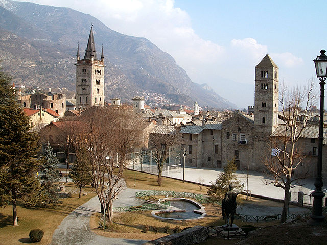
Giaglione (Giaglione)

- Italian comune
 Hiking in Giaglione
Giaglione is a picturesque village located in the Susa Valley of the Piedmont region in northwest Italy. It’s an ideal location for hiking enthusiasts, offering stunning views of the surrounding alpine landscape and numerous trails suitable for various skill levels.
Hiking Trails and Routes
-
Sentiero della Valle di Susa: This is a well-known trail that traverses the Susa Valley. It connects several villages and offers diverse terrains, from easy paths to more challenging hikes. The scenery includes lush forests, rivers, and views of rugged mountains.
-
Rocca di Fenestrelle: This historic fortress near Giaglione has trails that lead you up to it. The hike offers both historical insight and spectacular panoramic views of the valley and the surrounding peaks.
-
Monte Musinè: For those looking for a more challenging hike, the trails leading to Monte Musinè are rewarding. The summit provides breathtaking views, and on clear days, you can see as far as the Monviso and the Monte Rosa range.
Preparation and Tips
- Trail Conditions: Make sure to check the trail conditions before starting. Weather can change quickly in the mountains.
- Gear: Wear sturdy hiking boots and bring layers of clothing, as temperatures can vary significantly.
- Maps and Navigation: It’s wise to carry a map or a GPS device since some trails may not be well-marked.
- Stay Hydrated and Nourished: Bring enough water and snacks to keep your energy levels up, especially on longer hikes.
- Local Regulations: Be aware of any local regulations or guidelines for hikers, particularly in protected areas.
Best Time to Hike
The best times to hike in Giaglione are during spring (April to June) and fall (September to October) when temperatures are mild, and the trails are less crowded. Summer can be lovely but be prepared for occasional heat and higher foot traffic, while winter may be better suited for snow sports rather than hiking.
Wildlife and Flora
The area is home to a variety of wildlife, including deer, foxes, and many bird species, making it a great spot for nature lovers. The flora can range from wildflowers in the summer to stunning autumn foliage, adding to the beauty of your hiking experience.
Local Culture
While you’re in Giaglione, take some time to enjoy the local culture, sample the cuisine, and perhaps even connect with local hiking groups for guided experiences. The hospitality of the locals can enhance your experience in this beautiful region.
Happy hiking! If you have any specific questions or need further details about a particular trail or aspect of the hiking experience in Giaglione, feel free to ask!
- Country:

- Postal Code: 10050
- Local Dialing Code: 0122
- Licence Plate Code: TO
- Coordinates: 45° 8' 23" N, 7° 0' 51" E


- GPS tracks (wikiloc): [Link]
- AboveSeaLevel: 774 м m
- Area: 33.38 sq km
- Population: 619
- Web site: http://www.comune.giaglione.to.it/
- Wikipedia en: wiki(en)
- Wikipedia: wiki(it)
- Wikidata storage: Wikidata: Q9388
- Wikipedia Commons Category: [Link]
- Freebase ID: [/m/0g6wd4]
- GeoNames ID: Alt: [6543377]
- VIAF ID: Alt: [236155420]
- OSM relation ID: [44299]
- ISTAT ID: 001114
- Italian cadastre code: E009
Shares border with regions:

Susa
- Italian comune
Hiking in Susa
Susa, located in the Piedmont region of Italy, is a charming town nestled in the Susa Valley, surrounded by the stunning Alps. The area is known for its spectacular natural landscapes, historical sites, and a variety of hiking opportunities that cater to different skill levels....
- Country:
- Postal Code: 10059
- Local Dialing Code: 0122
- Licence Plate Code: TO
- Coordinates: 45° 8' 0" N, 7° 3' 0" E
- GPS tracks (wikiloc): [Link]
- AboveSeaLevel: 503 м m
- Area: 10.99 sq km
- Population: 6340
- Web site: [Link]


Venaus
- Italian comune
Hiking in Venaus
Venaus is a small village located in the Susa Valley of the Piedmont region in Italy. It is surrounded by the beautiful Alps, making it an excellent destination for hiking enthusiasts. Here are some highlights about hiking in and around Venaus:...
- Country:
- Postal Code: 10050
- Local Dialing Code: 0122
- Licence Plate Code: TO
- Coordinates: 45° 9' 0" N, 7° 1' 0" E
- GPS tracks (wikiloc): [Link]
- AboveSeaLevel: 604 м m
- Area: 19.14 sq km
- Population: 879
- Web site: [Link]


Bramans
- former commune in Savoie, France
Hiking in Bramans
Bramans is a charming village located in the Savoie region of the French Alps, known for its stunning natural landscapes and outdoor activities, including hiking. The area offers a variety of hiking trails that cater to different skill levels, making it a great destination for both beginner and experienced hikers....
- Country:

- Postal Code: 73500
- Coordinates: 45° 13' 25" N, 6° 46' 34" E
- GPS tracks (wikiloc): [Link]
- Area: 92.26 sq km
- Population: 435
- Web site: [Link]


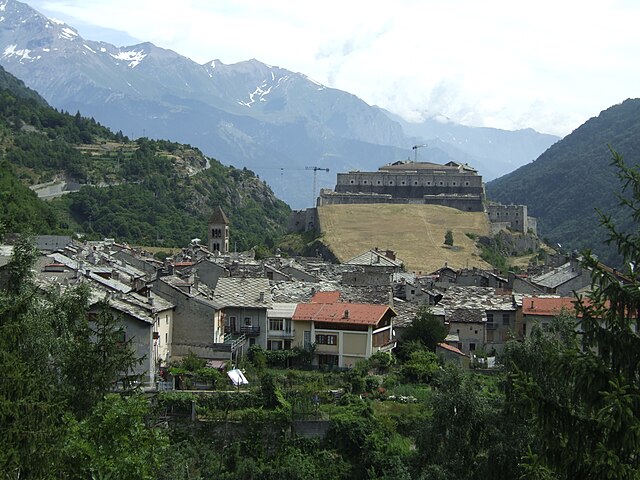
Chiomonte
- Italian comune
Hiking in Chiomonte
Chiomonte is a charming village located in the Susa Valley in the Piedmont region of Italy. Surrounded by the stunning landscape of the Italian Alps, it offers various hiking opportunities for outdoor enthusiasts....
- Country:
- Postal Code: 10050
- Local Dialing Code: 0122
- Licence Plate Code: TO
- Coordinates: 45° 7' 0" N, 6° 59' 0" E
- GPS tracks (wikiloc): [Link]
- AboveSeaLevel: 750 м m
- Area: 26.76 sq km
- Population: 883
- Web site: [Link]

Exilles
- Italian comune
Hiking in Exilles
Exilles, located in the Susa Valley in the Piedmont region of Italy, is surrounded by the stunning landscapes of the Alps, making it an excellent destination for hiking enthusiasts. Here are some highlights and tips for hiking in and around Exilles:...
- Country:
- Postal Code: 10050
- Local Dialing Code: 0122
- Licence Plate Code: TO
- Coordinates: 45° 6' 0" N, 6° 56' 0" E
- GPS tracks (wikiloc): [Link]
- AboveSeaLevel: 870 м m
- Area: 46.55 sq km
- Population: 260
- Web site: [Link]


Gravere
- Italian comune
Hiking in Gravere
Gravere is a small municipality located in the Susa Valley in the Piedmont region of northern Italy. It's known for its stunning natural scenery, which makes it a great spot for outdoor activities, including hiking. Here are some key points to consider if you’re planning to hike in Gravere:...
- Country:
- Postal Code: 10050
- Local Dialing Code: 0122
- Licence Plate Code: TO
- Coordinates: 45° 8' 0" N, 7° 1' 0" E
- GPS tracks (wikiloc): [Link]
- Area: 18.99 sq km
- Population: 671
- Web site: [Link]
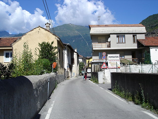
Mompantero
- Italian comune
Hiking in Mompantero
Mompantero, located in the province of Turin in the Piedmont region of Italy, is a charming destination for hikers looking to explore beautiful landscapes and enjoy outdoor activities. Nestled in the Susa Valley, this area is characterized by its stunning mountainous terrain, rich biodiversity, and picturesque views of the surrounding Alps....
- Country:
- Postal Code: 10059
- Local Dialing Code: 0122
- Licence Plate Code: TO
- Coordinates: 45° 9' 0" N, 7° 4' 0" E
- GPS tracks (wikiloc): [Link]
- AboveSeaLevel: 531 м m
- Area: 30.33 sq km
- Population: 646
- Web site: [Link]