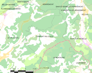
Girmont-Val-d'Ajol (Girmont-Val-d'Ajol)
- commune in Vosges, France
- Country:

- Postal Code: 88340
- Coordinates: 47° 57' 14" N, 6° 33' 41" E


- GPS tracks (wikiloc): [Link]
- Area: 16.67 sq km
- Population: 240
- Wikipedia en: wiki(en)
- Wikipedia: wiki(fr)
- Wikidata storage: Wikidata: Q899230
- Wikipedia Commons Category: [Link]
- Freebase ID: [/m/03qh83h]
- Freebase ID: [/m/03qh83h]
- GeoNames ID: Alt: [6445571]
- GeoNames ID: Alt: [6445571]
- SIREN number: [218802056]
- SIREN number: [218802056]
- BnF ID: [15279132q]
- BnF ID: [15279132q]
- VIAF ID: Alt: [136161668]
- VIAF ID: Alt: [136161668]
- Library of Congress authority ID: Alt: [n88678153]
- Library of Congress authority ID: Alt: [n88678153]
- INSEE municipality code: 88205
- INSEE municipality code: 88205
Shares border with regions:


Rupt-sur-Moselle
- commune in Vosges, France
- Country:

- Postal Code: 88360
- Coordinates: 47° 55' 36" N, 6° 39' 46" E


- GPS tracks (wikiloc): [Link]
- Area: 45.55 sq km
- Population: 3456
- Web site: [Link]


Le Val-d'Ajol
- commune in Vosges, France
- Country:

- Postal Code: 88340
- Coordinates: 47° 55' 30" N, 6° 29' 0" E


- GPS tracks (wikiloc): [Link]
- Area: 73.33 sq km
- Population: 3896
- Web site: [Link]


Saint-Étienne-lès-Remiremont
- commune in Vosges, France
- Country:

- Postal Code: 88200
- Coordinates: 48° 1' 25" N, 6° 36' 16" E


- GPS tracks (wikiloc): [Link]
- Area: 33.81 sq km
- Population: 3836
- Web site: [Link]


Dommartin-lès-Remiremont
- commune in Vosges, France
- Country:

- Postal Code: 88200
- Coordinates: 47° 59' 55" N, 6° 38' 35" E


- GPS tracks (wikiloc): [Link]
- Area: 21.08 sq km
- Population: 1892
- Web site: [Link]


La Longine
- commune in Haute-Saône, France
- Country:

- Postal Code: 70310
- Coordinates: 47° 53' 1" N, 6° 35' 27" E


- GPS tracks (wikiloc): [Link]
- Area: 12.4 sq km
- Population: 230


La Montagne
- commune in Haute-Saône, France
- Country:

- Postal Code: 70310
- Coordinates: 47° 55' 15" N, 6° 35' 30" E


- GPS tracks (wikiloc): [Link]
- Area: 12.61 sq km
- Population: 39
