Glénac (Glénac)

- former commune in Morbihan, France
- Country:

- Postal Code: 56200
- Coordinates: 47° 43' 37" N, 2° 8' 0" E


- GPS tracks (wikiloc): [Link]
- Area: 13.7 sq km
- Population: 898
- Wikipedia en: wiki(en)
- Wikipedia: wiki(fr)
- Wikidata storage: Wikidata: Q71304
- Wikipedia Commons Category: [Link]
- Freebase ID: [/m/03c4bs2]
- GeoNames ID: Alt: [3015821]
- BnF ID: [133290100]
- OSM relation ID: [128103]
- WOEID: [12644559]
- INSEE municipality code: 56064
Shares border with regions:


Peillac
- commune in Morbihan, France
- Country:
- Postal Code: 56220
- Coordinates: 47° 42' 48" N, 2° 13' 9" E
- GPS tracks (wikiloc): [Link]
- Area: 24.57 sq km
- Population: 1861
- Web site: [Link]

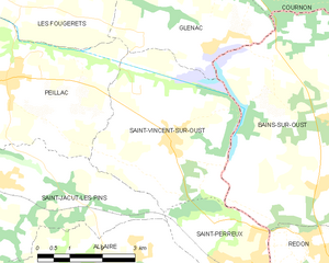
Saint-Vincent-sur-Oust
- commune in Morbihan, France
- Country:
- Postal Code: 56350
- Coordinates: 47° 41' 59" N, 2° 8' 47" E
- GPS tracks (wikiloc): [Link]
- Area: 15.66 sq km
- Population: 1446

Bains-sur-Oust
- commune in Ille-et-Vilaine, France
- Country:
- Postal Code: 35600
- Coordinates: 47° 42' 13" N, 2° 4' 17" E
- GPS tracks (wikiloc): [Link]
- Area: 44.63 sq km
- Population: 3414

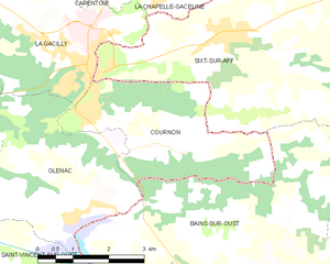
Cournon
- commune in Morbihan, France
- Country:
- Postal Code: 56200
- Coordinates: 47° 44' 47" N, 2° 6' 20" E
- GPS tracks (wikiloc): [Link]
- Area: 10.87 sq km
- Population: 770


La Gacilly
- former commune in Morbihan, France
- Country:
- Postal Code: 56200
- Coordinates: 47° 45' 54" N, 2° 7' 55" E
- GPS tracks (wikiloc): [Link]
- Area: 16.48 sq km
- Population: 2279
- Web site: [Link]

Les Fougerêts
- commune in Morbihan, France
- Country:
- Postal Code: 56200
- Coordinates: 47° 44' 25" N, 2° 12' 45" E
- GPS tracks (wikiloc): [Link]
- Area: 19.91 sq km
- Population: 934
- Web site: [Link]