Gmunden District (Bezirk Gmunden)

- district of Upper Austria
 Hiking in Gmunden District
Gmunden District, located in the Salzkammergut region of Austria, is a fantastic destination for hiking enthusiasts. The area is known for its stunning landscapes, including lakes, mountains, and lush forests. Here are some highlights and tips for hiking in the Gmunden District:
Key Features:
-
Traunsee Lake: One of the central attractions in the Gmunden District is Traunsee, a beautiful lake surrounded by mountains. The area offers various hiking trails with breathtaking views of the lake and its surroundings.
-
Traunstein Mountain: This iconic mountain towers over Traunsee and is a popular hiking destination. The ascent involves a mix of moderate to challenging trails, and the summit offers stunning panoramic views of the region.
-
Alpine Trails: The district features several well-marked alpine hiking paths that vary in difficulty, making it suitable for both beginners and experienced hikers. Trails often lead to picturesque viewpoints, hidden waterfalls, and quiet meadows.
-
Forstlauf Trail: This scenic trail takes you through beautiful forests and alongside the lake, ideal for a leisurely hike while enjoying nature. It’s a great option for families and casual hikers.
-
Culture and Nature: Besides hiking, the area offers cultural attractions such as historic towns like Gmunden and TraUNKirchen, showcasing traditional architecture and local cuisine.
Hiking Tips:
-
Seasonal Considerations: The best time for hiking in Gmunden District is typically late spring through early autumn. Winter hiking can be rewarding but requires proper gear due to snow conditions.
-
Trail Preparation: Always check trail maps and conditions before heading out. Local tourism offices can provide updated information on trail accessibility and any safety concerns.
-
Essential Gear: Ensure you have appropriate hiking gear, including sturdy footwear, enough water, snacks, a first-aid kit, and weather-appropriate clothing.
-
Respect Nature: Stick to marked trails to minimize your impact on the environment and ensure the preservation of the area.
-
Guided Hikes: If you are new to the area, consider joining a guided hike to learn more about the local flora, fauna, and history.
Hiking in the Gmunden District can be a memorable experience, thanks to its stunning natural beauty and a variety of trails that cater to all levels of hikers. Enjoy your adventure!
- Country:

- Capital: Gmunden
- Licence Plate Code: GM
- Coordinates: 47° 54' 4" N, 13° 47' 38" E


- GPS tracks (wikiloc): [Link]
- AboveSeaLevel: 1003 м m
- Area: 1432.62 sq km
- Web site: http://www.bh-gmunden.gv.at/
- Wikipedia en: wiki(en)
- Wikipedia: wiki(de)
- Wikidata storage: Wikidata: Q253221
- Wikipedia Commons Category: [Link]
- Freebase ID: [/m/0dmcv2]
- GeoNames ID: Alt: [2778435]
- VIAF ID: Alt: [159450504]
- GND ID: Alt: [4238251-8]
- archINFORM location ID: [14670]
- Library of Congress authority ID: Alt: [n80148166]
- Quora topic ID: [Gmunden]
Includes regions:
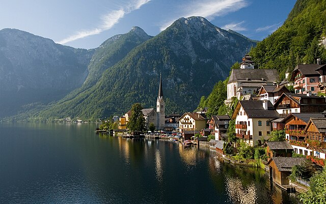
Hallstatt
- municipality in Austria
Hiking in Hallstatt
Hallstatt, located in Austria's Salzkammergut region, is renowned for its stunning scenery, charming village atmosphere, and rich history, making it a fantastic hiking destination. Here are some highlights and recommendations for hiking in Hallstatt:...
- Country:
- Postal Code: 4830
- Local Dialing Code: 06134
- Licence Plate Code: GM
- Coordinates: 47° 33' 21" N, 13° 38' 48" E
- GPS tracks (wikiloc): [Link]
- AboveSeaLevel: 511 м m
- Area: 59.8 sq km
- Population: 778
- Web site: [Link]
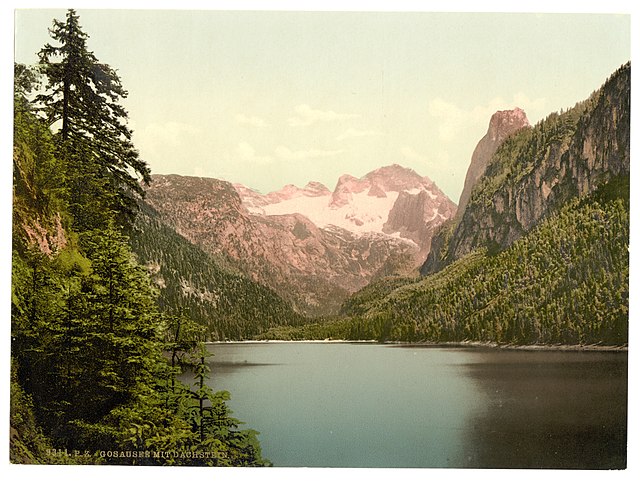
Gosau
- municipality in Austria
Hiking in Gosau
Gosau, located in the Salzkammergut region of Austria, is a stunning destination for hikers, offering a mix of breathtaking landscapes, diverse terrain, and a range of trails suitable for all skill levels. Nestled at the foot of the Dachstein mountains, the area boasts scenery featuring alpine meadows, crystal-clear lakes, and impressive peaks....
- Country:
- Local Dialing Code: 06136
- Licence Plate Code: GM
- Coordinates: 47° 35' 0" N, 13° 32' 0" E
- GPS tracks (wikiloc): [Link]
- AboveSeaLevel: 767 м m
- Area: 113.4 sq km
- Population: 1792
- Web site: [Link]
Pinsdorf
- municipality in Austria
Hiking in Pinsdorf
Pinsdorf, located near the Traunsee lake in Austria, offers a variety of scenic hiking opportunities that cater to different skill levels. The region is characterized by its beautiful alpine landscapes, lush forests, and stunning views of the lake and surrounding mountains....
- Country:
- Postal Code: 4812
- Local Dialing Code: 07612
- Licence Plate Code: GM
- Coordinates: 47° 55' 49" N, 13° 46' 1" E
- GPS tracks (wikiloc): [Link]
- AboveSeaLevel: 493 м m
- Area: 12.5 sq km
- Population: 3849
- Web site: [Link]

Bad Ischl
- location in Austria
Hiking in Bad Ischl
Bad Ischl, located in the Salzkammergut region of Austria, is a picturesque town surrounded by stunning alpine landscapes, making it an excellent destination for hiking enthusiasts. Here are some highlights of hiking in and around Bad Ischl:...
- Country:
- Postal Code: 4820
- Local Dialing Code: 06132
- Licence Plate Code: GM
- Coordinates: 47° 43' 13" N, 13° 38' 0" E
- GPS tracks (wikiloc): [Link]
- AboveSeaLevel: 468 м m
- Area: 162.8 sq km
- Population: 14133
- Web site: [Link]
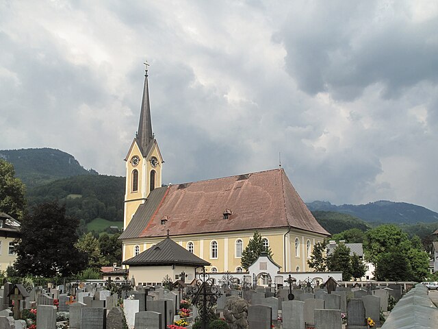
Bad Goisern
- market town in Austria
Hiking in Bad Goisern
Bad Goisern am Hallstättersee is a picturesque village located in Upper Austria, near the stunning Hallstättersee (Lake Hallstatt). It is an excellent starting point for a variety of hiking trails that showcase the region's natural beauty, including mountains, lakes, and lush forests. Here are some highlights and useful information about hiking in the area:...
- Country:
- Postal Code: 4822
- Local Dialing Code: 06135
- Licence Plate Code: GM
- Coordinates: 47° 38' 30" N, 13° 37' 0" E
- GPS tracks (wikiloc): [Link]
- AboveSeaLevel: 500 м m
- Area: 112.5 sq km
- Population: 7450
- Web site: [Link]

Traunkirchen
- municipality in Austria
Hiking in Traunkirchen
Traunkirchen, located on the shores of Lake Traunsee in Austria, is a beautiful destination for hiking enthusiasts. The region is characterized by stunning landscapes, lush forests, and panoramic views of the lake and surrounding mountains. Here are some highlights and tips for hiking in Traunkirchen:...
- Country:
- Postal Code: 4801
- Local Dialing Code: 07617
- Licence Plate Code: GM
- Coordinates: 47° 50' 45" N, 13° 47' 39" E
- GPS tracks (wikiloc): [Link]
- AboveSeaLevel: 422 м m
- Area: 18.37 sq km
- Population: 1624
- Web site: [Link]
Laakirchen
- municipality in Austria
Hiking in Laakirchen
Laakirchen, located in Austria, is a charming and picturesque town near the foothills of the Alps, making it a great spot for hiking enthusiasts. The surrounding region offers a variety of trails that cater to different skill levels, from gentle walks suitable for families to more challenging hikes for experienced trekkers....
- Country:
- Postal Code: 4663
- Local Dialing Code: 07613
- Licence Plate Code: GM
- Coordinates: 47° 58' 58" N, 13° 49' 27" E
- GPS tracks (wikiloc): [Link]
- AboveSeaLevel: 441 м m
- Area: 32.5 sq km
- Population: 9861
- Web site: [Link]
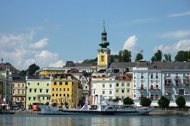
Gmunden
- municipality in Austria
Hiking in Gmunden
Gmunden, located in Austria's Salzkammergut region, is a beautiful destination for hiking enthusiasts. The area is known for its stunning landscapes, characterized by alpine scenery, picturesque lakes, and charming villages. Here are some highlights and tips for hiking in Gmunden:...
- Country:
- Postal Code: 4810
- Local Dialing Code: 07612
- Licence Plate Code: GM
- Coordinates: 47° 55' 5" N, 13° 47' 58" E
- GPS tracks (wikiloc): [Link]
- AboveSeaLevel: 425 м m
- Area: 63.49 sq km
- Population: 13191
- Web site: [Link]

Altmünster
- town in Austria
Hiking in Altmünster
Altmünster is a beautiful town located in the Salzkammergut region of Austria, known for its stunning landscapes and proximity to the Traunsee lake. Hiking in this area offers a variety of trails suitable for different skill levels, making it a great destination for both novice and experienced hikers....
- Country:
- Licence Plate Code: GM
- Coordinates: 47° 54' 0" N, 13° 46' 0" E
- GPS tracks (wikiloc): [Link]
- AboveSeaLevel: 442 м m
- Area: 79 sq km
- Population: 9793
- Web site: [Link]

St. Wolfgang im Salzkammergut
- municipality in Austria
Hiking in St. Wolfgang im Salzkammergut
St. Wolfgang im Salzkammergut is a beautiful destination for hiking enthusiasts, located in the stunning Austrian Salzkammergut region. The area is renowned for its picturesque lakes, rolling hills, and mountainous landscapes. Here are some highlights and tips for hiking in this incredible locale:...
- Country:
- Postal Code: 5360
- Local Dialing Code: 06138
- Licence Plate Code: GM
- Coordinates: 47° 44' 18" N, 13° 26' 53" E
- GPS tracks (wikiloc): [Link]
- AboveSeaLevel: 548 м m
- Area: 56.6 sq km
- Population: 2820
- Web site: [Link]

Obertraun
- municipality in Austria
Hiking in Obertraun
Obertraun, located in Austria's Salzkammergut region near the shores of Lake Hallstatt, is surrounded by stunning scenery and offers a variety of hiking options for all skill levels. The area is characterized by picturesque mountains, lush green valleys, and clear lakes, making it an ideal destination for hikers and nature enthusiasts....
- Country:
- Postal Code: 4831
- Local Dialing Code: 06131
- Licence Plate Code: GM
- Coordinates: 47° 33' 31" N, 13° 41' 1" E
- GPS tracks (wikiloc): [Link]
- AboveSeaLevel: 513 м m
- Area: 34 sq km
- Population: 738
- Web site: [Link]
Vorchdorf
- municipality in Austria
Hiking in Vorchdorf
Vorchdorf, located in Austria, is surrounded by beautiful landscapes that offer a variety of hiking opportunities. The area is characterized by its picturesque countryside, forests, and hills, making it ideal for both beginners and experienced hikers....
- Country:
- Postal Code: 4655
- Local Dialing Code: 07614
- Licence Plate Code: GM
- Coordinates: 48° 0' 15" N, 13° 55' 27" E
- GPS tracks (wikiloc): [Link]
- AboveSeaLevel: 414 м m
- Area: 47.7 sq km
- Population: 7475
- Web site: [Link]


Grünau im Almtal
- municipality in Austria
Hiking in Grünau im Almtal
Grünau im Almtal is a picturesque village located in the Austria's Tyrol region, known for its stunning natural beauty and excellent hiking opportunities. The area is part of the Salzkammergut lake region and offers a diverse range of trails suitable for hikers of all levels....
- Country:
- Postal Code: 4645
- Local Dialing Code: 07616
- Licence Plate Code: GM
- Coordinates: 47° 51' 10" N, 13° 57' 20" E
- GPS tracks (wikiloc): [Link]
- AboveSeaLevel: 528 м m
- Area: 230 sq km
- Population: 2064
- Web site: [Link]

Gschwandt
- municipality in Austria
Hiking in Gschwandt
Gschwandt is a charming village located in the Salzkammergut region of Austria, surrounded by beautiful landscapes, mountains, and lakes. It's a fantastic destination for hiking enthusiasts of all levels. Here are some key highlights and tips for hiking in the Gschwandt area:...
- Country:
- Postal Code: 4816
- Local Dialing Code: 07612
- Licence Plate Code: GM
- Coordinates: 47° 56' 6" N, 13° 50' 44" E
- GPS tracks (wikiloc): [Link]
- AboveSeaLevel: 523 м m
- Area: 16.78 sq km
- Population: 2750
- Web site: [Link]

Scharnstein
- municipality in Austria
Hiking in Scharnstein
Scharnstein is a picturesque village located in the Salzkammergut region of Austria, surrounded by stunning alpine scenery. It offers a variety of hiking opportunities for both beginners and experienced hikers. Here are some highlights to consider when planning a hiking trip in Scharnstein:...
- Country:
- Postal Code: 4644
- Local Dialing Code: 07615
- Licence Plate Code: GM
- Coordinates: 47° 54' 1" N, 13° 57' 39" E
- GPS tracks (wikiloc): [Link]
- AboveSeaLevel: 488 м m
- Area: 47.7 sq km
- Population: 4780
- Web site: [Link]
Ohlsdorf
- municipality in Austria
Hiking in Ohlsdorf
Ohlsdorf, located in Hamburg, Germany, is well-known for its beautiful natural landscapes and well-maintained parks. While it may not be a traditional hiking destination like some mountainous areas, there are still lovely walking and hiking opportunities in and around Ohlsdorf, particularly in the Ohlsdorf Cemetery and nearby parks....
- Country:
- Postal Code: 4694
- Local Dialing Code: 07612
- Licence Plate Code: GM
- Coordinates: 47° 57' 41" N, 13° 47' 34" E
- GPS tracks (wikiloc): [Link]
- AboveSeaLevel: 538 м m
- Area: 27.9 sq km
- Population: 5209
- Web site: [Link]

Roitham am Traunfall
- municipality in Austria
Hiking in Roitham am Traunfall
Roitham am Traunfall is a picturesque village located in Austria, near the Traun River. It offers a variety of hiking options, providing beautiful views of the surrounding nature and the unique landscapes of the region. Here are some aspects to consider when hiking in this area:...
- Country:
- Postal Code: 4661
- Local Dialing Code: 07613
- Licence Plate Code: GM
- Coordinates: 48° 1' 31" N, 13° 49' 21" E
- GPS tracks (wikiloc): [Link]
- AboveSeaLevel: 424 м m
- Area: 21.1 sq km
- Population: 2001
- Web site: [Link]
Sankt Konrad
- municipality in Austria
Hiking in Sankt Konrad
Sankt Konrad is a picturesque village in Austria, nestled in the Salzkammergut region, surrounded by stunning alpine scenery. It's an excellent location for hiking enthusiasts, offering a range of trails suitable for different skill levels. Here are some highlights for hiking in and around Sankt Konrad:...
- Country:
- Postal Code: 4817
- Local Dialing Code: 07615
- Licence Plate Code: GM
- Coordinates: 47° 54' 49" N, 13° 53' 2" E
- GPS tracks (wikiloc): [Link]
- AboveSeaLevel: 584 м m
- Area: 19.3 sq km
- Population: 1115
- Web site: [Link]


Kirchham
- municipality in Austria
Hiking in Kirchham
Kirchham, located in Austria, is a picturesque area that offers a variety of hiking opportunities suitable for different skill levels. Nestled in the scenic region of Upper Austria, Kirchham is surrounded by beautiful landscapes, including rolling hills, lush forests, and stunning views of the surrounding mountains....
- Country:
- Postal Code: 4656
- Local Dialing Code: 07619
- Licence Plate Code: GM
- Coordinates: 47° 58' 16" N, 13° 54' 0" E
- GPS tracks (wikiloc): [Link]
- AboveSeaLevel: 470 м m
- Area: 28.4 sq km
- Population: 2139
- Web site: [Link]

Ebensee
- municipality in Austria
Hiking in Ebensee
Ebensee, located in the Salzkammergut region of Austria, offers some stunning hiking opportunities, thanks to its picturesque landscapes, mountains, and lakes. Here are some highlights and tips for hiking in Ebensee:...
- Country:
- Postal Code: 4802
- Local Dialing Code: 06133
- Licence Plate Code: GM
- Coordinates: 47° 48' 30" N, 13° 46' 30" E
- GPS tracks (wikiloc): [Link]
- AboveSeaLevel: 443 м m
- Area: 194.5 sq km
- Population: 7717
- Web site: [Link]