Grünau im Almtal (Grünau im Almtal)
- municipality in Austria
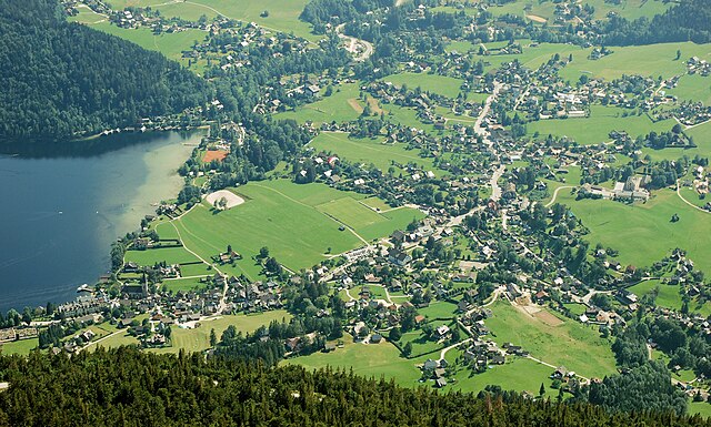
Grünau im Almtal is a picturesque village located in the Austria's Tyrol region, known for its stunning natural beauty and excellent hiking opportunities. The area is part of the Salzkammergut lake region and offers a diverse range of trails suitable for hikers of all levels.
Hiking Information
-
Trails and Routes:
- Almtaler Brautradition Trail: This is a circular route that showcases the local flora and fauna, along with cultural highlights of the region.
- Grünauer Schafberg: A moderate hike that takes you to a summit with spectacular views over the Almtal Valley.
- Lake Almsee Circuit: A scenic trail that circles the Almsee, a beautiful alpine lake ideal for leisurely walks.
-
Difficulty Levels:
- There are trails ranging from easy, family-friendly walks to more challenging routes for experienced hikers. Always check trail information for current conditions and difficulty ratings.
-
Best Time to Hike:
- The best months for hiking in the area are typically from late spring (May) to early autumn (September), when the weather is mild and the trails are generally dry.
-
Facilities:
- Many trails start from the village and are easily accessible. You can find local inns and restaurants where you can enjoy traditional Austrian cuisine post-hike.
- Make sure to carry enough water and snacks, as some trails may not have amenities along the way.
-
Safety Tips:
- Always wear appropriate hiking shoes and clothing suitable for the weather conditions.
- Bring a map or a GPS device, especially for more remote trails.
- Be mindful of wildlife and stick to marked paths to preserve the environment.
-
Tour Guides and Programs:
- If you’re unfamiliar with the area or want a more enriching experience, consider joining a local hiking group or hiring a guide. They can provide insights into the local culture, history, and ecology.
Conclusion
Grünau im Almtal offers a wonderful hiking experience for nature lovers. Whether you’re looking for a peaceful stroll around a serene lake or an adventurous climb with rewarding views, you’ll find the right trail in this beautiful alpine setting. Always ensure to check local resources for the latest trail conditions and enjoy your hike!
- Country:

- Postal Code: 4645
- Local Dialing Code: 07616
- Licence Plate Code: GM
- Coordinates: 47° 51' 10" N, 13° 57' 20" E


- GPS tracks (wikiloc): [Link]
- AboveSeaLevel: 528 м m
- Area: 230 sq km
- Population: 2064
- Web site: http://www.gruenau.at/
- Wikipedia en: wiki(en)
- Wikipedia: wiki(de)
- Wikidata storage: Wikidata: Q662096
- Wikipedia Commons Category: [Link]
- Freebase ID: [/m/05fvny]
- GeoNames ID: Alt: [2777459]
- BnF ID: [13613013w]
- VIAF ID: Alt: [245065523]
- GND ID: Alt: [4232856-1]
- archINFORM location ID: [12803]
- WOEID: [545245]
- Quora topic ID: [Grünau-Im-Almtal]
- Austrian municipality key: [40707]
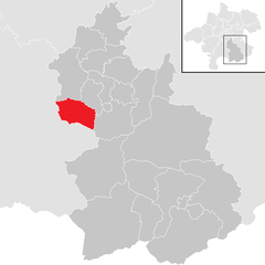
Shares border with regions:

Altaussee
- municipality in Austria
Altaussee, located in the picturesque Salzkammergut region of Austria, is a fantastic destination for hiking enthusiasts. Nestled among the stunning Dachstein mountains and nestled by the shores of Lake Altaussee, this area offers a diverse range of trails suitable for all levels of hikers....
- Country:

- Postal Code: 8992
- Local Dialing Code: 03622
- Licence Plate Code: LI
- Coordinates: 47° 38' 22" N, 13° 45' 48" E


- GPS tracks (wikiloc): [Link]
- AboveSeaLevel: 712 м m
- Area: 92 sq km
- Population: 1878
- Web site: [Link]

Gmunden
- municipality in Austria
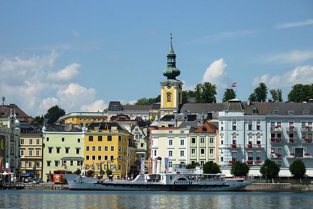
Gmunden, located in Austria's Salzkammergut region, is a beautiful destination for hiking enthusiasts. The area is known for its stunning landscapes, characterized by alpine scenery, picturesque lakes, and charming villages. Here are some highlights and tips for hiking in Gmunden:...
- Country:

- Postal Code: 4810
- Local Dialing Code: 07612
- Licence Plate Code: GM
- Coordinates: 47° 55' 5" N, 13° 47' 58" E


- GPS tracks (wikiloc): [Link]
- AboveSeaLevel: 425 м m
- Area: 63.49 sq km
- Population: 13191
- Web site: [Link]

Micheldorf in Oberösterreich
- municipality in Austria
 Hiking in Micheldorf in Oberösterreich
Micheldorf in Oberösterreich is a charming village located in the Upper Austria region, surrounded by beautiful landscapes that are perfect for hiking enthusiasts. Here’s what you can expect when hiking in this area:...
- Country:

- Postal Code: 4563
- Local Dialing Code: 07582
- Licence Plate Code: KI
- Coordinates: 47° 52' 41" N, 14° 8' 0" E


- GPS tracks (wikiloc): [Link]
- AboveSeaLevel: 465 м m
- Area: 50.32 sq km
- Population: 5814
- Web site: [Link]


Klaus an der Pyhrnbahn
- municipality in Austria
 Hiking in Klaus an der Pyhrnbahn
Klaus an der Pyhrnbahn is a picturesque village located in the Upper Austria region, surrounded by stunning natural landscapes, making it an excellent destination for hiking enthusiasts. Here are some key points about hiking in this area:...
- Country:

- Postal Code: 4564
- Local Dialing Code: 07585
- Licence Plate Code: KI
- Coordinates: 47° 49' 50" N, 14° 9' 29" E


- GPS tracks (wikiloc): [Link]
- AboveSeaLevel: 466 м m
- Area: 108 sq km
- Population: 1063
- Web site: [Link]


Hinterstoder
- municipality in Upper Austria, Austria
Hinterstoder, located in the stunning Salzkammergut region of Austria, is a fantastic destination for hikers of all skill levels. This small alpine village is surrounded by the beautiful peaks of the Totes Gebirge mountain range, offering a wide variety of hiking trails that take you through breathtaking landscapes, lush forests, and scenic alpine meadows....
- Country:

- Postal Code: 4573
- Local Dialing Code: 07564
- Licence Plate Code: KI
- Coordinates: 47° 41' 47" N, 14° 8' 58" E


- GPS tracks (wikiloc): [Link]
- AboveSeaLevel: 591 м m
- Area: 149.5 sq km
- Population: 910
- Web site: [Link]

Scharnstein
- municipality in Austria
Scharnstein is a picturesque village located in the Salzkammergut region of Austria, surrounded by stunning alpine scenery. It offers a variety of hiking opportunities for both beginners and experienced hikers. Here are some highlights to consider when planning a hiking trip in Scharnstein:...
- Country:

- Postal Code: 4644
- Local Dialing Code: 07615
- Licence Plate Code: GM
- Coordinates: 47° 54' 1" N, 13° 57' 39" E


- GPS tracks (wikiloc): [Link]
- AboveSeaLevel: 488 м m
- Area: 47.7 sq km
- Population: 4780
- Web site: [Link]


Steinbach am Ziehberg
- municipality in Austria
 Hiking in Steinbach am Ziehberg
Steinbach am Ziehberg, located in Austria, is a wonderful destination for hiking enthusiasts. Nestled in the stunning Salzkammergut region, it offers beautiful landscape features including mountains, forests, and meadows....
- Country:

- Postal Code: 4562
- Local Dialing Code: 07582
- Licence Plate Code: KI
- Coordinates: 47° 53' 32" N, 14° 2' 0" E


- GPS tracks (wikiloc): [Link]
- AboveSeaLevel: 547 м m
- Area: 34.8 sq km
- Population: 828
- Web site: [Link]

Grundlsee
- municipality in Austria
Grundlsee, located in Austria's Salzkammergut region, is a stunning destination for hiking enthusiasts. The area is renowned for its picturesque landscapes, crystal-clear lake, and impressive mountain backdrops. Here are some highlights and tips for hiking in Grundlsee:...
- Country:

- Postal Code: 8993
- Local Dialing Code: 03622
- Licence Plate Code: LI
- Coordinates: 47° 37' 36" N, 13° 50' 15" E


- GPS tracks (wikiloc): [Link]
- AboveSeaLevel: 732 м m
- Area: 153.22 sq km
- Population: 1199
- Web site: [Link]
