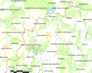
Gondenans-les-Moulins (Gondenans-les-Moulins)

- commune in Doubs, France
 Hiking in Gondenans-les-Moulins
Gondenans-les-Moulins, located in the Franche-Comté region of eastern France, is a charming village that offers several opportunities for hiking and enjoying the natural beauty of the surrounding countryside. Here are some key points about hiking in this area:
Scenic Trails
- Varied Terrain: The trails around Gondenans-les-Moulins feature diverse landscapes, including forests, meadows, and picturesque views of the Jura mountains.
- Local Routes: There are various marked trails suitable for different skill levels, from easy walks suitable for families to more challenging hikes for seasoned walkers.
Key Attractions
- Natural Beauty: Enjoy walking through lush forests and scenic farmland, with the chance to see local wildlife and plant species along the way.
- Cultural Landmarks: Some hiking routes may lead you to local heritage sites or offer views of traditional French countryside architecture.
Best Practices for Hiking
- Preparation: Make sure to wear suitable footwear and bring along essentials such as water, snacks, and a map or GPS device.
- Weather Considerations: Check the weather forecast before heading out, as conditions can change quickly, especially in mountainous areas.
- Respect Nature: Follow the Leave No Trace principles by not littering and staying on marked trails to preserve the natural environment.
Local Resources
- Visitor Centers: Check for any local hiking guides or visitor centers that may offer maps, details on trail conditions, and tips on the best hiking spots in the area.
- Community Events: Sometimes, local hiking clubs or organizations may organize group hikes, which can be a great way to explore the area with others.
Overall, Gondenans-les-Moulins is an inviting destination for hikers looking to experience the tranquility and beauty of the French countryside. Enjoy your adventure!
- Country:

- Postal Code: 25680
- Coordinates: 47° 28' 10" N, 6° 22' 54" E


- GPS tracks (wikiloc): [Link]
- Area: 3.93 sq km
- Population: 76
- Wikipedia en: wiki(en)
- Wikipedia: wiki(fr)
- Wikidata storage: Wikidata: Q836602
- Wikipedia Commons Category: [Link]
- Freebase ID: [/m/03mh9p5]
- Freebase ID: [/m/03mh9p5]
- GeoNames ID: Alt: [6429808]
- GeoNames ID: Alt: [6429808]
- SIREN number: [212502777]
- SIREN number: [212502777]
- BnF ID: [152525034]
- BnF ID: [152525034]
- INSEE municipality code: 25277
- INSEE municipality code: 25277
Shares border with regions:


Romain
- commune in Doubs, France
Hiking in Romain
Hiking in Romain, located in the Doubs department of France, offers a wonderful opportunity to explore the scenic beauty of the Franche-Comté region. Doubs is known for its lush forests, rolling hills, and numerous rivers, making it a great destination for outdoor enthusiasts....
- Country:
- Postal Code: 25680
- Coordinates: 47° 26' 35" N, 6° 22' 28" E
- GPS tracks (wikiloc): [Link]
- AboveSeaLevel: 352 м m
- Area: 4.85 sq km
- Population: 132

Rougemont
- commune in Doubs, France
Hiking in Rougemont
Rougemont, located in the Doubs department of France, is a picturesque destination that offers excellent hiking opportunities amidst beautiful natural landscapes. Here's an overview of what you can expect when hiking in this area:...
- Country:
- Postal Code: 25680
- Coordinates: 47° 28' 52" N, 6° 21' 18" E
- GPS tracks (wikiloc): [Link]
- Area: 18.33 sq km
- Population: 1173
- Web site: [Link]