Gourgue (Gourgue)

- commune in Hautes-Pyrénées, France
- Country:

- Postal Code: 65130
- Coordinates: 43° 8' 9" N, 0° 15' 49" E


- GPS tracks (wikiloc): [Link]
- Area: 1.53 sq km
- Population: 60
- Wikipedia en: wiki(en)
- Wikipedia: wiki(fr)
- Wikidata storage: Wikidata: Q1094211
- Wikipedia Commons Category: [Link]
- Freebase ID: [/m/03x_z65]
- Freebase ID: [/m/03x_z65]
- GeoNames ID: Alt: [6440747]
- GeoNames ID: Alt: [6440747]
- SIREN number: [216502070]
- SIREN number: [216502070]
- BnF ID: [15270587x]
- BnF ID: [15270587x]
- INSEE municipality code: 65207
- INSEE municipality code: 65207
Shares border with regions:

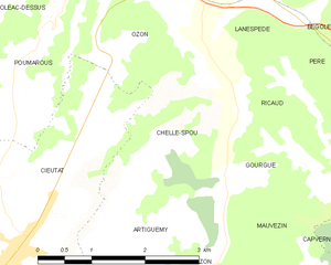
Chelle-Spou
- commune in Hautes-Pyrénées, France
- Country:
- Postal Code: 65130
- Coordinates: 43° 8' 11" N, 0° 14' 32" E
- GPS tracks (wikiloc): [Link]
- Area: 4.58 sq km
- Population: 118


Artiguemy
- commune in Hautes-Pyrénées, France
- Country:
- Postal Code: 65130
- Coordinates: 43° 7' 37" N, 0° 14' 47" E
- GPS tracks (wikiloc): [Link]
- Area: 2.97 sq km
- Population: 95


Ricaud
- commune in Hautes-Pyrénées, France
- Country:
- Postal Code: 65190
- Coordinates: 43° 8' 52" N, 0° 15' 50" E
- GPS tracks (wikiloc): [Link]
- Area: 3.3 sq km
- Population: 65


Mauvezin
- commune in Hautes-Pyrénées, France
- Country:
- Postal Code: 65130
- Coordinates: 43° 6' 54" N, 0° 17' 0" E
- GPS tracks (wikiloc): [Link]
- Area: 9.85 sq km
- Population: 235