Grézillé (Grézillé)

- former commune in Maine-et-Loire, France
- Country:

- Postal Code: 49320
- Coordinates: 47° 19' 33" N, 0° 20' 49" E


- GPS tracks (wikiloc): [Link]
- Area: 17.62 sq km
- Population: 637
- Web site: http://grezille.com/
- Wikipedia en: wiki(en)
- Wikipedia: wiki(fr)
- Wikidata storage: Wikidata: Q1163962
- Wikipedia Commons Category: [Link]
- Freebase ID: [/m/03w9jjr]
- GeoNames ID: Alt: [3014673]
- BnF ID: [15261755w]
- VIAF ID: Alt: [234846763]
- INSEE municipality code: 49154
Shares border with regions:

Louerre
- former commune in Maine-et-Loire, France
- Country:
- Postal Code: 49700
- Coordinates: 47° 17' 47" N, 0° 19' 27" E
- GPS tracks (wikiloc): [Link]
- Area: 14.44 sq km
- Population: 484
- Web site: [Link]

Saint-Georges-des-Sept-Voies
- former commune in Maine-et-Loire, France
- Country:
- Postal Code: 49350
- Coordinates: 47° 21' 0" N, 0° 17' 0" E
- GPS tracks (wikiloc): [Link]
- Area: 15.22 sq km
- Population: 709

Saulgé-l'Hôpital
- former commune in Maine-et-Loire, France
- Country:
- Postal Code: 49320
- Coordinates: 47° 17' 45" N, 0° 22' 57" E
- GPS tracks (wikiloc): [Link]
- Area: 6.6 sq km
- Population: 608
- Web site: [Link]
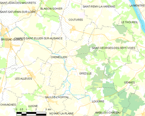
Chemellier
- former commune in Maine-et-Loire, France
- Country:
- Postal Code: 49320
- Coordinates: 47° 20' 27" N, 0° 21' 30" E
- GPS tracks (wikiloc): [Link]
- Area: 10.99 sq km
- Population: 821