Grand-Charmont (Grand-Charmont)

- commune in Doubs, France
 Hiking in Grand-Charmont
Grand-Charmont is a charming commune located in the Bourgogne-Franche-Comté region of eastern France. While it may not be as widely known as some national parks or larger hiking destinations, the surrounding area offers a variety of outdoor activities, including hiking.
Hiking Opportunities in Grand-Charmont:
-
Nearby Forests and Natural Reserves: The region is bordered by beautiful forests, such as the Forest of Chaux and the Regional Natural Park of the Haut-Jura. These areas provide various trails that range from easy walks to more challenging hikes, ideal for all skill levels.
-
Panoramic Views: Some trails lead to elevated points that offer spectacular views of the Jura Mountains and the Doubs Valley, making for excellent photography opportunities and a chance to connect with nature.
-
Local Trails: Within and around Grand-Charmont, you can find marked paths and local trails. These typically go through scenic countryside, vineyards, and small villages, allowing hikers to experience regional culture and landscapes.
-
Flora and Fauna: The hiking experience in this region is enriched by diverse flora and fauna. Keep an eye out for various bird species, deer, and other wildlife, especially in less disturbed areas.
-
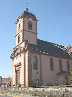
Historic Sites: There may also be historical sites along the trails, including old churches, castles, and ruins, which provide insight into the area’s history and culture.
Tips for Hiking in Grand-Charmont:
- Weather: Always check the weather forecast before heading out, as conditions can change quickly in this mountainous region.
- Gear: Wear appropriate hiking shoes and carry water, snacks, a map or GPS, and possibly a first-aid kit.
- Trail Etiquette: Respect the natural environment by sticking to trails, leaving no trace, and respecting wildlife.
- Local Advice: Consider stopping by local information centers for trail maps and recommendations tailored to your hiking preferences.
Whether you're a seasoned hiker or just looking to enjoy a leisurely walk in nature, Grand-Charmont and its surrounding areas offer a peaceful and beautiful setting for outdoor exploration.
- Country:

- Postal Code: 25200
- Coordinates: 47° 31' 38" N, 6° 49' 25" E


- GPS tracks (wikiloc): [Link]
- Area: 4.56 sq km
- Population: 5584
- Web site: http://www.grand-charmont.com
- Wikipedia en: wiki(en)
- Wikipedia: wiki(fr)
- Wikidata storage: Wikidata: Q904517
- Wikipedia Commons Category: [Link]
- Freebase ID: [/m/03mh9tn]
- Freebase ID: [/m/03mh9tn]
- GeoNames ID: Alt: [6429815]
- GeoNames ID: Alt: [6429815]
- SIREN number: [212502843]
- SIREN number: [212502843]
- BnF ID: [15252510d]
- BnF ID: [15252510d]
- INSEE municipality code: 25284
- INSEE municipality code: 25284
Shares border with regions:
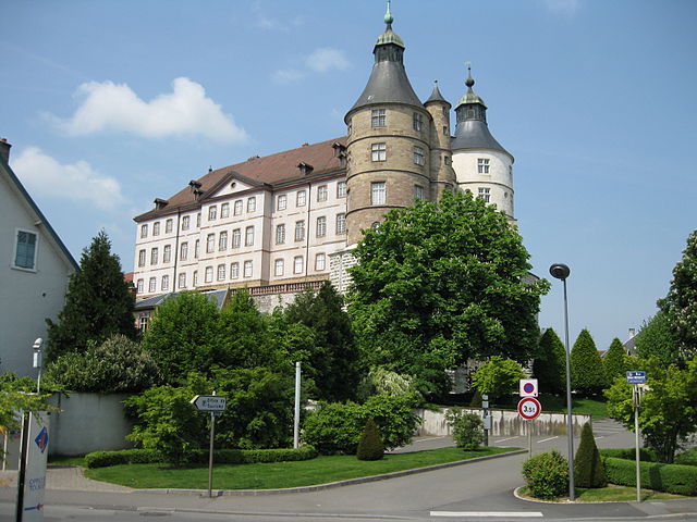

Montbéliard
- commune in Doubs, France
Hiking in Montbéliard
Montbéliard, a picturesque town located in the Bourgogne-Franche-Comté region of eastern France, offers various hiking opportunities that allow you to explore the beautiful landscapes and rich history of the area....
- Country:
- Postal Code: 25200
- Coordinates: 47° 30' 35" N, 6° 47' 54" E
- GPS tracks (wikiloc): [Link]
- AboveSeaLevel: 337 м m
- Area: 15.01 sq km
- Population: 25336
- Web site: [Link]


Sochaux
- commune in Doubs, France
Hiking in Sochaux
Sochaux is a small town in the Bourgogne-Franche-Comté region of France, primarily known for its industrial history, particularly with the Peugeot automobile company. While Sochaux itself may not be a well-known hiking destination, there are several outdoor opportunities and trails in the surrounding areas that you might explore....
- Country:
- Postal Code: 25600
- Coordinates: 47° 30' 52" N, 6° 49' 53" E
- GPS tracks (wikiloc): [Link]
- Area: 2.17 sq km
- Population: 3978
- Web site: [Link]

Châtenois-les-Forges
- commune in Territoire de Belfort, France
Hiking in Châtenois-les-Forges
Châtenois-les-Forges is a charming village located in the Vosges department of northeastern France. It's surrounded by beautiful natural landscapes, making it a great spot for hiking enthusiasts. Here are some key points about hiking in this area:...
- Country:
- Postal Code: 90700
- Coordinates: 47° 33' 33" N, 6° 50' 54" E
- GPS tracks (wikiloc): [Link]
- Area: 8.67 sq km
- Population: 2757


Nommay
- commune in Doubs, France
Hiking in Nommay
Nommay is a charming commune located in the Doubs department of France, close to the Swiss border. While it may not be as well-known as some larger hiking destinations, it offers access to beautiful landscapes and trails in the surrounding regions, particularly given its proximity to the Jura Mountains and the Vosges....
- Country:
- Postal Code: 25600
- Coordinates: 47° 32' 17" N, 6° 50' 50" E
- GPS tracks (wikiloc): [Link]
- Area: 3.19 sq km
- Population: 1672


Vieux-Charmont
- commune in Doubs, France
Hiking in Vieux-Charmont
Vieux-Charmont, located in the Bourgogne-Franche-Comté region of France, offers a variety of picturesque trails and beautiful landscapes, ideal for hiking enthusiasts. While the area itself may not be as well-known as larger national parks, it provides a charming rural escape with opportunities to explore nature....
- Country:
- Postal Code: 25600
- Coordinates: 47° 31' 29" N, 6° 50' 20" E
- GPS tracks (wikiloc): [Link]
- Area: 2.51 sq km
- Population: 2706
- Web site: [Link]