Grandola ed Uniti (Grandola ed Uniti)
- Italian comune
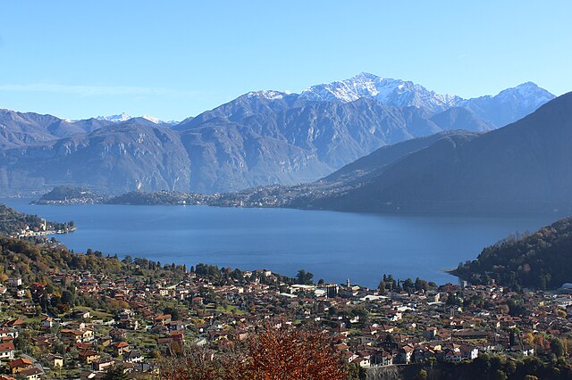
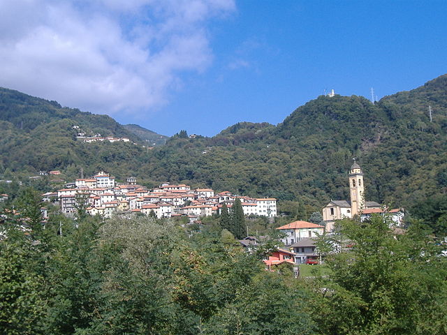
Grandola ed Uniti, located in the Italian region of Lombardy, is surrounded by stunning natural landscapes, making it an excellent destination for hiking enthusiasts. This area has a mix of terrain, including mountainous regions, forests, and lakes, providing a variety of hiking experiences suitable for different skill levels.
Hiking Trails
-
Lake Como Trails: Grandola ed Uniti is situated near the western shore of Lake Como, where numerous trails offer beautiful views of the lake and surrounding mountains. Trails can vary from leisurely walks along the shoreline to more challenging hikes up into the hills.
-
Sentiero del Viandante: This is a historical path that runs along the eastern side of Lake Como, and parts of it can be accessed from Grandola ed Uniti. It offers beautiful views of the lake and the surrounding village landscapes.
-
Local Forest Trails: The area features various forested paths that provide a serene hiking experience amidst nature. Look for well-marked trails that can lead through the beautiful chestnut trees that are common in the region.
Things to Consider
- Equipment: Depending on the trail's difficulty, proper hiking gear is essential. Good footwear, weather-appropriate clothing, and a hiking backpack with water and snacks are recommended.
- Weather: Check the weather forecast before heading out, as conditions can change rapidly in the mountains.
- Map and Navigation: Carry a map of the hiking routes or use a hiking app to ensure you stay on track. Some paths may not be well marked, so it's good to have a plan.
- Local Regulations: Make sure to follow local guidelines and regulations when hiking in natural reserves and protected areas.
Wildlife and Scenery
Hiking in this area can provide sightings of various wildlife, including birds and smaller mammals. Additionally, the beautiful vistas from higher trails offer photographers and nature lovers ample opportunities to capture the stunning landscape.
Conclusion
Hiking in Grandola ed Uniti combines natural beauty, a tranquil environment, and the rich culture of the Lombardy region. Whether you're a beginner or an experienced hiker, you'll find trails that cater to your preferences and allow you to enjoy the breathtaking scenery of this Italian gem.
- Country:

- Postal Code: 22010
- Local Dialing Code: 0344
- Licence Plate Code: CO
- Coordinates: 46° 2' 0" N, 9° 13' 0" E


- GPS tracks (wikiloc): [Link]
- AboveSeaLevel: 443 м m
- Area: 16.9 sq km
- Population: 1298
- Web site: http://www.comune.grandolaeduniti.co.it
- Wikipedia en: wiki(en)
- Wikipedia: wiki(it)
- Wikidata storage: Wikidata: Q47600
- Wikipedia Commons Category: [Link]
- Freebase ID: [/m/0gj0dv]
- GeoNames ID: Alt: [6542538]
- OSM relation ID: [46697]
- UN/LOCODE: [ITGEU]
- ISTAT ID: 013111
- Italian cadastre code: E141
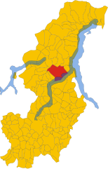
Shares border with regions:


Tremezzina
- human settlement in Italy
Tremezzina is a picturesque area located on the western shore of Lake Como in Italy. It consists of several charming towns, including Tremezzo, Lenno, and Mezzegra, all surrounded by stunning landscapes, lush greenery, and breathtaking views of the lake and the surrounding mountains. Here are some highlights about hiking in Tremezzina:...
- Country:

- Postal Code: 22016
- Local Dialing Code: 0344
- Licence Plate Code: CO
- Coordinates: 45° 58' 51" N, 9° 12' 10" E


- GPS tracks (wikiloc): [Link]
- AboveSeaLevel: 200 м m
- Area: 29.41 sq km
- Population: 5118
- Web site: [Link]


Bene Lario
- Italian comune
Bene Lario is a charming village located on the western shore of Lake Como in Italy. It offers a range of hiking opportunities that allow you to experience stunning natural beauty, historical sites, and the unique culture of the region. Here are some highlights to consider when hiking in and around Bene Lario:...
- Country:

- Postal Code: 22010
- Local Dialing Code: 0344
- Licence Plate Code: CO
- Coordinates: 46° 2' 0" N, 9° 11' 0" E


- GPS tracks (wikiloc): [Link]
- AboveSeaLevel: 370 м m
- Area: 5.59 sq km
- Population: 335
- Web site: [Link]
Carlazzo
- Italian comune
Carlazzo, located in the province of Como in Italy, is a picturesque destination for hiking enthusiasts. Nestled near the northern banks of Lake Lugano, Carlazzo offers beautiful scenery, diverse trails, and the charm of the surrounding Italian landscape....
- Country:

- Postal Code: 22010
- Local Dialing Code: 0344
- Licence Plate Code: CO
- Coordinates: 46° 3' 0" N, 9° 9' 0" E


- GPS tracks (wikiloc): [Link]
- AboveSeaLevel: 481 м m
- Area: 12.73 sq km
- Population: 3162
- Web site: [Link]


Garzeno
- Italian comune
Garzeno, located in the beautiful Valtellina region of Italy, is a lesser-known yet charming destination for hiking enthusiasts. Nestled in the Lombardy region, it offers stunning landscapes, rich flora and fauna, and a range of trails suitable for various skill levels....
- Country:

- Postal Code: 22010
- Local Dialing Code: 0344
- Licence Plate Code: CO
- Coordinates: 46° 8' 0" N, 9° 15' 0" E


- GPS tracks (wikiloc): [Link]
- AboveSeaLevel: 662 м m
- Area: 28.76 sq km
- Population: 754
- Web site: [Link]


Plesio
- Italian comune
Plesio is a charming village located in the Lombardy region of Italy, near Lake Como. It is a part of the Valtellina Valley and offers stunning views of the surrounding mountains and the lake itself. Hiking in this area can be an incredible experience, as it is blessed with natural beauty and a variety of trails suited for different skill levels....
- Country:

- Postal Code: 22010
- Local Dialing Code: 0344
- Licence Plate Code: CO
- Coordinates: 46° 2' 58" N, 9° 13' 32" E


- GPS tracks (wikiloc): [Link]
- AboveSeaLevel: 595 м m
- Area: 16.9 sq km
- Population: 840
- Web site: [Link]


Menaggio
- Italian comune
Menaggio, located on the western shore of Lake Como in Italy, is a fantastic destination for hiking enthusiasts. The area offers stunning views, diverse trails, and a beautiful natural landscape that attracts visitors year-round. Here are some things to know about hiking in Menaggio:...
- Country:

- Postal Code: 22017
- Local Dialing Code: 0344
- Licence Plate Code: CO
- Coordinates: 46° 1' 0" N, 9° 14' 0" E


- GPS tracks (wikiloc): [Link]
- AboveSeaLevel: 202 м m
- Area: 11.77 sq km
- Population: 3107
- Web site: [Link]


Cusino
- Italian comune
Hiking in Cusino, a region in northern Italy, offers a delightful experience for outdoor enthusiasts. Set in the Italian Alps, Cusino is known for its stunning landscapes, diverse flora and fauna, and a variety of trails suitable for all experience levels. Here’s what you can expect:...
- Country:

- Postal Code: 22010
- Local Dialing Code: 0344
- Licence Plate Code: CO
- Coordinates: 46° 4' 0" N, 9° 9' 0" E


- GPS tracks (wikiloc): [Link]
- AboveSeaLevel: 800 м m
- Area: 9.65 sq km
- Population: 216
- Web site: [Link]

