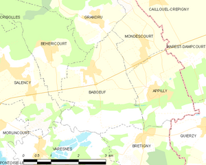
Grandrû (Grandrû)
- commune in Oise, France
- Country:

- Postal Code: 60400
- Coordinates: 49° 36' 23" N, 3° 5' 13" E


- GPS tracks (wikiloc): [Link]
- Area: 7.35 sq km
- Population: 337
- Wikipedia en: wiki(en)
- Wikipedia: wiki(fr)
- Wikidata storage: Wikidata: Q1337937
- Wikipedia Commons Category: [Link]
- Freebase ID: [/m/03qg6lt]
- GeoNames ID: Alt: [6438732]
- SIREN number: [216002840]
- INSEE municipality code: 60287
Shares border with regions:
Crisolles
- commune in Oise, France
- Country:

- Postal Code: 60400
- Coordinates: 49° 37' 17" N, 3° 0' 58" E


- GPS tracks (wikiloc): [Link]
- Area: 10.54 sq km
- Population: 983


Babœuf
- commune in Oise, France
- Country:

- Postal Code: 60400
- Coordinates: 49° 35' 20" N, 3° 5' 4" E


- GPS tracks (wikiloc): [Link]
- Area: 7.18 sq km
- Population: 529
Maucourt
- commune in Oise, France
- Country:

- Postal Code: 60640
- Coordinates: 49° 38' 11" N, 3° 4' 27" E


- GPS tracks (wikiloc): [Link]
- AboveSeaLevel: 80 м m
- Area: 3.12 sq km
- Population: 254
Quesmy
- commune in Oise, France
- Country:

- Postal Code: 60640
- Coordinates: 49° 38' 3" N, 3° 3' 33" E


- GPS tracks (wikiloc): [Link]
- Area: 4.83 sq km
- Population: 186


Béhéricourt
- commune in Oise, France
- Country:

- Postal Code: 60400
- Coordinates: 49° 35' 46" N, 3° 3' 55" E


- GPS tracks (wikiloc): [Link]
- Area: 5.3 sq km
- Population: 211
Mondescourt
- commune in Oise, France
- Country:

- Postal Code: 60400
- Coordinates: 49° 35' 55" N, 3° 6' 43" E


- GPS tracks (wikiloc): [Link]
- Area: 3.19 sq km
- Population: 254

Caillouël-Crépigny
- commune in Aisne, France
- Country:

- Postal Code: 02300
- Coordinates: 49° 37' 18" N, 3° 7' 40" E


- GPS tracks (wikiloc): [Link]
- Area: 6.63 sq km
- Population: 435
