Gravina di Catania (Gravina di Catania)
.svg)
- Italian comune
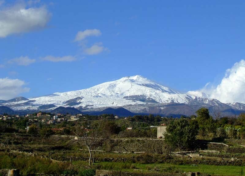
 Hiking in Gravina di Catania
Gravina di Catania, located in Sicily, Italy, offers a beautiful backdrop for hiking enthusiasts with its diverse landscapes and proximity to Mount Etna, Europe's highest and most active volcano. Here's what you can expect from hiking in this area:
Trails and Terrain
-
Mount Etna: The most popular hiking destination near Gravina di Catania. There are several marked trails that range from easy walks to more challenging treks. The Monti Silvestri trail is known for its unique volcanic landscapes and offers stunning views of the surrounding area.
-
Parco dell'Etna: The regional park surrounding Mount Etna features numerous trails that allow you to explore the biodiversity of the area, ancient lava flows, and craters. The landscape varies from dense forests to barren volcanic terrain.
-
The Alcantara Gorges: A short drive from Gravina di Catania, this area offers hiking opportunities along the Alcantara River, where you can enjoy spectacular lava formations, waterfalls, and lush vegetation.
Hiking Difficulty
- There are trails for all levels, from easy walks suitable for families to more strenuous hikes for experienced trekkers.
- Hiking to the summit of Mount Etna requires a good level of fitness and sometimes the assistance of a guide, especially if you plan to explore the craters.
Best Time to Hike
- Spring and Autumn: These seasons offer ideal hiking conditions with milder temperatures and vibrant flora.
- Summer: While possible to hike, it can get quite hot, so early morning or late afternoon hikes are advisable.
- Winter: Snow can cover higher altitudes, providing opportunities for snow-shoeing or winter hiking, but caution is necessary.
Precautions and Tips
- Always check weather conditions before heading out, especially around Mount Etna, as conditions can change rapidly.
- Bring sufficient water, snacks, and a first aid kit.
- Wear sturdy and comfortable hiking boots, as some trails can be rocky.
- It's advisable to carry a map or use a GPS device, as trails may not always be well-marked.
- Consider following a guided hike, especially if you're unfamiliar with the terrain.
Conclusion
Hiking in Gravina di Catania and its surrounding areas provides a fantastic experience with breathtaking views and the opportunity to explore unique volcanic landscapes. Always prioritize safety and enjoy the natural beauty of Sicily!
- Country:

- Postal Code: 95030
- Local Dialing Code: 095
- Licence Plate Code: CT
- Coordinates: 37° 34' 0" N, 15° 4' 0" E


- GPS tracks (wikiloc): [Link]
- AboveSeaLevel: 355 м m
- Area: 5.15 sq km
- Population: 25399
- Web site: http://www.comune.gravina-di-catania.ct.it
- Wikipedia en: wiki(en)
- Wikipedia: wiki(it)
- Wikidata storage: Wikidata: Q478338
- Wikipedia Commons Category: [Link]
- Freebase ID: [/m/0gqh53]
- GeoNames ID: Alt: [6542346]
- OSM relation ID: [39281]
- ISTAT ID: 087019
- Italian cadastre code: E156
Shares border with regions:

Catania
- Italian city on the east coast of Sicily
Hiking in Catania
Catania, located on the eastern coast of Sicily, offers a variety of hiking opportunities that showcase the region's stunning natural beauty, historical sites, and diverse ecosystems. Here are some highlights for those interested in hiking in and around Catania:...
- Country:
- Postal Code: 95121–95131
- Local Dialing Code: 095
- Licence Plate Code: CT
- Coordinates: 37° 30' 10" N, 15° 5' 14" E
- GPS tracks (wikiloc): [Link]
- AboveSeaLevel: 7 м m
- Area: 180.88 sq km
- Population: 313396
- Web site: [Link]

Mascalucia
- Italian comune
Hiking in Mascalucia
Mascalucia, located on the slopes of Mount Etna in Sicily, Italy, is an excellent destination for hikers seeking both beautiful landscapes and unique volcanic features. Here are some key points to consider about hiking in the area:...
- Country:
- Postal Code: 95030
- Local Dialing Code: 095
- Licence Plate Code: CT
- Coordinates: 37° 34' 0" N, 15° 3' 0" E
- GPS tracks (wikiloc): [Link]
- AboveSeaLevel: 420 м m
- Area: 16.28 sq km
- Population: 32167
- Web site: [Link]
Sant'Agata li Battiati
- Italian comune
Hiking in Sant'Agata li Battiati
Sant'Agata li Battiati, located near Catania on the eastern coast of Sicily, is not only a charming town but also a great starting point for hiking enthusiasts. The surrounding landscape offers a mix of natural beauty, including hills, lava flows from Mount Etna, and stunning views of the Mediterranean Sea and the Etna volcano....
- Country:
- Postal Code: 95030
- Local Dialing Code: 095
- Licence Plate Code: CT
- Coordinates: 37° 33' 30" N, 15° 4' 50" E
- GPS tracks (wikiloc): [Link]
- AboveSeaLevel: 263 м m
- Area: 3.12 sq km
- Population: 9518
- Web site: [Link]
Tremestieri Etneo
- Italian comune
Hiking in Tremestieri Etneo
Tremestieri Etneo is a charming town located at the foothills of Mount Etna in Sicily, Italy. This area is not only rich in local culture and picturesque landscapes but also offers a variety of hiking opportunities for enthusiasts of all levels. Here are some key highlights about hiking in Tremestieri Etneo:...
- Country:
- Postal Code: 95030
- Local Dialing Code: 095
- Licence Plate Code: CT
- Coordinates: 37° 35' 0" N, 15° 5' 0" E
- GPS tracks (wikiloc): [Link]
- AboveSeaLevel: 400 м m
- Area: 6.52 sq km
- Population: 20356
- Web site: [Link]