Gualtieri (Gualtieri)
.svg)
- Italian comune
 Hiking in Gualtieri
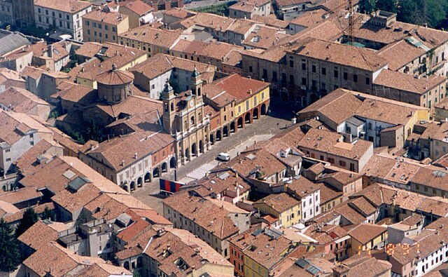
Gualtieri is a charming town in the Emilia-Romagna region of Italy, known for its picturesque landscapes and historical architecture. While not as widely recognized as some other hiking destinations, it offers a variety of outdoor opportunities for nature lovers and hikers.
Hiking Opportunities in Gualtieri:
-
Surrounding Trails: The area around Gualtieri features several trails that meander through the countryside, including farmland, vineyards, and along the banks of the Po River. These trails often provide panoramic views of the surrounding hills and the river valley.
-
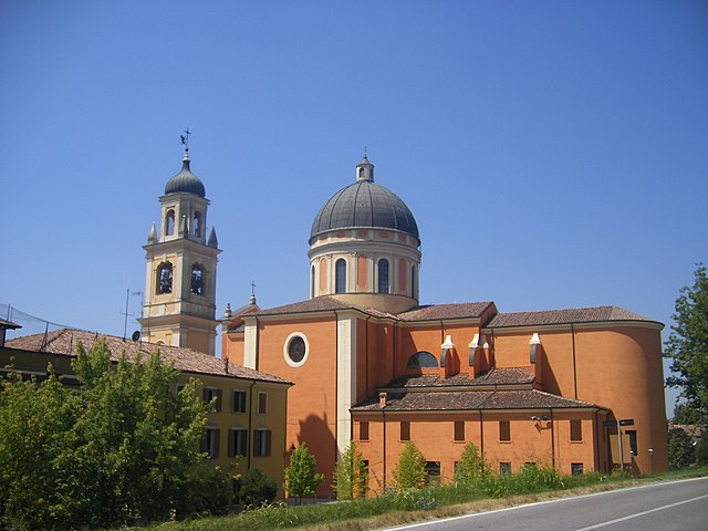
Cultural and Historical Sites: While hiking, you can explore the history of the area. The town itself has a lovely historic center with beautiful buildings, including the Church of San Bartolomeo and Palazzo Bentivoglio. Incorporating cultural stops along your hike can enrich your experience.
-
Natural Reserves: Depending on the season, you might also consider exploring nearby natural reserves. The regional parks in Emilia-Romagna offer varied terrain and ecosystems that are perfect for hiking and observing local wildlife.
-
Duration and Difficulty: The trails in the area range from easy walks suitable for families to more challenging hikes for experienced trekkers. It’s essential to check trail maps and conditions before heading out, as well as to consider how long you plan to hike.
Tips for Hiking in Gualtieri:
-
Plan Your Route: Familiarize yourself with local maps and hiking guides. The local tourist information office can provide valuable resources.
-
Check the Weather: Weather conditions can change rapidly, so dress in layers and be prepared for rain or temperature changes.
-
Stay Hydrated: Carry enough water and snacks, especially on longer hikes, as facilities may be limited on the trails.
-
Respect Local Guidelines: Stick to marked trails and practice Leave No Trace principles to help preserve the natural beauty of the area.
-
Local Flora and Fauna: Take time to appreciate the unique plants and animals you may encounter. Early morning or late afternoon hikes often provide the best chances for wildlife viewing.
Conclusion:
Hiking in Gualtieri can be a delightful way to experience the beauty of the Emilia-Romagna countryside. Whether you're interested in leisurely walks or more strenuous hikes, the region offers a blend of natural beauty and cultural heritage that makes for an enriching outdoor adventure. Always remember to respect the environment and enjoy your time exploring!
- Country:

- Postal Code: 42044
- Local Dialing Code: 0522
- Licence Plate Code: RE
- Coordinates: 44° 54' 0" N, 10° 38' 0" E


- GPS tracks (wikiloc): [Link]
- AboveSeaLevel: 22 м m
- Area: 35.65 sq km
- Population: 6471
- Web site: http://www.comune.gualtieri.re.it
- Wikipedia en: wiki(en)
- Wikipedia: wiki(it)
- Wikidata storage: Wikidata: Q111202
- Wikipedia Commons Category: [Link]
- Freebase ID: [/m/0gkfmq]
- GeoNames ID: Alt: [6539942]
- VIAF ID: Alt: [132049369]
- OSM relation ID: [43726]
- GND ID: Alt: [4359177-2]
- MusicBrainz area ID: [7283bd14-24c8-4beb-94d3-e89362179d5c]
- UN/LOCODE: [ITGLT]
- NKCR AUT ID: [ge901579]
- ISTAT ID: 035023
- Italian cadastre code: E232
Shares border with regions:

Boretto
- Italian comune
Hiking in Boretto
Boretto, located in the Emilia-Romagna region of Italy, is more known for its scenic riverside views along the Po River and its charming historical architecture rather than extensive hiking trails. However, there are still great opportunities for walking and exploring the natural surroundings....
- Country:
- Postal Code: 42022
- Local Dialing Code: 0522
- Licence Plate Code: RE
- Coordinates: 44° 54' 0" N, 10° 33' 0" E
- GPS tracks (wikiloc): [Link]
- AboveSeaLevel: 23 м m
- Area: 18.11 sq km
- Population: 5345
- Web site: [Link]

Cadelbosco di Sopra
- Italian comune
Hiking in Cadelbosco di Sopra
Cadelbosco di Sopra, located in the northern part of Italy near the city of Reggio Emilia, offers a mix of scenic landscapes and cultural experiences for hikers. The area features rolling hills, forests, and agricultural fields, providing diverse trails suitable for various skill levels....
- Country:
- Postal Code: 42023
- Local Dialing Code: 0522
- Licence Plate Code: RE
- Coordinates: 44° 46' 0" N, 10° 36' 0" E
- GPS tracks (wikiloc): [Link]
- AboveSeaLevel: 33 м m
- Area: 43.6 sq km
- Population: 10691
- Web site: [Link]


Castelnovo di Sotto
- Italian comune
Hiking in Castelnovo di Sotto
Castelnovo di Sotto is a charming town located in the Emilia-Romagna region of Italy. While it may not be as well-known as some major hiking destinations, it offers a unique rural setting and access to beautiful landscapes. Here are some insights into hiking in the area:...
- Country:
- Postal Code: 42024
- Local Dialing Code: 0522
- Licence Plate Code: RE
- Coordinates: 44° 49' 0" N, 10° 34' 0" E
- GPS tracks (wikiloc): [Link]
- AboveSeaLevel: 27 м m
- Area: 35.01 sq km
- Population: 8459
- Web site: [Link]

Guastalla
- Italian comune
Hiking in Guastalla
Guastalla is a charming town located in the Emilia-Romagna region of Italy, known for its historical significance and beautiful landscapes along the Po River. While Guastalla itself is not a major hiking destination, there are several opportunities for hiking and enjoying nature in and around the area....
- Country:
- Postal Code: 42016
- Local Dialing Code: 0522
- Licence Plate Code: RE
- Coordinates: 44° 55' 17" N, 10° 39' 15" E
- GPS tracks (wikiloc): [Link]
- AboveSeaLevel: 24 м m
- Area: 52.93 sq km
- Population: 15032
- Web site: [Link]


Dosolo
- Italian comune
Hiking in Dosolo
Dosolo is a small municipality located in the Lombardy region of northern Italy, specifically in the province of Mantua. While it is not widely known as a hiking destination, its surrounding area offers some opportunities for those looking to combine hiking with the exploration of the picturesque countryside and local culture....
- Country:
- Postal Code: 46030
- Local Dialing Code: 0375
- Licence Plate Code: MN
- Coordinates: 44° 57' 0" N, 10° 38' 0" E
- GPS tracks (wikiloc): [Link]
- AboveSeaLevel: 25 м m
- Area: 25.54 sq km
- Population: 3414
- Web site: [Link]


Pomponesco
- Italian comune
Hiking in Pomponesco
Pomponesco is a small commune located in the Lombardy region of Italy, near the River Po. While it may not be a widely recognized hiking destination compared to larger nearby national parks or mountainous areas, there are opportunities to explore the scenic countryside and enjoy hikes along the river, through agricultural landscapes, and in nearby natural reserves....
- Country:
- Postal Code: 46030
- Local Dialing Code: 0375
- Licence Plate Code: MN
- Coordinates: 44° 55' 47" N, 10° 35' 50" E
- GPS tracks (wikiloc): [Link]
- AboveSeaLevel: 23 м m
- Area: 12.56 sq km
- Population: 1686
- Web site: [Link]