Guignecourt (Guignecourt)

- commune in Oise, France
- Country:

- Postal Code: 60480
- Coordinates: 49° 28' 57" N, 2° 7' 45" E


- GPS tracks (wikiloc): [Link]
- Area: 4.62 sq km
- Population: 379
- Web site: http://www.guignecourt.fr
- Wikipedia en: wiki(en)
- Wikipedia: wiki(fr)
- Wikidata storage: Wikidata: Q1113608
- Wikipedia Commons Category: [Link]
- Freebase ID: [/m/03qgn6_]
- GeoNames ID: Alt: [6438735]
- SIREN number: [216002873]
- BnF ID: [15267528w]
- INSEE municipality code: 60290
Shares border with regions:


Bonlier
- commune in Oise, France
- Country:
- Postal Code: 60510
- Coordinates: 49° 28' 14" N, 2° 8' 59" E
- GPS tracks (wikiloc): [Link]
- Area: 4.47 sq km
- Population: 419


Verderel-lès-Sauqueuse
- commune in Oise, France
- Country:
- Postal Code: 60112
- Coordinates: 49° 30' 11" N, 2° 5' 50" E
- GPS tracks (wikiloc): [Link]
- AboveSeaLevel: 137 м m
- Area: 12.46 sq km
- Population: 736

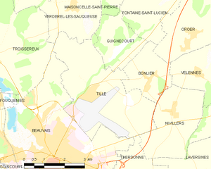
Tillé
- commune in Oise, France
- Country:
- Postal Code: 60000
- Coordinates: 49° 27' 48" N, 2° 6' 42" E
- GPS tracks (wikiloc): [Link]
- Area: 14.8 sq km
- Population: 1093


Fontaine-Saint-Lucien
- commune in Oise, France
- Country:
- Postal Code: 60480
- Coordinates: 49° 29' 56" N, 2° 8' 48" E
- GPS tracks (wikiloc): [Link]
- Area: 7.25 sq km
- Population: 158


Maisoncelle-Saint-Pierre
- commune in Oise, France
- Country:
- Postal Code: 60112
- Coordinates: 49° 30' 40" N, 2° 7' 37" E
- GPS tracks (wikiloc): [Link]
- Area: 4.16 sq km
- Population: 155